Property Record
1785 Pine St, Concord, CA 94520
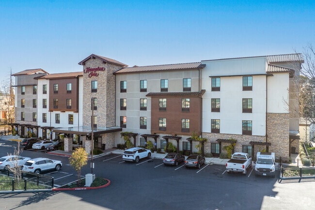

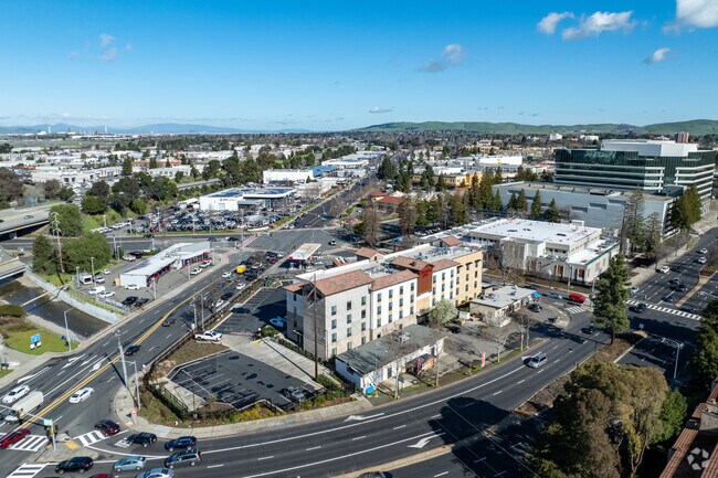
Property Detail
1785 Pine St
126-291-023-3
POR RO MONTE DEL DIABLO
Motel
CONTRA COSTA
A Areas with a 1% annual chance of flooding and a 26% chance of flooding over the life of a 30-year mortgage.
California
2025
1.24 AC
2025
Oakland Northeast/Concord
336103
East Bay/Oakland
48,100 SF
Oakland-Fremont-Berkeley, CA
NEARBY LISTINGS FOR SALE OR LEASE
-
-
View all Concord listings for sale on LoopNet.com
DEMOGRAPHICS near 1785 Pine St
1 mile
3 mile
5 mile
2025 Total Population
23,800
146,289
262,423
2030 Population
24,010
147,234
264,657
Pop Growth 2025-2030
+ 0.88%
+ 0.65%
+ 0.85%
Average Age
37
41
42
2025 Total Households
8,726
55,878
101,924
HH Growth 2025-2030
+ 1.11%
+ 0.70%
+ 0.95%
Median Household Inc
$71,650
$114,456
$127,813
Avg Household Size
2.60
2.50
2.50
2025 Avg HH Vehicles
1.00
2.00
2.00
Median Home Value
$519,970
$783,403
$847,641
Median Year Built
1975
1971
1973
Nearby Places
Map Layers
Map Styles
 Street
 Aerial
Transit
 Traffic
 Biking
Places
Listings with unknown addresses are not visible on the map
- Restaurants
- Banks
- Shops
- Fitness
- Groceries
PUBLIC TRANSPORTATION
COMMUTER RAIL
Drive
Walk
Distance
12 min
7.9 mi
AIRPORT
Metro Oakland International
Drive
Walk
Distance
Metro Oakland International
39 min
28.4 mi
San Francisco International
Drive
Walk
Distance
San Francisco International
57 min
40.3 mi
Nearby Properties
Address
Land Use
TOTAL SIZE
Lot Size
Zoning
Address
Land Use
TOTAL SIZE
Lot Size
Zoning
562,584 SF
13.43 AC
Address
Land Use
TOTAL SIZE
Lot Size
Zoning
489,813 SF
38.82 AC
Address
Land Use
TOTAL SIZE
Lot Size
Zoning
34,226 SF
30 AC
Address
Land Use
TOTAL SIZE
Lot Size
Zoning
25,089 SF
57.67 AC
HI
Address
Land Use
TOTAL SIZE
Lot Size
Zoning
254,940 SF
1.61 AC
P1
Address
Land Use
TOTAL SIZE
Lot Size
Zoning
31,614 SF
24.46 AC
Address
Land Use
TOTAL SIZE
Lot Size
Zoning
203,454 SF
2.33 AC
Address
Land Use
TOTAL SIZE
Lot Size
Zoning
5.52 AC
P1
Address
Land Use
TOTAL SIZE
Lot Size
Zoning
235,495 SF
2.51 AC
P1
Address
Land Use
TOTAL SIZE
Lot Size
Zoning
250,032 SF
7.95 AC
P1
Address
Land Use
TOTAL SIZE
Lot Size
Zoning
234,624 SF
6.63 AC
Address
Land Use
TOTAL SIZE
Lot Size
Zoning
112,000 SF
18.40 AC
Address
Land Use
TOTAL SIZE
Lot Size
Zoning
168,606 SF
2.42 AC
Address
Land Use
TOTAL SIZE
Lot Size
Zoning
152,581 SF
1.39 AC
Address
Land Use
TOTAL SIZE
Lot Size
Zoning
192,387 SF
17.42 AC
M17
Address
Land Use
TOTAL SIZE
Lot Size
Zoning
301,628 SF
1.68 AC
Address
Land Use
TOTAL SIZE
Lot Size
Zoning
130,000 SF
2.62 AC
Address
Land Use
TOTAL SIZE
Lot Size
Zoning
12,864 SF
5.62 AC
Address
Land Use
TOTAL SIZE
Lot Size
Zoning
100,627 SF
6.47 AC
Address
Land Use
TOTAL SIZE
Lot Size
Zoning
166,144 SF
19.22 AC
Address
Land Use
TOTAL SIZE
Lot Size
Zoning
59.41 AC
Address
Land Use
TOTAL SIZE
Lot Size
Zoning
45,744 SF
9.49 AC
Address
Land Use
TOTAL SIZE
Lot Size
Zoning
164,517 SF
3.65 AC
Address
Land Use
TOTAL SIZE
Lot Size
Zoning
154,213 SF
1.74 AC
Address
Land Use
TOTAL SIZE
Lot Size
Zoning
109,000 SF
1.98 AC
Address
Land Use
TOTAL SIZE
Lot Size
Zoning
225,367 SF
7.42 AC
Address
Land Use
TOTAL SIZE
Lot Size
Zoning
86,074 SF
2.17 AC
Address
Land Use
TOTAL SIZE
Lot Size
Zoning
92,550 SF
3.88 AC
Address
Land Use
TOTAL SIZE
Lot Size
Zoning
3,036 SF
11.11 AC
Address
Land Use
TOTAL SIZE
Lot Size
Zoning
155,725 SF
15.82 AC
The World's #1 Commercial Real Estate Marketplace
Connect with us
© 2026 CoStar Group
The information above has been obtained from sources believed reliable. While we do not doubt its accuracy we have not verified it and make no guarantee, warranty or representation about it. It is your responsibility to independently confirm its accuracy and completeness. Any projections, opinions, assumptions, or estimates used are for example only and do not represent the current or future performance of the property. The value of this transaction to you depends on tax and other factors which should be evaluated by your tax, financial, and legal advisors. You and your advisors should conduct a careful, independent investigation of the property to determine to your satisfaction the suitability of the property for your needs.