Property Record
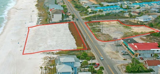
17851 Front Beach Rd, Panama City Beach, FL 32413

Property Detail
17851 Front Beach Rd
38405-000-000
WELLS GULF BEACH ESTATES -5.25- 21B1 BEG INT OF THE WEST LINE LOT 2 BLK 1 MIRAMAR BEACH AND THE SLY R/W LINE OF FRONT BEACH RD TH SW ALONG THE WEST LINE OF LOT 2 52 S 30.91 SW 68 M/L TO WATERS EDGE TH NWLY ALONG WATER 380M/L TH NORTH 163 M/L TO SLY R
Commercialacreage
BAY
PCB21
Florida
VE and V1-30 Coastal areas with a 1% or greater chance of flooding and an additional hazard associated with storm waves. These areas have a 26% chance of flooding over the life of a 30-year mortgage.
2
2024
2.28 AC
2025
Panama City
002709
Other Market Areas
4,804 SF
Panama City-Panama City Beach, FL
NEARBY LISTINGS FOR SALE OR LEASE
DEMOGRAPHICS near 17851 Front Beach Rd
1 mile
3 mile
5 mile
2025 Total Population
4,756
18,027
28,448
2030 Population
5,816
21,699
33,897
Pop Growth 2025-2030
+ 22.29%
+ 20.37%
+ 19.15%
Average Age
50
47
47
2025 Total Households
2,384
8,527
13,142
HH Growth 2025-2030
+ 22.73%
+ 20.82%
+ 19.69%
Median Household Inc
$67,418
$80,986
$83,002
Avg Household Size
2.00
2.10
2.10
2025 Avg HH Vehicles
2.00
2.00
2.00
Median Home Value
$441,287
$427,670
$426,170
Median Year Built
1998
2000
1998
Nearby Places
Map Layers
Map Styles
 Street
 Aerial
Transit
 Traffic
 Biking
Places
Listings with unknown addresses are not visible on the map
- Restaurants
- Banks
- Shops
- Fitness
- Groceries
PUBLIC TRANSPORTATION
AIRPORT
Northwest Florida Beaches International
Drive
Walk
Distance
Northwest Florida Beaches International
22 min
14.1 mi
Freight Ports
Port of Panama City
Drive
Walk
Distance
Port of Panama City
22 min
12.4 mi
Nearby Properties
Address
Land Use
TOTAL SIZE
Lot Size
Zoning
Address
Land Use
TOTAL SIZE
Lot Size
Zoning
377,394 SF
25.70 AC
PCB03
Address
Land Use
TOTAL SIZE
Lot Size
Zoning
309,733 SF
20.99 AC
PCB22
Address
Land Use
TOTAL SIZE
Lot Size
Zoning
300,798 SF
46.27 AC
PCB22
Address
Land Use
TOTAL SIZE
Lot Size
Zoning
311,259 SF
19.63 AC
PCB22
Address
Land Use
TOTAL SIZE
Lot Size
Zoning
268,899 SF
25.84 AC
PCB22
Address
Land Use
TOTAL SIZE
Lot Size
Zoning
236,400 SF
17.73 AC
PCB09
Address
Land Use
TOTAL SIZE
Lot Size
Zoning
213,260 SF
6.45 AC
PCB22
Address
Land Use
TOTAL SIZE
Lot Size
Zoning
280,944 SF
34.17 AC
PCB09
Address
Land Use
TOTAL SIZE
Lot Size
Zoning
22,200 SF
88.65 AC
PCB09
Address
Land Use
TOTAL SIZE
Lot Size
Zoning
2,640 SF
30.77 AC
PCB22
Address
Land Use
TOTAL SIZE
Lot Size
Zoning
12,526 SF
101.10 AC
PCB10
Address
Land Use
TOTAL SIZE
Lot Size
Zoning
4,925 SF
2.07 AC
PCB21
Address
Land Use
TOTAL SIZE
Lot Size
Zoning
117,981 SF
10 AC
PCB22
Address
Land Use
TOTAL SIZE
Lot Size
Zoning
56,438 SF
2.08 AC
PCB21
Address
Land Use
TOTAL SIZE
Lot Size
Zoning
140,821 SF
9.98 AC
Address
Land Use
TOTAL SIZE
Lot Size
Zoning
75,832 SF
2.94 AC
BC23
Address
Land Use
TOTAL SIZE
Lot Size
Zoning
55 AC
PCB09
Address
Land Use
TOTAL SIZE
Lot Size
Zoning
42,532 SF
2.73 AC
PCB22
Address
Land Use
TOTAL SIZE
Lot Size
Zoning
50,064 SF
2.17 AC
PCB07
Address
Land Use
TOTAL SIZE
Lot Size
Zoning
106,035 SF
2.45 AC
BC04
Address
Land Use
TOTAL SIZE
Lot Size
Zoning
53,302 SF
8.26 AC
PCB17
Address
Land Use
TOTAL SIZE
Lot Size
Zoning
53,733 SF
0.83 AC
PCB21
Address
Land Use
TOTAL SIZE
Lot Size
Zoning
23.96 AC
PCB24
Address
Land Use
TOTAL SIZE
Lot Size
Zoning
50,285 SF
8.48 AC
PCB22
Address
Land Use
TOTAL SIZE
Lot Size
Zoning
51.04 AC
PCB10
Address
Land Use
TOTAL SIZE
Lot Size
Zoning
39,552 SF
1.27 AC
PCB21
Address
Land Use
TOTAL SIZE
Lot Size
Zoning
52,338 SF
1.52 AC
PCB21
Address
Land Use
TOTAL SIZE
Lot Size
Zoning
65,082 SF
2.28 AC
PCB21
Address
Land Use
TOTAL SIZE
Lot Size
Zoning
125,376 SF
10.19 AC
PCB22
The World's #1 Commercial Real Estate Marketplace
Connect with us
© 2026 CoStar Group
The information above has been obtained from sources believed reliable. While we do not doubt its accuracy we have not verified it and make no guarantee, warranty or representation about it. It is your responsibility to independently confirm its accuracy and completeness. Any projections, opinions, assumptions, or estimates used are for example only and do not represent the current or future performance of the property. The value of this transaction to you depends on tax and other factors which should be evaluated by your tax, financial, and legal advisors. You and your advisors should conduct a careful, independent investigation of the property to determine to your satisfaction the suitability of the property for your needs.