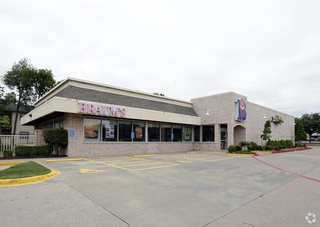
Property Record
17879 Preston Rd, Dallas, TX 75252

Property Detail
17879 Preston Rd
R-3099-00V-0040-1
BRAUMS / PRESTON ROAD ADDITION, BLK V/8730, LOT 4
Commercialnec
COLLIN
RT
Texas
B and X Area of moderate flood hazard, usually the area between the limits of the 100-year and 500-year floods.
4
2025
1.29 AC
2025
Addison
031708
Dallas/Ft Worth
4,829 SF
Dallas-Fort Worth-Arlington, TX
NEARBY LISTINGS FOR SALE OR LEASE
DEMOGRAPHICS near 17879 Preston Rd
1 mile
3 mile
5 mile
2024 Total Population
15,698
152,123
400,100
2029 Population
18,553
172,735
448,320
Pop Growth 2024-2029
+ 18.19%
+ 13.55%
+ 12.05%
Average Age
43
39
39
2024 Total Households
7,540
70,579
175,528
HH Growth 2024-2029
+ 18.82%
+ 14.25%
+ 12.45%
Median Household Inc
$85,569
$72,543
$77,030
Avg Household Size
2.00
2.00
2.20
2024 Avg HH Vehicles
2.00
2.00
2.00
Median Home Value
$565,580
$453,942
$394,470
Median Year Built
1986
1987
1986
Nearby Places
Map Layers
Map Styles
 Street
 Aerial
Transit
 Traffic
 Biking
Places
Listings with unknown addresses are not visible on the map
- Restaurants
- Banks
- Shops
- Fitness
- Groceries
PUBLIC TRANSPORTATION
AIRPORT
Dallas Love Field
Drive
Walk
Distance
Dallas Love Field
23 min
14.6 mi
Dallas-Fort Worth International
Drive
Walk
Distance
Dallas-Fort Worth International
29 min
22.9 mi
Nearby Properties
Address
Land Use
TOTAL SIZE
Lot Size
Zoning
Address
Land Use
TOTAL SIZE
Lot Size
Zoning
1,614,550 SF
77.76 AC
SFR
Address
Land Use
TOTAL SIZE
Lot Size
Zoning
492,661 SF
4.89 AC
Address
Land Use
TOTAL SIZE
Lot Size
Zoning
343,539 SF
34.74 AC
S-164
Address
Land Use
TOTAL SIZE
Lot Size
Zoning
659,402 SF
24.39 AC
O-M
Address
Land Use
TOTAL SIZE
Lot Size
Zoning
686,032 SF
9 AC
R2000
Address
Land Use
TOTAL SIZE
Lot Size
Zoning
1,034,981 SF
8.37 AC
Z422
Address
Land Use
TOTAL SIZE
Lot Size
Zoning
369,694 SF
Address
Land Use
TOTAL SIZE
Lot Size
Zoning
533,962 SF
29.78 AC
MF-M
Address
Land Use
TOTAL SIZE
Lot Size
Zoning
445,071 SF
107.94 AC
2493-A TO-
Address
Land Use
TOTAL SIZE
Lot Size
Zoning
481,366 SF
6.31 AC
LC
Address
Land Use
TOTAL SIZE
Lot Size
Zoning
619,645 SF
5.16 AC
Z422
Address
Land Use
TOTAL SIZE
Lot Size
Zoning
430,618 SF
11.33 AC
MF-H
Address
Land Use
TOTAL SIZE
Lot Size
Zoning
429,576 SF
22.03 AC
Z236
Address
Land Use
TOTAL SIZE
Lot Size
Zoning
520,713 SF
8.03 AC
Address
Land Use
TOTAL SIZE
Lot Size
Zoning
393,416 SF
Address
Land Use
TOTAL SIZE
Lot Size
Zoning
482,025 SF
11.73 AC
LC
Address
Land Use
TOTAL SIZE
Lot Size
Zoning
451,672 SF
23.81 AC
LI-1
Address
Land Use
TOTAL SIZE
Lot Size
Zoning
696,563 SF
19.77 AC
Z239
Address
Land Use
TOTAL SIZE
Lot Size
Zoning
435,696 SF
3 AC
PD
Address
Land Use
TOTAL SIZE
Lot Size
Zoning
386,448 SF
Address
Land Use
TOTAL SIZE
Lot Size
Zoning
561,142 SF
4.64 AC
MU-2
Address
Land Use
TOTAL SIZE
Lot Size
Zoning
595,188 SF
6.16 AC
Z239
Address
Land Use
TOTAL SIZE
Lot Size
Zoning
384,424 SF
377.56 AC
Z119
Address
Land Use
TOTAL SIZE
Lot Size
Zoning
739,099 SF
3.34 AC
Z236
Address
Land Use
TOTAL SIZE
Lot Size
Zoning
517,362 SF
23.61 AC
MF-2
Address
Land Use
TOTAL SIZE
Lot Size
Zoning
396,669 SF
18.50 AC
Address
Land Use
TOTAL SIZE
Lot Size
Zoning
1,130,618 SF
6.01 AC
Z32
Address
Land Use
TOTAL SIZE
Lot Size
Zoning
245,542 SF
26.31 AC
RT/O-M
Address
Land Use
TOTAL SIZE
Lot Size
Zoning
511,780 SF
5.88 AC
Z31
The World's #1 Commercial Real Estate Marketplace
Connect with us
© 2026 CoStar Group
The information above has been obtained from sources believed reliable. While we do not doubt its accuracy we have not verified it and make no guarantee, warranty or representation about it. It is your responsibility to independently confirm its accuracy and completeness. Any projections, opinions, assumptions, or estimates used are for example only and do not represent the current or future performance of the property. The value of this transaction to you depends on tax and other factors which should be evaluated by your tax, financial, and legal advisors. You and your advisors should conduct a careful, independent investigation of the property to determine to your satisfaction the suitability of the property for your needs.