Property Record
179 Flanders Rd, Niantic, CT 06357
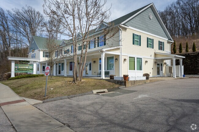

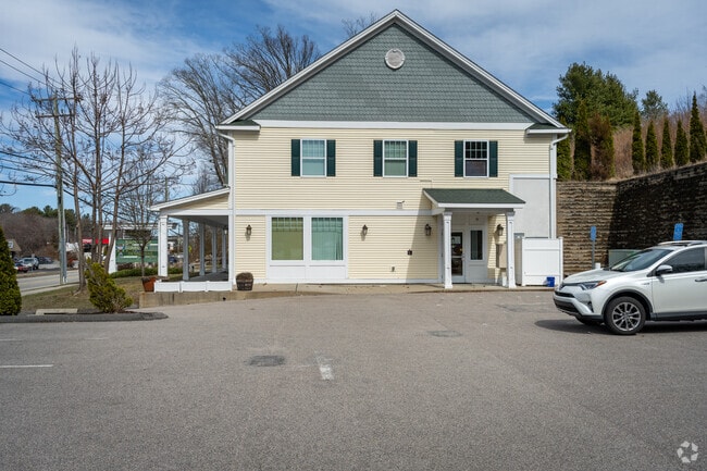
Property Detail
179 Flanders Rd
Commercialbuilding
Southeastern Ct
CA
Connecticut
B and X Area of moderate flood hazard, usually the area between the limits of the 100-year and 500-year floods.
1.70 AC
2025
SW New London/East Lyme
2025
Hartford
870701
Norwich-New London-Willimantic, CT
9,054 SF
ELYM-002603-000046
NEARBY LISTINGS FOR SALE OR LEASE
DEMOGRAPHICS near 179 Flanders Rd
1 mile
3 mile
5 mile
2025 Total Population
2,566
20,670
41,566
2030 Population
2,624
21,161
42,525
Pop Growth 2025-2030
+ 2.26%
+ 2.38%
+ 2.31%
Average Age
46
46
46
2025 Total Households
1,106
8,723
17,445
HH Growth 2025-2030
+ 2.08%
+ 2.50%
+ 2.40%
Median Household Inc
$102,351
$104,237
$103,239
Avg Household Size
2.30
2.20
2.30
2025 Avg HH Vehicles
2.00
2.00
2.00
Median Home Value
$391,586
$393,339
$392,658
Median Year Built
1973
1972
1970
Nearby Places
Map Layers
Map Styles
 Street
 Aerial
Layers
 Traffic
 Biking
Places
Listings with unknown addresses are not visible on the map
- Restaurants
- Banks
- Shops
- Fitness
- Groceries
PUBLIC TRANSPORTATION
COMMUTER RAIL
New London (Shore Line East - Shore Line East)
Drive
Walk
Distance
New London (Shore Line East - Shore Line East)
13 min
7.8 mi
SALE & LEASE HISTORY
LISTING DATE
SALE/LEASE

Mar 17, 2021
For Lease
Jul 09, 2019
For Lease
Feb 23, 2022
For Lease
Dec 16, 2022
For Lease
Aug 21, 2023
For Lease
Aug 07, 2024
For Lease
Nearby Properties
Address
Land Use
TOTAL SIZE
Lot Size
Zoning
Address
Land Use
TOTAL SIZE
Lot Size
Zoning
66.17 AC
LI
Address
Land Use
TOTAL SIZE
Lot Size
Zoning
1,256 SF
64.84 AC
R40
Address
Land Use
TOTAL SIZE
Lot Size
Zoning
617.95 AC
Address
Land Use
TOTAL SIZE
Lot Size
Zoning
35.08 AC
GDPP
Address
Land Use
TOTAL SIZE
Lot Size
Zoning
61.04 AC
CA
Address
Land Use
TOTAL SIZE
Lot Size
Zoning
47,148 SF
101.29 AC
IP-1
Address
Land Use
TOTAL SIZE
Lot Size
Zoning
68.87 AC
GDPP
Address
Land Use
TOTAL SIZE
Lot Size
Zoning
68,244 SF
25.67 AC
R-40
Address
Land Use
TOTAL SIZE
Lot Size
Zoning
56.50 AC
C-R
Address
Land Use
TOTAL SIZE
Lot Size
Zoning
14.76 AC
CA
Address
Land Use
TOTAL SIZE
Lot Size
Zoning
79,469 SF
17.98 AC
IP-1
Address
Land Use
TOTAL SIZE
Lot Size
Zoning
70.27 AC
R-40
Address
Land Use
TOTAL SIZE
Lot Size
Zoning
68,045 SF
15.56 AC
IP-1
Address
Land Use
TOTAL SIZE
Lot Size
Zoning
106 AC
R40
Address
Land Use
TOTAL SIZE
Lot Size
Zoning
62,878 SF
6.01 AC
CA
Address
Land Use
TOTAL SIZE
Lot Size
Zoning
55,906 SF
2.16 AC
CB
Address
Land Use
TOTAL SIZE
Lot Size
Zoning
67,784 SF
5.53 AC
CA
Address
Land Use
TOTAL SIZE
Lot Size
Zoning
18.40 AC
R80
Address
Land Use
TOTAL SIZE
Lot Size
Zoning
10.79 AC
R40
Address
Land Use
TOTAL SIZE
Lot Size
Zoning
29,627 SF
20 AC
R-40
Address
Land Use
TOTAL SIZE
Lot Size
Zoning
59,162 SF
7.22 AC
R-40
Address
Land Use
TOTAL SIZE
Lot Size
Zoning
3.29 AC
CB
Address
Land Use
TOTAL SIZE
Lot Size
Zoning
56,568 SF
3.65 AC
LI
Address
Land Use
TOTAL SIZE
Lot Size
Zoning
29,830 SF
4.85 AC
LI
Address
Land Use
TOTAL SIZE
Lot Size
Zoning
57,298 SF
2.13 AC
CA
Address
Land Use
TOTAL SIZE
Lot Size
Zoning
36,657 SF
4.56 AC
CA
Address
Land Use
TOTAL SIZE
Lot Size
Zoning
14,996 SF
1.10 AC
CA
Address
Land Use
TOTAL SIZE
Lot Size
Zoning
5.73 AC
CA
Address
Land Use
TOTAL SIZE
Lot Size
Zoning
5.13 AC
CM
Address
Land Use
TOTAL SIZE
Lot Size
Zoning
38,837 SF
2.15 AC
R40
The World's #1 Commercial Real Estate Marketplace
Connect with us
© 2026 CoStar Group
The information above has been obtained from sources believed reliable. While we do not doubt its accuracy we have not verified it and make no guarantee, warranty or representation about it. It is your responsibility to independently confirm its accuracy and completeness. Any projections, opinions, assumptions, or estimates used are for example only and do not represent the current or future performance of the property. The value of this transaction to you depends on tax and other factors which should be evaluated by your tax, financial, and legal advisors. You and your advisors should conduct a careful, independent investigation of the property to determine to your satisfaction the suitability of the property for your needs.