Property Record
17901 N May Ave, Edmond, OK 73012

NEARBY LISTINGS FOR SALE OR LEASE
Property Detail
17901 N May Ave
Oklahoma City
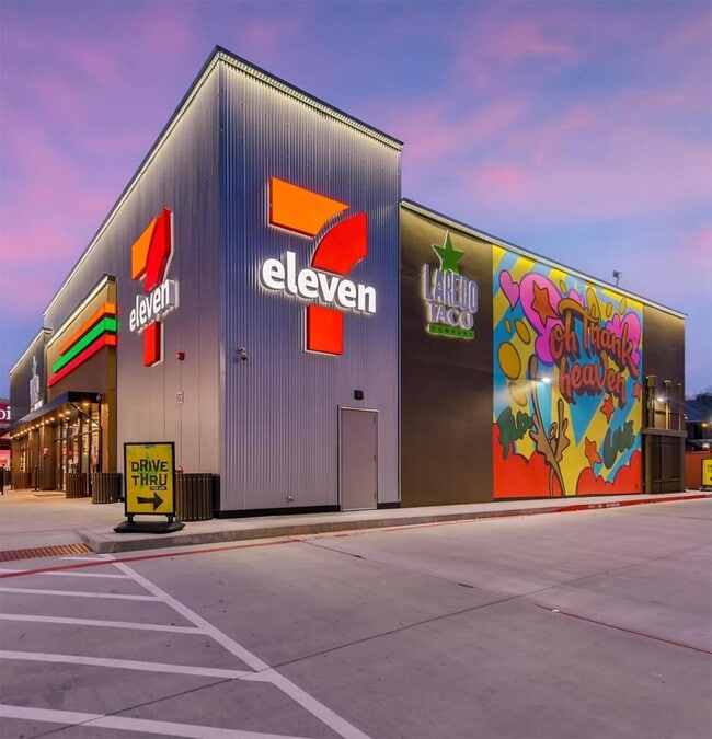
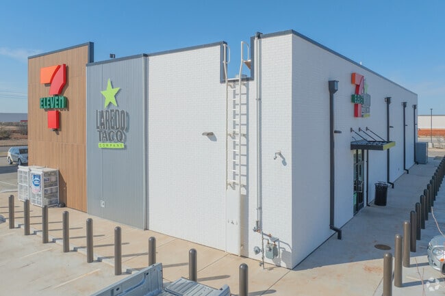
The Grove 7-Eleven
Oklahoma City, OK
THE GROVE 7-ELEVEN BLK 001 LOT 001
218561000
Oklahoma
Storebuilding
Oklahoma
2023
001
2024
1.53 AC
108531
North Outlying
4,794 SF
DEMOGRAPHICS near 17901 N May Ave
1 Mile
3 Mile
5 Mile
2024 Total Population
12,584
61,203
136,572
2029 Population
13,235
63,095
140,191
Pop Growth 2024-2029
+ 5.17%
+ 3.09%
+ 2.65%
Average Age
32
36
37
2024 Total Households
4,266
23,056
55,513
HH Growth 2024-2029
+ 5.30%
+ 3.26%
+ 2.78%
Median Household Inc
$125,447
$97,823
$79,883
Avg Household Size
2.90
2.60
2.40
2024 Avg HH Vehicles
2.00
2.00
2.00
Median Home Value
$272,988
$262,740
$251,546
Median Year Built
2010
2006
1998
Nearby Places
Map Layers
Map Styles
 Street
 Aerial
- Restaurants
- Banks
- Shops
- Fitness
- Groceries
PUBLIC TRANSPORTATION
AIRPORT
Will Rogers World
DRIVE
WALK
Distance
Will Rogers World
32 min
20.8 mi
Freight Ports
Tulsa Port Of Catoosa
DRIVE
WALK
Distance
Tulsa Port Of Catoosa
134 min
122.7 mi
SALE & LEASE HISTORY
LISTING DATE
SALE/LEASE

Sep 07, 2022
For Sale
Nearby Properties
Address
Land Use
TOTAL SIZE
Lot Size
Zoning
Address
Land Use
TOTAL SIZE
Lot Size
Zoning
140,312 SF
7.91 AC
C-3
Address
Land Use
TOTAL SIZE
Lot Size
Zoning
27.22 AC
PUD
Address
Land Use
TOTAL SIZE
Lot Size
Zoning
460,954 SF
24.83 AC
PUD
Address
Land Use
TOTAL SIZE
Lot Size
Zoning
594,334 SF
71.64 AC
C-3
Address
Land Use
TOTAL SIZE
Lot Size
Zoning
41,733 SF
2.63 AC
O-1
Address
Land Use
TOTAL SIZE
Lot Size
Zoning
41,733 SF
2.47 AC
C-3
Address
Land Use
TOTAL SIZE
Lot Size
Zoning
376,079 SF
29.77 AC
PUD
Address
Land Use
TOTAL SIZE
Lot Size
Zoning
8,354 SF
16.65 AC
PUD
Address
Land Use
TOTAL SIZE
Lot Size
Zoning
304,423 SF
31.20 AC
PUD
Address
Land Use
TOTAL SIZE
Lot Size
Zoning
184,238 SF
7.35 AC
C-3
Address
Land Use
TOTAL SIZE
Lot Size
Zoning
10,811 SF
1.46 AC
PUD
Address
Land Use
TOTAL SIZE
Lot Size
Zoning
247,230 SF
22.75 AC
PUD
Address
Land Use
TOTAL SIZE
Lot Size
Zoning
297,836 SF
15 AC
PUD
Address
Land Use
TOTAL SIZE
Lot Size
Zoning
302,058 SF
23.78 AC
PUD
Address
Land Use
TOTAL SIZE
Lot Size
Zoning
227,714 SF
14.15 AC
PUD
Address
Land Use
TOTAL SIZE
Lot Size
Zoning
255,921 SF
9.93 AC
PUD
Address
Land Use
TOTAL SIZE
Lot Size
Zoning
191,504 SF
20.03 AC
PUD
Address
Land Use
TOTAL SIZE
Lot Size
Zoning
235,612 SF
28.09 AC
PUD
Address
Land Use
TOTAL SIZE
Lot Size
Zoning
279,215 SF
11.58 AC
PUD
Address
Land Use
TOTAL SIZE
Lot Size
Zoning
403,628 SF
15.57 AC
C-3
Address
Land Use
TOTAL SIZE
Lot Size
Zoning
140,756 SF
7.93 AC
C-3
Address
Land Use
TOTAL SIZE
Lot Size
Zoning
108,800 SF
7.05 AC
PUD
Address
Land Use
TOTAL SIZE
Lot Size
Zoning
160,416 SF
4.85 AC
PUD
Address
Land Use
TOTAL SIZE
Lot Size
Zoning
131,262 SF
11.34 AC
O-1
Address
Land Use
TOTAL SIZE
Lot Size
Zoning
145,635 SF
12.11 AC
C-3
Address
Land Use
TOTAL SIZE
Lot Size
Zoning
62,580 SF
11.99 AC
C-3
Address
Land Use
TOTAL SIZE
Lot Size
Zoning
150,777 SF
12 AC
C-3
Address
Land Use
TOTAL SIZE
Lot Size
Zoning
151,156 SF
13.71 AC
Address
Land Use
TOTAL SIZE
Lot Size
Zoning
133,880 SF
9.70 AC
R-4
Address
Land Use
TOTAL SIZE
Lot Size
Zoning
2,086 SF
11.67 AC
PUD
The World's #1 Commercial Real Estate Marketplace
Connect with us
© 2025 CoStar Group
The information above has been obtained from sources believed reliable. While we do not doubt its accuracy we have not verified it and make no guarantee, warranty or representation about it. It is your responsibility to independently confirm its accuracy and completeness. Any projections, opinions, assumptions, or estimates used are for example only and do not represent the current or future performance of the property. The value of this transaction to you depends on tax and other factors which should be evaluated by your tax, financial, and legal advisors. You and your advisors should conduct a careful, independent investigation of the property to determine to your satisfaction the suitability of the property for your needs.