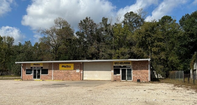
Property Record
17902 Us Highway 59, New Caney, TX 77357

Current Lease Availabilities
Property Detail
17902 Us Highway 59
6500-00-00200
LAIRD, BLOCK 1, LOT 2-5, ACRES 0.780
Commercialnec
Montgomery
5
Texas
B and X Area of moderate flood hazard, usually the area between the limits of the 100-year and 500-year floods.
2-5
2024
0.78 AC
2025
Northeast Hwy 321
692702
Houston
5,400 SF
Houston-Pasadena-The Woodlands, TX
NEARBY LISTINGS FOR SALE OR LEASE
DEMOGRAPHICS near 17902 Us Highway 59
1 mile
3 mile
5 mile
2025 Total Population
2,109
24,067
55,355
2030 Population
2,500
28,842
66,176
Pop Growth 2025-2030
+ 18.54%
+ 19.84%
+ 19.55%
Average Age
40
37
36
2025 Total Households
747
8,102
18,342
HH Growth 2025-2030
+ 19.01%
+ 20.39%
+ 20.18%
Median Household Inc
$92,698
$95,389
$79,595
Avg Household Size
2.80
3.00
3.00
2025 Avg HH Vehicles
3.00
2.00
2.00
Median Home Value
$312,791
$317,978
$279,518
Median Year Built
2002
2010
2007
Nearby Places
Map Layers
Map Styles
 Street
 Aerial
Layers
 Traffic
 Biking
Places
Listings with unknown addresses are not visible on the map
- Restaurants
- Banks
- Shops
- Fitness
- Groceries
PUBLIC TRANSPORTATION
AIRPORT
George Bush Intcntl/Houston
Drive
Walk
Distance
George Bush Intcntl/Houston
26 min
21.9 mi
Freight Ports
Port of Houston
Drive
Walk
Distance
Port of Houston
48 min
37.1 mi
Nearby Properties
Address
Land Use
TOTAL SIZE
Lot Size
Zoning
Address
Land Use
TOTAL SIZE
Lot Size
Zoning
187,696 SF
20.07 AC
Address
Land Use
TOTAL SIZE
Lot Size
Zoning
131,364 SF
4.63 AC
5
Address
Land Use
TOTAL SIZE
Lot Size
Zoning
110,013 SF
13.91 AC
5
Address
Land Use
TOTAL SIZE
Lot Size
Zoning
102,184 SF
20.35 AC
Address
Land Use
TOTAL SIZE
Lot Size
Zoning
54,372 SF
6.26 AC
Address
Land Use
TOTAL SIZE
Lot Size
Zoning
68,756 SF
2.10 AC
Address
Land Use
TOTAL SIZE
Lot Size
Zoning
15,368 SF
12.24 AC
Address
Land Use
TOTAL SIZE
Lot Size
Zoning
20,200 SF
26.46 AC
Address
Land Use
TOTAL SIZE
Lot Size
Zoning
15,000 SF
1.57 AC
Address
Land Use
TOTAL SIZE
Lot Size
Zoning
55,676 SF
5.40 AC
5
Address
Land Use
TOTAL SIZE
Lot Size
Zoning
3,597 SF
17.87 AC
Address
Land Use
TOTAL SIZE
Lot Size
Zoning
48,405 SF
30.58 AC
5
Address
Land Use
TOTAL SIZE
Lot Size
Zoning
15,638 SF
17.29 AC
5
Address
Land Use
TOTAL SIZE
Lot Size
Zoning
62,486 SF
3.53 AC
5
Address
Land Use
TOTAL SIZE
Lot Size
Zoning
18.30 AC
Address
Land Use
TOTAL SIZE
Lot Size
Zoning
77,118 SF
5.64 AC
5
Address
Land Use
TOTAL SIZE
Lot Size
Zoning
3,880 SF
13.32 AC
5
Address
Land Use
TOTAL SIZE
Lot Size
Zoning
13,420 SF
7.82 AC
5
Address
Land Use
TOTAL SIZE
Lot Size
Zoning
5,900 SF
2.97 AC
Address
Land Use
TOTAL SIZE
Lot Size
Zoning
14,250 SF
1.08 AC
Address
Land Use
TOTAL SIZE
Lot Size
Zoning
70,376 SF
11.21 AC
5
Address
Land Use
TOTAL SIZE
Lot Size
Zoning
1,344 SF
11.36 AC
5
Address
Land Use
TOTAL SIZE
Lot Size
Zoning
8,432 SF
2.87 AC
Address
Land Use
TOTAL SIZE
Lot Size
Zoning
48,400 SF
4.14 AC
Address
Land Use
TOTAL SIZE
Lot Size
Zoning
19,587 SF
3.50 AC
The World's #1 Commercial Real Estate Marketplace
Connect with us
© 2026 CoStar Group
The information above has been obtained from sources believed reliable. While we do not doubt its accuracy we have not verified it and make no guarantee, warranty or representation about it. It is your responsibility to independently confirm its accuracy and completeness. Any projections, opinions, assumptions, or estimates used are for example only and do not represent the current or future performance of the property. The value of this transaction to you depends on tax and other factors which should be evaluated by your tax, financial, and legal advisors. You and your advisors should conduct a careful, independent investigation of the property to determine to your satisfaction the suitability of the property for your needs.