Property Record
17905 Walter P Chrysler Fwy, Highland Park, MI 48203
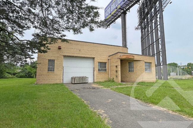

This Property Is For Sale
NEARBY LISTINGS FOR SALE OR LEASE
Property Detail
17905 Walter P Chrysler Fwy
09-020505
Kiefer Homes
Manufacturinglight
W CHRYSLER FWY 421 EXC TRIANG PT BG W 27.86 FT ON N LINE & N 51.33 FT ON W LINE 422&423 KIEFER HOMES SUB L34 P14 PLATS, W C R 9/164 12,812 SQ FT
X
Wayne
26163C0125E
Michigan
2025
0.29 AC
2025
Detroit West
509000
Detroit
3,270 SF
Detroit-Warren-Dearborn, MI
DEMOGRAPHICS near 17905 Walter P Chrysler Fwy
1 Mile
3 Mile
5 Mile
2024 Total Population
13,076
152,977
392,782
2029 Population
13,511
152,436
392,031
Pop Growth 2024-2029
+ 3.33%
(0.35%)
(0.19%)
Average Age
39
38
38
2024 Total Households
5,371
59,516
159,520
HH Growth 2024-2029
+ 3.26%
(0.06%)
(0.04%)
Median Household Inc
$37,352
$39,983
$41,069
Avg Household Size
2.40
2.50
2.40
2024 Avg HH Vehicles
1.00
1.00
1.00
Median Home Value
$66,804
$93,559
$103,916
Median Year Built
1949
1948
1949
Nearby Places
Map Layers
Map Styles
 Street
 Aerial
- Restaurants
- Banks
- Shops
- Fitness
- Groceries
PUBLIC TRANSPORTATION
COMMUTER RAIL
DRIVE
WALK
Distance
9 min
4.9 mi
DRIVE
WALK
Distance
13 min
7.7 mi
AIRPORT
Windsor International
DRIVE
WALK
Distance
Windsor International
33 min
16.7 mi
Detroit Metro Wayne County
DRIVE
WALK
Distance
Detroit Metro Wayne County
38 min
26.3 mi
Nearby Properties
Address
Land Use
TOTAL SIZE
Lot Size
Zoning
Address
Land Use
TOTAL SIZE
Lot Size
Zoning
3,529,575 SF
84.46 AC
B4
Address
Land Use
TOTAL SIZE
Lot Size
Zoning
331,559 SF
11.42 AC
M4
Address
Land Use
TOTAL SIZE
Lot Size
Zoning
564,958 SF
9.69 AC
M4
Address
Land Use
TOTAL SIZE
Lot Size
Zoning
259,959 SF
27.39 AC
MZ
Address
Land Use
TOTAL SIZE
Lot Size
Zoning
199,592 SF
17.02 AC
B3
Address
Land Use
TOTAL SIZE
Lot Size
Zoning
103,320 SF
Address
Land Use
TOTAL SIZE
Lot Size
Zoning
303,615 SF
22.07 AC
MZ
Address
Land Use
TOTAL SIZE
Lot Size
Zoning
446,500 SF
27.90 AC
Address
Land Use
TOTAL SIZE
Lot Size
Zoning
123,844 SF
1.81 AC
R2
Address
Land Use
TOTAL SIZE
Lot Size
Zoning
156,250 SF
8.79 AC
B4
Address
Land Use
TOTAL SIZE
Lot Size
Zoning
180,056 SF
1.45 AC
II
Address
Land Use
TOTAL SIZE
Lot Size
Zoning
119,418 SF
13.81 AC
B4
Address
Land Use
TOTAL SIZE
Lot Size
Zoning
292,032 SF
20.25 AC
B4
Address
Land Use
TOTAL SIZE
Lot Size
Zoning
116,060 SF
6.95 AC
R2
Address
Land Use
TOTAL SIZE
Lot Size
Zoning
353,800 SF
15.70 AC
Address
Land Use
TOTAL SIZE
Lot Size
Zoning
301,000 SF
Address
Land Use
TOTAL SIZE
Lot Size
Zoning
150,689 SF
4.87 AC
R5
Address
Land Use
TOTAL SIZE
Lot Size
Zoning
181,798 SF
10.48 AC
B4
Address
Land Use
TOTAL SIZE
Lot Size
Zoning
90,595 SF
8.20 AC
BI
Address
Land Use
TOTAL SIZE
Lot Size
Zoning
23,852 SF
130.56 AC
R1
Address
Land Use
TOTAL SIZE
Lot Size
Zoning
2,216,908 SF
44.80 AC
Address
Land Use
TOTAL SIZE
Lot Size
Zoning
217,000 SF
11.91 AC
Address
Land Use
TOTAL SIZE
Lot Size
Zoning
224,519 SF
9.98 AC
Address
Land Use
TOTAL SIZE
Lot Size
Zoning
110,000 SF
1.36 AC
Address
Land Use
TOTAL SIZE
Lot Size
Zoning
147,717 SF
8.61 AC
PD
Address
Land Use
TOTAL SIZE
Lot Size
Zoning
7.10 AC
Address
Land Use
TOTAL SIZE
Lot Size
Zoning
300,000 SF
17.73 AC
Address
Land Use
TOTAL SIZE
Lot Size
Zoning
91,233 SF
11.36 AC
Address
Land Use
TOTAL SIZE
Lot Size
Zoning
135,520 SF
8.78 AC
R-3
Address
Land Use
TOTAL SIZE
Lot Size
Zoning
The World's #1 Commercial Real Estate Marketplace
Connect with us
© 2026 CoStar Group
The information above has been obtained from sources believed reliable. While we do not doubt its accuracy we have not verified it and make no guarantee, warranty or representation about it. It is your responsibility to independently confirm its accuracy and completeness. Any projections, opinions, assumptions, or estimates used are for example only and do not represent the current or future performance of the property. The value of this transaction to you depends on tax and other factors which should be evaluated by your tax, financial, and legal advisors. You and your advisors should conduct a careful, independent investigation of the property to determine to your satisfaction the suitability of the property for your needs.