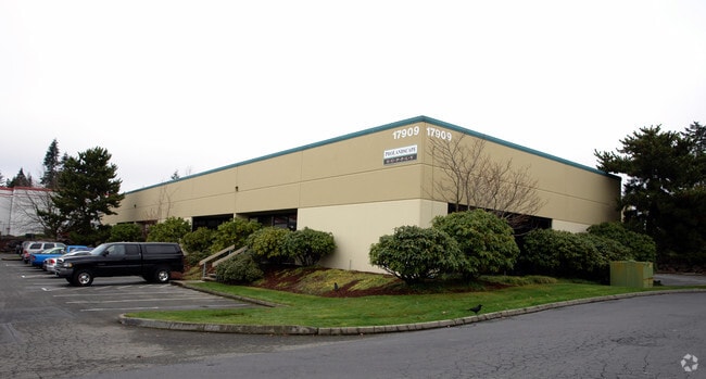
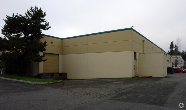
Property Record
17909 Bothell Everett Hwy, Bothell, WA 98012


Property Detail
17909 Bothell Everett Hwy
270507-004-047-00
SECTION 07 TOWNSHIP 27 RANGE 05 QUARTER SE LOT 5 SNO CO PFN 04-116554SP REC AFN 200412095275 BEING A PTN OF SE1/4 SE1/4
Commercialnec
Snohomish
LI
Washington
B and X Area of moderate flood hazard, usually the area between the limits of the 100-year and 500-year floods.
5
2025
0.94 AC
2026
Mill Creek/N Creek
052007
Seattle/Puget Sound
14,662 SF
Seattle-Tacoma-Bellevue, WA
NEARBY LISTINGS FOR SALE OR LEASE
DEMOGRAPHICS near 17909 Bothell Everett Hwy
1 mile
3 mile
5 mile
2024 Total Population
16,577
131,554
352,792
2029 Population
17,089
137,322
367,684
Pop Growth 2024-2029
+ 3.09%
+ 4.38%
+ 4.22%
Average Age
37
38
38
2024 Total Households
5,836
46,645
129,041
HH Growth 2024-2029
+ 3.22%
+ 4.50%
+ 4.32%
Median Household Inc
$147,545
$139,764
$120,998
Avg Household Size
2.80
2.80
2.70
2024 Avg HH Vehicles
2.00
2.00
2.00
Median Home Value
$788,647
$822,038
$781,330
Median Year Built
1992
2000
1994
Nearby Places
Map Layers
Map Styles
 Street
 Aerial
Transit
 Traffic
 Biking
Places
Listings with unknown addresses are not visible on the map
- Restaurants
- Banks
- Shops
- Fitness
- Groceries
PUBLIC TRANSPORTATION
AIRPORT
Seattle Paine Field International
Drive
Walk
Distance
Seattle Paine Field International
18 min
8.1 mi
Seattle-Tacoma International
Drive
Walk
Distance
Seattle-Tacoma International
49 min
33.6 mi
Freight Ports
Port of Everett
Drive
Walk
Distance
Port of Everett
23 min
12.1 mi
Nearby Properties
Address
Land Use
TOTAL SIZE
Lot Size
Zoning
Address
Land Use
TOTAL SIZE
Lot Size
Zoning
581,232 SF
43.22 AC
UC
Address
Land Use
TOTAL SIZE
Lot Size
Zoning
329,964 SF
20.07 AC
MR
Address
Land Use
TOTAL SIZE
Lot Size
Zoning
426,238 SF
9.84 AC
UC
Address
Land Use
TOTAL SIZE
Lot Size
Zoning
619,673 SF
0.34 AC
UC
Address
Land Use
TOTAL SIZE
Lot Size
Zoning
375,816 SF
40.36 AC
MU/HDR
Address
Land Use
TOTAL SIZE
Lot Size
Zoning
524,803 SF
PRC
Address
Land Use
TOTAL SIZE
Lot Size
Zoning
372,073 SF
9.11 AC
UC
Address
Land Use
TOTAL SIZE
Lot Size
Zoning
217,071 SF
36.47 AC
R-9,600
Address
Land Use
TOTAL SIZE
Lot Size
Zoning
233,025 SF
3.97 AC
R-9,600
Address
Land Use
TOTAL SIZE
Lot Size
Zoning
285,554 SF
15 AC
HDR
Address
Land Use
TOTAL SIZE
Lot Size
Zoning
241,956 SF
20 AC
HDR
Address
Land Use
TOTAL SIZE
Lot Size
Zoning
262,618 SF
7.05 AC
MU/HDR
Address
Land Use
TOTAL SIZE
Lot Size
Zoning
386,535 SF
2.21 AC
UC
Address
Land Use
TOTAL SIZE
Lot Size
Zoning
394,152 SF
18 AC
E-M
Address
Land Use
TOTAL SIZE
Lot Size
Zoning
250,800 SF
11.69 AC
UC
Address
Land Use
TOTAL SIZE
Lot Size
Zoning
181,008 SF
9.76 AC
E-L
Address
Land Use
TOTAL SIZE
Lot Size
Zoning
57.84 AC
R-9,600
Address
Land Use
TOTAL SIZE
Lot Size
Zoning
291,349 SF
12.42 AC
MU/HDR
Address
Land Use
TOTAL SIZE
Lot Size
Zoning
47,176 SF
38.88 AC
R 9,600
Address
Land Use
TOTAL SIZE
Lot Size
Zoning
236,844 SF
9.02 AC
CB
Address
Land Use
TOTAL SIZE
Lot Size
Zoning
213,689 SF
7.46 AC
UC
Address
Land Use
TOTAL SIZE
Lot Size
Zoning
864 SF
42.79 AC
LDR
Address
Land Use
TOTAL SIZE
Lot Size
Zoning
177,325 SF
20.54 AC
R-9,600
Address
Land Use
TOTAL SIZE
Lot Size
Zoning
195,366 SF
10.66 AC
MR
Address
Land Use
TOTAL SIZE
Lot Size
Zoning
243,504 SF
13.84 AC
CB
Address
Land Use
TOTAL SIZE
Lot Size
Zoning
189,700 SF
18.85 AC
OR-L
Address
Land Use
TOTAL SIZE
Lot Size
Zoning
19,041 SF
8.17 AC
MR
Address
Land Use
TOTAL SIZE
Lot Size
Zoning
283,224 SF
16.87 AC
MR
Address
Land Use
TOTAL SIZE
Lot Size
Zoning
173,130 SF
10.27 AC
E-L
Address
Land Use
TOTAL SIZE
Lot Size
Zoning
177,300 SF
15.50 AC
OR-M
The World's #1 Commercial Real Estate Marketplace
Connect with us
© 2026 CoStar Group
The information above has been obtained from sources believed reliable. While we do not doubt its accuracy we have not verified it and make no guarantee, warranty or representation about it. It is your responsibility to independently confirm its accuracy and completeness. Any projections, opinions, assumptions, or estimates used are for example only and do not represent the current or future performance of the property. The value of this transaction to you depends on tax and other factors which should be evaluated by your tax, financial, and legal advisors. You and your advisors should conduct a careful, independent investigation of the property to determine to your satisfaction the suitability of the property for your needs.