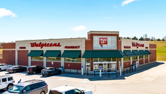
Property Record
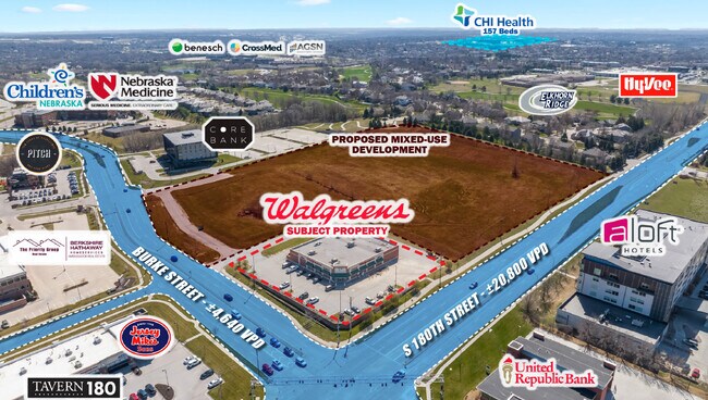
17909 Burke St, Omaha, NE 68118

NEARBY LISTINGS FOR SALE OR LEASE
Property Detail
17909 Burke St
Omaha/Council Bluffs
West Village Pointe
Omaha-Council Bluffs, NE-IA
WEST VILLAGE POINTE REPLAT 4* LOT 1 BLOCK 0 IRREG 63335 SQ FT
3122-0490-25
Douglas
Storebuilding
Nebraska
2024
1
2025
1.45 AC
007524
West Dodge Corridor
14,736 SF
DEMOGRAPHICS near 17909 Burke St
1 Mile
3 Mile
5 Mile
2024 Total Population
5,581
76,244
185,113
2029 Population
5,610
77,169
187,809
Pop Growth 2024-2029
+ 0.52%
+ 1.21%
+ 1.46%
Average Age
41
38
39
2024 Total Households
2,326
27,851
68,374
HH Growth 2024-2029
+ 0.52%
+ 1.22%
+ 1.44%
Median Household Inc
$133,091
$120,820
$112,444
Avg Household Size
2.40
2.70
2.70
2024 Avg HH Vehicles
2.00
2.00
2.00
Median Home Value
$389,431
$320,312
$292,975
Median Year Built
2007
2000
1998
Nearby Places
Map Layers
Map Styles
 Street
 Aerial
- Restaurants
- Banks
- Shops
- Fitness
- Groceries
PUBLIC TRANSPORTATION
AIRPORT
Eppley Airfield
DRIVE
WALK
Distance
Eppley Airfield
35 min
18.1 mi
Freight Ports
Tulsa Port Of Catoosa
DRIVE
WALK
Distance
Tulsa Port Of Catoosa
482 min
432.5 mi
SALE & LEASE HISTORY
LISTING DATE
SALE/LEASE

Jul 12, 2023
For Sale
Apr 23, 2024
For Sale
Nearby Properties
Address
Land Use
TOTAL SIZE
Lot Size
Zoning
Address
Land Use
TOTAL SIZE
Lot Size
Zoning
443,045 SF
22.82 AC
Address
Land Use
TOTAL SIZE
Lot Size
Zoning
486,568 SF
51.70 AC
ELKHORN
Address
Land Use
TOTAL SIZE
Lot Size
Zoning
420,483 SF
18.51 AC
R6
Address
Land Use
TOTAL SIZE
Lot Size
Zoning
449,891 SF
11.32 AC
Address
Land Use
TOTAL SIZE
Lot Size
Zoning
410,657 SF
18.25 AC
Address
Land Use
TOTAL SIZE
Lot Size
Zoning
362,573 SF
2.01 AC
Address
Land Use
TOTAL SIZE
Lot Size
Zoning
186,653 SF
7.96 AC
Address
Land Use
TOTAL SIZE
Lot Size
Zoning
223,975 SF
11.91 AC
Address
Land Use
TOTAL SIZE
Lot Size
Zoning
369,614 SF
18.03 AC
CC
Address
Land Use
TOTAL SIZE
Lot Size
Zoning
299,172 SF
13.80 AC
R7
Address
Land Use
TOTAL SIZE
Lot Size
Zoning
264,001 SF
10.33 AC
Address
Land Use
TOTAL SIZE
Lot Size
Zoning
114,840 SF
4.50 AC
Address
Land Use
TOTAL SIZE
Lot Size
Zoning
104,473 SF
0.78 AC
MU
Address
Land Use
TOTAL SIZE
Lot Size
Zoning
240,630 SF
5.38 AC
Address
Land Use
TOTAL SIZE
Lot Size
Zoning
241,312 SF
14.51 AC
Address
Land Use
TOTAL SIZE
Lot Size
Zoning
226,792 SF
8.97 AC
GO
Address
Land Use
TOTAL SIZE
Lot Size
Zoning
88,928 SF
6.17 AC
Address
Land Use
TOTAL SIZE
Lot Size
Zoning
226,780 SF
8.23 AC
Address
Land Use
TOTAL SIZE
Lot Size
Zoning
341,379 SF
18.08 AC
Address
Land Use
TOTAL SIZE
Lot Size
Zoning
232,559 SF
13.53 AC
R6
Address
Land Use
TOTAL SIZE
Lot Size
Zoning
215,645 SF
5.19 AC
Address
Land Use
TOTAL SIZE
Lot Size
Zoning
376,653 SF
7.36 AC
Address
Land Use
TOTAL SIZE
Lot Size
Zoning
233,520 SF
15.39 AC
Address
Land Use
TOTAL SIZE
Lot Size
Zoning
355,421 SF
18.66 AC
Address
Land Use
TOTAL SIZE
Lot Size
Zoning
121,017 SF
13.23 AC
Address
Land Use
TOTAL SIZE
Lot Size
Zoning
168,896 SF
8.79 AC
MU
Address
Land Use
TOTAL SIZE
Lot Size
Zoning
222,090 SF
7.74 AC
R6
Address
Land Use
TOTAL SIZE
Lot Size
Zoning
144,271 SF
4.75 AC
Address
Land Use
TOTAL SIZE
Lot Size
Zoning
137,800 SF
6.69 AC
The World's #1 Commercial Real Estate Marketplace
Connect with us
© 2025 CoStar Group
The information above has been obtained from sources believed reliable. While we do not doubt its accuracy we have not verified it and make no guarantee, warranty or representation about it. It is your responsibility to independently confirm its accuracy and completeness. Any projections, opinions, assumptions, or estimates used are for example only and do not represent the current or future performance of the property. The value of this transaction to you depends on tax and other factors which should be evaluated by your tax, financial, and legal advisors. You and your advisors should conduct a careful, independent investigation of the property to determine to your satisfaction the suitability of the property for your needs.