Property Record
1791 Erringer Rd, Simi Valley, CA 93065
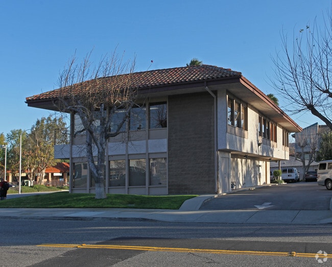

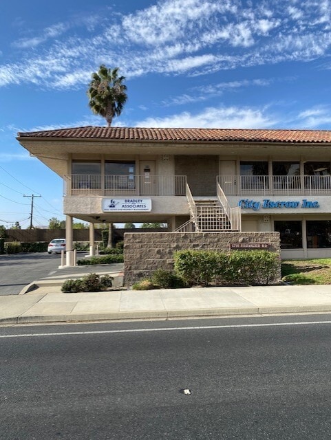
Property Detail
1791 Erringer Rd
632-0-050-175
MAP 16 PG 8-1 LOT 3
Officebuilding
Ventura
CPD
California
B and X Area of moderate flood hazard, usually the area between the limits of the 100-year and 500-year floods.
0.32 AC
2024
Moorpark/Simi Valley
2025
Los Angeles
007800
Oxnard-Thousand Oaks-Ventura, CA
4,818 SF
NEARBY LISTINGS FOR SALE OR LEASE
DEMOGRAPHICS near 1791 Erringer Rd
1 mile
3 mile
5 mile
2024 Total Population
23,894
82,295
118,931
2029 Population
23,725
81,538
117,771
Pop Growth 2024-2029
(0.71%)
(0.92%)
(0.98%)
Average Age
39
41
42
2024 Total Households
7,261
26,924
40,010
HH Growth 2024-2029
(0.80%)
(1.14%)
(1.20%)
Median Household Inc
$96,937
$114,861
$120,654
Avg Household Size
3.10
2.90
2.90
2024 Avg HH Vehicles
2.00
2.00
2.00
Median Home Value
$724,718
$784,036
$798,631
Median Year Built
1968
1977
1980
Nearby Places
Map Layers
Map Styles
 Street
 Aerial
Transit
 Traffic
 Biking
Places
Listings with unknown addresses are not visible on the map
- Restaurants
- Banks
- Shops
- Fitness
- Groceries
PUBLIC TRANSPORTATION
COMMUTER RAIL
Simi Valley (Ventura County Line - Southern California Regional Rail Authority (Metrolink))
Drive
Walk
Distance
Simi Valley (Ventura County Line - Southern California Regional Rail Authority (Metrolink))
7 min
4.0 mi
Moorpark (Ventura County Line - Southern California Regional Rail Authority (Metrolink))
Drive
Walk
Distance
Moorpark (Ventura County Line - Southern California Regional Rail Authority (Metrolink))
14 min
9.5 mi
AIRPORT
Bob Hope
Drive
Walk
Distance
Bob Hope
35 min
27.4 mi
Los Angeles International
Drive
Walk
Distance
Los Angeles International
55 min
43.3 mi
SALE & LEASE HISTORY
LISTING DATE
SALE/LEASE

Sep 09, 2024
For Lease
Nov 12, 2021
For Sale
Feb 26, 2024
For Lease
Dec 21, 2020
For Lease
Aug 05, 2024
For Sale
Nearby Properties
Address
Land Use
TOTAL SIZE
Lot Size
Zoning
Address
Land Use
TOTAL SIZE
Lot Size
Zoning
4.77 AC
CO
Address
Land Use
TOTAL SIZE
Lot Size
Zoning
286,132 SF
15.07 AC
RVH-.
Address
Land Use
TOTAL SIZE
Lot Size
Zoning
28,561 SF
43.55 AC
BP-S
Address
Land Use
TOTAL SIZE
Lot Size
Zoning
45,594 SF
15.99 AC
RVH-2
Address
Land Use
TOTAL SIZE
Lot Size
Zoning
265,102 SF
12.30 AC
Address
Land Use
TOTAL SIZE
Lot Size
Zoning
238,578 SF
10.85 AC
Address
Land Use
TOTAL SIZE
Lot Size
Zoning
57,707 SF
14.76 AC
L-I
Address
Land Use
TOTAL SIZE
Lot Size
Zoning
18,057 SF
10.23 AC
L-I
Address
Land Use
TOTAL SIZE
Lot Size
Zoning
276,943 SF
24.62 AC
RVH-
Address
Land Use
TOTAL SIZE
Lot Size
Zoning
71,166 SF
12.44 AC
GI
Address
Land Use
TOTAL SIZE
Lot Size
Zoning
25,277 SF
14.64 AC
RM-3
Address
Land Use
TOTAL SIZE
Lot Size
Zoning
21,873 SF
17.04 AC
Address
Land Use
TOTAL SIZE
Lot Size
Zoning
20,461 SF
2.92 AC
Address
Land Use
TOTAL SIZE
Lot Size
Zoning
14.66 AC
Address
Land Use
TOTAL SIZE
Lot Size
Zoning
3.15 AC
RL-1
Address
Land Use
TOTAL SIZE
Lot Size
Zoning
18,820 SF
11.46 AC
Address
Land Use
TOTAL SIZE
Lot Size
Zoning
157,745 SF
7.53 AC
L-I
Address
Land Use
TOTAL SIZE
Lot Size
Zoning
89,902 SF
4.03 AC
Address
Land Use
TOTAL SIZE
Lot Size
Zoning
14,120 SF
8.22 AC
Address
Land Use
TOTAL SIZE
Lot Size
Zoning
159,664 SF
7.50 AC
L-I
Address
Land Use
TOTAL SIZE
Lot Size
Zoning
20,660 SF
8.15 AC
Address
Land Use
TOTAL SIZE
Lot Size
Zoning
66,724 SF
2.83 AC
Address
Land Use
TOTAL SIZE
Lot Size
Zoning
18,889 SF
10.29 AC
A1
Address
Land Use
TOTAL SIZE
Lot Size
Zoning
13,585 SF
8.28 AC
BP-S
Address
Land Use
TOTAL SIZE
Lot Size
Zoning
Address
Land Use
TOTAL SIZE
Lot Size
Zoning
157,065 SF
4.30 AC
Address
Land Use
TOTAL SIZE
Lot Size
Zoning
Address
Land Use
TOTAL SIZE
Lot Size
Zoning
10,368 SF
13.36 AC
The World's #1 Commercial Real Estate Marketplace
Connect with us
© 2026 CoStar Group
The information above has been obtained from sources believed reliable. While we do not doubt its accuracy we have not verified it and make no guarantee, warranty or representation about it. It is your responsibility to independently confirm its accuracy and completeness. Any projections, opinions, assumptions, or estimates used are for example only and do not represent the current or future performance of the property. The value of this transaction to you depends on tax and other factors which should be evaluated by your tax, financial, and legal advisors. You and your advisors should conduct a careful, independent investigation of the property to determine to your satisfaction the suitability of the property for your needs.