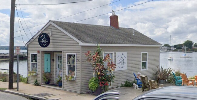
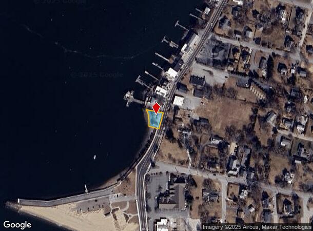
Property Record
1791 Main Rd, Tiverton, RI 02878
NEARBY LISTINGS FOR SALE OR LEASE
Property Detail
1791 Main Rd
TIVE-000305-000000-000108
Newport
Commercialnec
Rhode Island
VE
0.10 AC
44005C0039J
Newport County
2025
Providence
2025
Providence-Warwick, RI-MA
041602
DEMOGRAPHICS near 1791 Main Rd
1 Mile
3 Mile
5 Mile
2024 Total Population
2,188
15,728
66,408
2029 Population
2,152
15,464
65,342
Pop Growth 2024-2029
(1.65%)
(1.68%)
(1.61%)
Average Age
47
47
43
2024 Total Households
967
6,628
27,318
HH Growth 2024-2029
(1.96%)
(1.92%)
(1.70%)
Median Household Inc
$90,693
$95,918
$78,033
Avg Household Size
2.20
2.30
2.30
2024 Avg HH Vehicles
2.00
2.00
2.00
Median Home Value
$499,999
$404,414
$388,335
Median Year Built
1954
1965
1960
Nearby Places
Map Layers
Map Styles
 Street
 Aerial
- Restaurants
- Banks
- Shops
- Fitness
- Groceries
PUBLIC TRANSPORTATION
AIRPORT
Rhode Island Tf Green International
DRIVE
WALK
Distance
Rhode Island Tf Green International
45 min
29.7 mi
Freight Ports
Port of New Bedford Harbor
DRIVE
WALK
Distance
Port of New Bedford Harbor
26 min
19.0 mi
SALE & LEASE HISTORY
LISTING DATE
SALE/LEASE

Dec 01, 2023
For Lease
Nearby Properties
Address
Land Use
TOTAL SIZE
Lot Size
Zoning
Address
Land Use
TOTAL SIZE
Lot Size
Zoning
27.66 AC
I
Address
Land Use
TOTAL SIZE
Lot Size
Zoning
42 AC
R20
Address
Land Use
TOTAL SIZE
Lot Size
Zoning
150,156 SF
8.77 AC
R40
Address
Land Use
TOTAL SIZE
Lot Size
Zoning
3,512 SF
30.88 AC
EI
Address
Land Use
TOTAL SIZE
Lot Size
Zoning
124,038 SF
74.50 AC
R60
Address
Land Use
TOTAL SIZE
Lot Size
Zoning
178,538 SF
17.27 AC
I
Address
Land Use
TOTAL SIZE
Lot Size
Zoning
144,773 SF
10.50 AC
R60
Address
Land Use
TOTAL SIZE
Lot Size
Zoning
10 AC
HC
Address
Land Use
TOTAL SIZE
Lot Size
Zoning
74,293 SF
10.77 AC
TC
Address
Land Use
TOTAL SIZE
Lot Size
Zoning
84,000 SF
3.31 AC
I
Address
Land Use
TOTAL SIZE
Lot Size
Zoning
48,351 SF
10.75 AC
R20
Address
Land Use
TOTAL SIZE
Lot Size
Zoning
78,182 SF
10 AC
R10
Address
Land Use
TOTAL SIZE
Lot Size
Zoning
33,916 SF
5.75 AC
TC
Address
Land Use
TOTAL SIZE
Lot Size
Zoning
2.79 AC
R10
Address
Land Use
TOTAL SIZE
Lot Size
Zoning
2.81 AC
C
Address
Land Use
TOTAL SIZE
Lot Size
Zoning
3.34 AC
GC
Address
Land Use
TOTAL SIZE
Lot Size
Zoning
4,850 SF
26.29 AC
W
Address
Land Use
TOTAL SIZE
Lot Size
Zoning
7,179 SF
9.50 AC
R-40
Address
Land Use
TOTAL SIZE
Lot Size
Zoning
4.50 AC
R20
Address
Land Use
TOTAL SIZE
Lot Size
Zoning
229.01 AC
OS
Address
Land Use
TOTAL SIZE
Lot Size
Zoning
35,250 SF
R30
Address
Land Use
TOTAL SIZE
Lot Size
Zoning
107.70 AC
R10
Address
Land Use
TOTAL SIZE
Lot Size
Zoning
9.93 AC
GC
Address
Land Use
TOTAL SIZE
Lot Size
Zoning
2,016 SF
25.73 AC
R40
Address
Land Use
TOTAL SIZE
Lot Size
Zoning
44.64 AC
I
Address
Land Use
TOTAL SIZE
Lot Size
Zoning
26.01 AC
HI
Address
Land Use
TOTAL SIZE
Lot Size
Zoning
21.80 AC
R20
Address
Land Use
TOTAL SIZE
Lot Size
Zoning
14,306 SF
1.15 AC
GC
Address
Land Use
TOTAL SIZE
Lot Size
Zoning
5 AC
R80
Address
Land Use
TOTAL SIZE
Lot Size
Zoning
16,420 SF
1.79 AC
R40
The World's #1 Commercial Real Estate Marketplace
Connect with us
© 2026 CoStar Group
The information above has been obtained from sources believed reliable. While we do not doubt its accuracy we have not verified it and make no guarantee, warranty or representation about it. It is your responsibility to independently confirm its accuracy and completeness. Any projections, opinions, assumptions, or estimates used are for example only and do not represent the current or future performance of the property. The value of this transaction to you depends on tax and other factors which should be evaluated by your tax, financial, and legal advisors. You and your advisors should conduct a careful, independent investigation of the property to determine to your satisfaction the suitability of the property for your needs.