Property Record
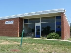
17920 Us Highway 64 W, Siler City, NC 27344


NEARBY LISTINGS FOR SALE OR LEASE
Property Detail
17920 Us Highway 64 W
13056
Hwy 64 West (Apartments)
Realpropertynec
B5-207 AC 1.206 BK 2002 PG 292
X
Chatham
3710874200J
North Carolina
2025
1.21 AC
2025
Chatham County
020402
Raleigh/Durham
14,517 SF
Durham-Chapel Hill, NC
DEMOGRAPHICS near 17920 Us Highway 64 W
1 Mile
3 Mile
5 Mile
2024 Total Population
2,322
10,685
14,208
2029 Population
2,635
11,991
15,873
Pop Growth 2024-2029
+ 13.48%
+ 12.22%
+ 11.72%
Average Age
37
39
39
2024 Total Households
818
3,887
5,254
HH Growth 2024-2029
+ 13.81%
+ 12.45%
+ 11.91%
Median Household Inc
$69,621
$36,736
$39,014
Avg Household Size
2.70
2.70
2.60
2024 Avg HH Vehicles
2.00
2.00
2.00
Median Home Value
$138,743
$142,541
$144,797
Median Year Built
1991
1979
1981
Nearby Places
Map Layers
Map Styles
 Street
 Aerial
- Restaurants
- Banks
- Shops
- Fitness
- Groceries
PUBLIC TRANSPORTATION
AIRPORT
Piedmont Triad International
DRIVE
WALK
Distance
Piedmont Triad International
61 min
46.7 mi
Nearby Properties
Address
Land Use
TOTAL SIZE
Lot Size
Zoning
Address
Land Use
TOTAL SIZE
Lot Size
Zoning
284,650 SF
37.55 AC
H-I
Address
Land Use
TOTAL SIZE
Lot Size
Zoning
225,615 SF
11.05 AC
H-I
Address
Land Use
TOTAL SIZE
Lot Size
Zoning
713.27 AC
SCETJ
Address
Land Use
TOTAL SIZE
Lot Size
Zoning
364,431 SF
45.55 AC
H-I
Address
Land Use
TOTAL SIZE
Lot Size
Zoning
149,304 SF
18.18 AC
R-10
Address
Land Use
TOTAL SIZE
Lot Size
Zoning
22,416 SF
11.20 AC
R-6
Address
Land Use
TOTAL SIZE
Lot Size
Zoning
47,727 SF
10.71 AC
H-C
Address
Land Use
TOTAL SIZE
Lot Size
Zoning
2,480 SF
13.30 AC
R-6
Address
Land Use
TOTAL SIZE
Lot Size
Zoning
7,280 SF
10.14 AC
R-10
Address
Land Use
TOTAL SIZE
Lot Size
Zoning
1,176 SF
8.01 AC
R-10
Address
Land Use
TOTAL SIZE
Lot Size
Zoning
10,280 SF
24.48 AC
H-I
Address
Land Use
TOTAL SIZE
Lot Size
Zoning
24,034 SF
75.66 AC
A-R
Address
Land Use
TOTAL SIZE
Lot Size
Zoning
2,480 SF
10.01 AC
SCETJ
Address
Land Use
TOTAL SIZE
Lot Size
Zoning
30,660 SF
18.64 AC
L-I
Address
Land Use
TOTAL SIZE
Lot Size
Zoning
14,704 SF
1.61 AC
H-C
Address
Land Use
TOTAL SIZE
Lot Size
Zoning
65.59 AC
A-R
Address
Land Use
TOTAL SIZE
Lot Size
Zoning
8,923 SF
20.75 AC
SCETJ
Address
Land Use
TOTAL SIZE
Lot Size
Zoning
72,499 SF
5.53 AC
L-I
Address
Land Use
TOTAL SIZE
Lot Size
Zoning
43,927 SF
6.64 AC
O-I
Address
Land Use
TOTAL SIZE
Lot Size
Zoning
31,436 SF
5.36 AC
O-I
Address
Land Use
TOTAL SIZE
Lot Size
Zoning
19,384 SF
14.95 AC
R-20
Address
Land Use
TOTAL SIZE
Lot Size
Zoning
11,934 SF
24.12 AC
L-I
Address
Land Use
TOTAL SIZE
Lot Size
Zoning
135.57 AC
H-I
Address
Land Use
TOTAL SIZE
Lot Size
Zoning
129.52 AC
H-I
Address
Land Use
TOTAL SIZE
Lot Size
Zoning
85,596 SF
35.13 AC
H-I
Address
Land Use
TOTAL SIZE
Lot Size
Zoning
10,125 SF
1.79 AC
H-C
Address
Land Use
TOTAL SIZE
Lot Size
Zoning
119,044 SF
8.31 AC
L-I
Address
Land Use
TOTAL SIZE
Lot Size
Zoning
225,524 SF
21.60 AC
H-I
Address
Land Use
TOTAL SIZE
Lot Size
Zoning
70,882 SF
7.81 AC
H-C
Address
Land Use
TOTAL SIZE
Lot Size
Zoning
82,687 SF
13.51 AC
L-I
The World's #1 Commercial Real Estate Marketplace
Connect with us
© 2026 CoStar Group
The information above has been obtained from sources believed reliable. While we do not doubt its accuracy we have not verified it and make no guarantee, warranty or representation about it. It is your responsibility to independently confirm its accuracy and completeness. Any projections, opinions, assumptions, or estimates used are for example only and do not represent the current or future performance of the property. The value of this transaction to you depends on tax and other factors which should be evaluated by your tax, financial, and legal advisors. You and your advisors should conduct a careful, independent investigation of the property to determine to your satisfaction the suitability of the property for your needs.