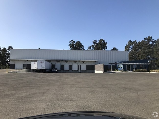
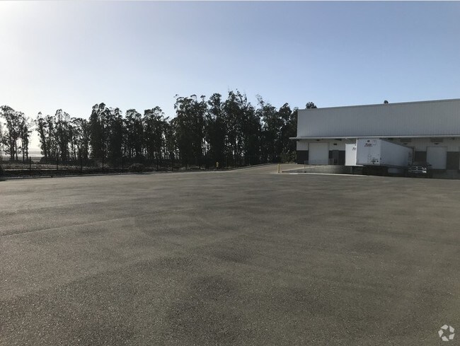
Property Record
1793 Via Entrada Way, Nipomo, CA 93444

NEARBY LISTINGS FOR SALE OR LEASE
Property Detail
1793 Via Entrada Way
San Luis Obispo-Paso Robles-Arroyo Grande, CA
Standard Eucalyptus Tr
091-509-005
TRACT 2341-1 LT 1304
Warehouse
San Luis Obispo
X
California
06079C1618G
1304
2024
0.96 AC
2025
South 101 Corridor
012306
San Luis Obispo/Paso Robles
19,550 SF
DEMOGRAPHICS near 1793 Via Entrada Way
1 Mile
3 Mile
5 Mile
2024 Total Population
1,330
7,227
32,346
2029 Population
1,324
7,120
31,870
Pop Growth 2024-2029
(0.45%)
(1.48%)
(1.47%)
Average Age
54
52
42
2024 Total Households
564
2,959
10,907
HH Growth 2024-2029
(0.53%)
(1.45%)
(1.66%)
Median Household Inc
$134,936
$125,030
$85,458
Avg Household Size
2.30
2.40
2.90
2024 Avg HH Vehicles
2.00
2.00
2.00
Median Home Value
$877,717
$843,293
$697,384
Median Year Built
2008
2001
1990
Nearby Places
Map Layers
Map Styles
 Street
 Aerial
- Restaurants
- Banks
- Shops
- Fitness
- Groceries
PUBLIC TRANSPORTATION
COMMUTER RAIL
DRIVE
WALK
Distance
8 min
4.5 mi
AIRPORT
San Luis County Regional
DRIVE
WALK
Distance
San Luis County Regional
32 min
19.0 mi
SALE & LEASE HISTORY
LISTING DATE
SALE/LEASE

Nov 25, 2019
For Lease
Nearby Properties
Address
Land Use
TOTAL SIZE
Lot Size
Zoning
Address
Land Use
TOTAL SIZE
Lot Size
Zoning
46,998 SF
564 AC
IND
Address
Land Use
TOTAL SIZE
Lot Size
Zoning
43.16 AC
RR
Address
Land Use
TOTAL SIZE
Lot Size
Zoning
124,604 SF
10.51 AC
IND
Address
Land Use
TOTAL SIZE
Lot Size
Zoning
1,200 SF
386.52 AC
AG
Address
Land Use
TOTAL SIZE
Lot Size
Zoning
71.70 AC
RR
Address
Land Use
TOTAL SIZE
Lot Size
Zoning
39.09 AC
RR
Address
Land Use
TOTAL SIZE
Lot Size
Zoning
87,964 SF
4.67 AC
IND
Address
Land Use
TOTAL SIZE
Lot Size
Zoning
47,500 SF
AG
Address
Land Use
TOTAL SIZE
Lot Size
Zoning
253.32 AC
AG
Address
Land Use
TOTAL SIZE
Lot Size
Zoning
216.60 AC
AG
Address
Land Use
TOTAL SIZE
Lot Size
Zoning
31,790 SF
2.28 AC
CS
Address
Land Use
TOTAL SIZE
Lot Size
Zoning
47,041 SF
8.98 AC
IND
Address
Land Use
TOTAL SIZE
Lot Size
Zoning
301 AC
AG
Address
Land Use
TOTAL SIZE
Lot Size
Zoning
194.65 AC
AG
Address
Land Use
TOTAL SIZE
Lot Size
Zoning
2,520 SF
39.20 AC
RR
Address
Land Use
TOTAL SIZE
Lot Size
Zoning
2,208 SF
305 AC
AG
Address
Land Use
TOTAL SIZE
Lot Size
Zoning
19.51 AC
Address
Land Use
TOTAL SIZE
Lot Size
Zoning
563.50 AC
AG
Address
Land Use
TOTAL SIZE
Lot Size
Zoning
124.60 AC
AG
Address
Land Use
TOTAL SIZE
Lot Size
Zoning
228 AC
AG
Address
Land Use
TOTAL SIZE
Lot Size
Zoning
0.01 AC
IND
Address
Land Use
TOTAL SIZE
Lot Size
Zoning
19,200 SF
1.24 AC
IND
Address
Land Use
TOTAL SIZE
Lot Size
Zoning
286 AC
AG
Address
Land Use
TOTAL SIZE
Lot Size
Zoning
122.84 AC
AG
Address
Land Use
TOTAL SIZE
Lot Size
Zoning
20.78 AC
RR
Address
Land Use
TOTAL SIZE
Lot Size
Zoning
289 AC
AG
Address
Land Use
TOTAL SIZE
Lot Size
Zoning
76,234 SF
4.67 AC
IND
Address
Land Use
TOTAL SIZE
Lot Size
Zoning
41,952 SF
2.38 AC
IND
Address
Land Use
TOTAL SIZE
Lot Size
Zoning
4,544 SF
55.75 AC
AG
Address
Land Use
TOTAL SIZE
Lot Size
Zoning
119 AC
AG
The World's #1 Commercial Real Estate Marketplace
Connect with us
© 2026 CoStar Group
The information above has been obtained from sources believed reliable. While we do not doubt its accuracy we have not verified it and make no guarantee, warranty or representation about it. It is your responsibility to independently confirm its accuracy and completeness. Any projections, opinions, assumptions, or estimates used are for example only and do not represent the current or future performance of the property. The value of this transaction to you depends on tax and other factors which should be evaluated by your tax, financial, and legal advisors. You and your advisors should conduct a careful, independent investigation of the property to determine to your satisfaction the suitability of the property for your needs.