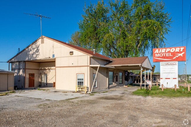
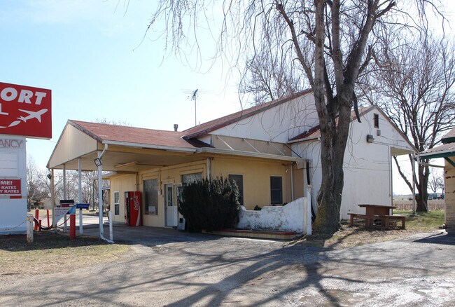
Property Record
1795 E 1500 Rd, Lawrence, KS 66044

Save to a Folder
{{folder.Name}}
{{folder.ListingIds.length}} Properties
{{folder.ListingIds.length}} Property
Create a New Folder
Property Detail
1795 E 1500 Rd
074-19-0-10-01-004.00-0
2.49AC 19-12-20 TRACT IN NE/4 DESC AS: COMM AT NE COR OF NE/4; TH S88DEG29'11"W ALONG N LN OF NE/4 483.04FT; TH S02DEG16'20"E
Vehiclerentalsvehiclesales
DOUGLAS
B2
Kansas
2025
2.46 AC
2025
Topeka/Lawrence
000100
Kansas City
4,800 SF
Lawrence, KS
NEARBY LISTINGS FOR SALE OR LEASE
-
-
View all Lawrence listings for sale on LoopNet.com
DEMOGRAPHICS near 1795 E 1500 Rd
1 mile
3 mile
5 mile
2025 Total Population
167
23,756
75,482
2030 Population
175
24,387
77,387
Pop Growth 2025-2030
+ 4.79%
+ 2.66%
+ 2.52%
Average Age
41
35
36
2025 Total Households
64
10,305
31,236
HH Growth 2025-2030
+ 4.69%
+ 2.95%
+ 2.79%
Median Household Inc
$65,833
$58,735
$60,371
Avg Household Size
2.30
2.10
2.10
2025 Avg HH Vehicles
2.00
2.00
2.00
Median Home Value
$303,571
$267,714
$272,232
Median Year Built
1996
1975
1980
Nearby Places
Map Layers
Map Styles
 Street
 Aerial
Layers
 Traffic
 Biking
Places
Listings with unknown addresses are not visible on the map
- Restaurants
- Banks
- Shops
- Fitness
- Groceries
PUBLIC TRANSPORTATION
COMMUTER RAIL
Drive
Walk
Distance
6 min
2.8 mi
AIRPORT
Kansas City International
Drive
Walk
Distance
Kansas City International
57 min
49.4 mi
Nearby Properties
Address
Land Use
TOTAL SIZE
Lot Size
Zoning
Address
Land Use
TOTAL SIZE
Lot Size
Zoning
63,837 SF
20.79 AC
H
Address
Land Use
TOTAL SIZE
Lot Size
Zoning
335,349 SF
3.17 AC
RD
Address
Land Use
TOTAL SIZE
Lot Size
Zoning
112,500 SF
3.90 AC
RM1
Address
Land Use
TOTAL SIZE
Lot Size
Zoning
47,457 SF
2.58 AC
Address
Land Use
TOTAL SIZE
Lot Size
Zoning
162,086 SF
3 AC
RD
Address
Land Use
TOTAL SIZE
Lot Size
Zoning
67,500 SF
4.03 AC
RM1
Address
Land Use
TOTAL SIZE
Lot Size
Zoning
5,984 SF
142.30 AC
M2
Address
Land Use
TOTAL SIZE
Lot Size
Zoning
337,280 SF
0.60 AC
RD
Address
Land Use
TOTAL SIZE
Lot Size
Zoning
31,750 SF
0.73 AC
Address
Land Use
TOTAL SIZE
Lot Size
Zoning
34,479 SF
1.08 AC
C4
Address
Land Use
TOTAL SIZE
Lot Size
Zoning
131,625 SF
2.32 AC
C3
Address
Land Use
TOTAL SIZE
Lot Size
Zoning
2,728 SF
305 AC
RS1
Address
Land Use
TOTAL SIZE
Lot Size
Zoning
24,600 SF
8.90 AC
M3
Address
Land Use
TOTAL SIZE
Lot Size
Zoning
53,064 SF
5.79 AC
M2
Address
Land Use
TOTAL SIZE
Lot Size
Zoning
53,678 SF
9.40 AC
RS2
Address
Land Use
TOTAL SIZE
Lot Size
Zoning
47,152 SF
4.16 AC
RS2
Address
Land Use
TOTAL SIZE
Lot Size
Zoning
5,506 SF
6.10 AC
Address
Land Use
TOTAL SIZE
Lot Size
Zoning
35,209 SF
4.56 AC
O1
Address
Land Use
TOTAL SIZE
Lot Size
Zoning
21,856 SF
0.86 AC
RO1
Address
Land Use
TOTAL SIZE
Lot Size
Zoning
467,472 SF
5.06 AC
RD
Address
Land Use
TOTAL SIZE
Lot Size
Zoning
38,914 SF
0.67 AC
C3
Address
Land Use
TOTAL SIZE
Lot Size
Zoning
48,077 SF
8.70 AC
RS2
Address
Land Use
TOTAL SIZE
Lot Size
Zoning
32,964 SF
3.31 AC
RS2
Address
Land Use
TOTAL SIZE
Lot Size
Zoning
25,503 SF
4.50 AC
C4
Address
Land Use
TOTAL SIZE
Lot Size
Zoning
16,013 SF
Address
Land Use
TOTAL SIZE
Lot Size
Zoning
25,779 SF
1.15 AC
RM3
Address
Land Use
TOTAL SIZE
Lot Size
Zoning
29,554 SF
1.07 AC
RO1
Address
Land Use
TOTAL SIZE
Lot Size
Zoning
62,756 SF
7.20 AC
M2
Address
Land Use
TOTAL SIZE
Lot Size
Zoning
944,874 SF
49.40 AC
M2
Address
Land Use
TOTAL SIZE
Lot Size
Zoning
20,256 SF
0.54 AC
C3
The World's #1 Commercial Real Estate Marketplace
Connect with us
© 2026 CoStar Group
The information above has been obtained from sources believed reliable. While we do not doubt its accuracy we have not verified it and make no guarantee, warranty or representation about it. It is your responsibility to independently confirm its accuracy and completeness. Any projections, opinions, assumptions, or estimates used are for example only and do not represent the current or future performance of the property. The value of this transaction to you depends on tax and other factors which should be evaluated by your tax, financial, and legal advisors. You and your advisors should conduct a careful, independent investigation of the property to determine to your satisfaction the suitability of the property for your needs.