Property Record
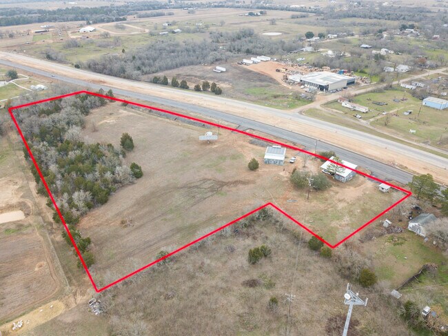
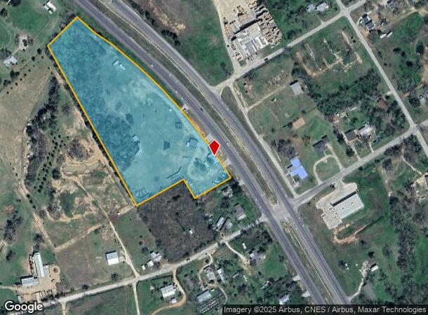
1799 E Us Highway 290 E, Mcdade, TX 78650
Property Detail
1799 E Us Highway 290 E
10087
Mcdade City
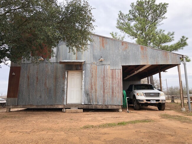
Sfr
MCDADE CITY, DIV 13 AND BLK 16D, ACRES 8.180
X
Bastrop
48287C0225C
Texas
2024
8.18 AC
2025
Bastrop County
950102
Austin
1,340 SF
Austin-Round Rock-San Marcos, TX
NEARBY LISTINGS FOR SALE OR LEASE
-
-
View all Mcdade listings for sale on LoopNet.com
DEMOGRAPHICS near 1799 E Us Highway 290 E
1 mile
3 mile
5 mile
2024 Total Population
636
1,152
2,902
2029 Population
759
1,373
3,522
Pop Growth 2024-2029
+ 19.34%
+ 19.18%
+ 21.36%
Average Age
40
40
39
2024 Total Households
225
409
1,004
HH Growth 2024-2029
+ 20.44%
+ 20.05%
+ 22.31%
Median Household Inc
$70,499
$70,945
$96,649
Avg Household Size
2.80
2.80
2.80
2024 Avg HH Vehicles
2.00
2.00
2.00
Median Home Value
$219,444
$218,939
$259,999
Median Year Built
1985
1985
1992
Nearby Places
Map Layers
Map Styles
 Street
 Aerial
Transit
 Traffic
 Biking
Places
Listings with unknown addresses are not visible on the map
- Restaurants
- Banks
- Shops
- Fitness
- Groceries
PUBLIC TRANSPORTATION
AIRPORT
Austin-Bergstrom International
Drive
Walk
Distance
Austin-Bergstrom International
51 min
38.1 mi
Freight Ports
Calhoun Port
Drive
Walk
Distance
Calhoun Port
180 min
153.2 mi
SALE & LEASE HISTORY
LISTING DATE
SALE/LEASE

Feb 09, 2021
For Sale
Nearby Properties
Address
Land Use
TOTAL SIZE
Lot Size
Zoning
Address
Land Use
TOTAL SIZE
Lot Size
Zoning
38,909 SF
61.97 AC
Address
Land Use
TOTAL SIZE
Lot Size
Zoning
18,693 SF
1.43 AC
Address
Land Use
TOTAL SIZE
Lot Size
Zoning
11,322 SF
1.04 AC
Address
Land Use
TOTAL SIZE
Lot Size
Zoning
7,625 SF
17.23 AC
Address
Land Use
TOTAL SIZE
Lot Size
Zoning
6,826 SF
4.85 AC
Address
Land Use
TOTAL SIZE
Lot Size
Zoning
5,369 SF
2.19 AC
Address
Land Use
TOTAL SIZE
Lot Size
Zoning
5,233 SF
2.77 AC
Address
Land Use
TOTAL SIZE
Lot Size
Zoning
18,800 SF
7.17 AC
Address
Land Use
TOTAL SIZE
Lot Size
Zoning
9,165 SF
4.11 AC
Address
Land Use
TOTAL SIZE
Lot Size
Zoning
2,840 SF
5.18 AC
Address
Land Use
TOTAL SIZE
Lot Size
Zoning
7,439 SF
3 AC
Address
Land Use
TOTAL SIZE
Lot Size
Zoning
3,842 SF
10.66 AC
Address
Land Use
TOTAL SIZE
Lot Size
Zoning
4,522 SF
2.99 AC
Address
Land Use
TOTAL SIZE
Lot Size
Zoning
4,495 SF
3.77 AC
Address
Land Use
TOTAL SIZE
Lot Size
Zoning
5,590 SF
4 AC
Address
Land Use
TOTAL SIZE
Lot Size
Zoning
Address
Land Use
TOTAL SIZE
Lot Size
Zoning
7,000 SF
0.66 AC
Address
Land Use
TOTAL SIZE
Lot Size
Zoning
20,080 SF
27.87 AC
Address
Land Use
TOTAL SIZE
Lot Size
Zoning
4,296 SF
4.09 AC
Address
Land Use
TOTAL SIZE
Lot Size
Zoning
3,306 SF
5.16 AC
Address
Land Use
TOTAL SIZE
Lot Size
Zoning
3,756 SF
84.30 AC
Address
Land Use
TOTAL SIZE
Lot Size
Zoning
6,728 SF
5.93 AC
Address
Land Use
TOTAL SIZE
Lot Size
Zoning
3,542 SF
6.86 AC
Address
Land Use
TOTAL SIZE
Lot Size
Zoning
6,645 SF
104.26 AC
Address
Land Use
TOTAL SIZE
Lot Size
Zoning
2,318 SF
10 AC
Address
Land Use
TOTAL SIZE
Lot Size
Zoning
2,702 SF
10.75 AC
Address
Land Use
TOTAL SIZE
Lot Size
Zoning
3,005 SF
5.02 AC
Address
Land Use
TOTAL SIZE
Lot Size
Zoning
2,269 SF
13.28 AC
Address
Land Use
TOTAL SIZE
Lot Size
Zoning
4,347 SF
8.76 AC
The World's #1 Commercial Real Estate Marketplace
Connect with us
© 2026 CoStar Group
The information above has been obtained from sources believed reliable. While we do not doubt its accuracy we have not verified it and make no guarantee, warranty or representation about it. It is your responsibility to independently confirm its accuracy and completeness. Any projections, opinions, assumptions, or estimates used are for example only and do not represent the current or future performance of the property. The value of this transaction to you depends on tax and other factors which should be evaluated by your tax, financial, and legal advisors. You and your advisors should conduct a careful, independent investigation of the property to determine to your satisfaction the suitability of the property for your needs.