Property Record
17K Int St, Montgomery, NY 12549
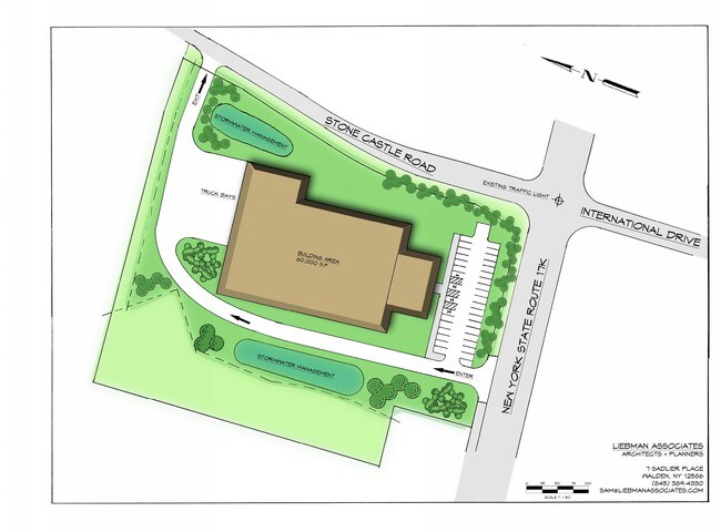


This Property Is For Sale
Property Detail
17K Int St
Kiryas Joel-Poughkeepsie-Newburgh, NY
ORANGE
334289-026-000-0001-062.100-0000
New York
Industrialacreage
62.10
B and X Area of moderate flood hazard, usually the area between the limits of the 100-year and 500-year floods.
6 AC
2024
Newburgh
2025
Northern New Jersey
010802
NEARBY LISTINGS FOR SALE OR LEASE
DEMOGRAPHICS near 17K Int St
1 mile
3 mile
5 mile
2025 Total Population
2,138
13,395
44,548
2030 Population
2,210
13,765
45,517
Pop Growth 2025-2030
+ 3.37%
+ 2.76%
+ 2.18%
Average Age
41
42
41
2025 Total Households
779
4,913
16,192
HH Growth 2025-2030
+ 3.34%
+ 2.89%
+ 2.25%
Median Household Inc
$95,049
$100,681
$97,245
Avg Household Size
2.60
2.60
2.70
2025 Avg HH Vehicles
2.00
2.00
2.00
Median Home Value
$335,778
$359,286
$355,090
Median Year Built
1960
1982
1977
Nearby Places
Map Layers
Map Styles
 Street
 Aerial
Layers
 Traffic
 Biking
Places
Listings with unknown addresses are not visible on the map
- Restaurants
- Banks
- Shops
- Fitness
- Groceries
PUBLIC TRANSPORTATION
COMMUTER RAIL
Salisbury Mills Cornwall (Bergen County/Port Jervis Line - NJ Transit Commuter Rail (NJ Transit), Main/Port Jervis Line - NJ Transit Commuter Rail (NJ Transit))
Drive
Walk
Distance
Salisbury Mills Cornwall (Bergen County/Port Jervis Line - NJ Transit Commuter Rail (NJ Transit), Main/Port Jervis Line - NJ Transit Commuter Rail (NJ Transit))
17 min
8.8 mi
AIRPORT
New York Stewart International
Drive
Walk
Distance
New York Stewart International
8 min
4.2 mi
Freight Ports
Port Newark Container Terminal
Drive
Walk
Distance
Port Newark Container Terminal
92 min
70.3 mi
Nearby Properties
Address
Land Use
TOTAL SIZE
Lot Size
Zoning
Address
Land Use
TOTAL SIZE
Lot Size
Zoning
1,013,616 SF
186.68 AC
I1
Address
Land Use
TOTAL SIZE
Lot Size
Zoning
1,015,632 SF
187.79 AC
I1
Address
Land Use
TOTAL SIZE
Lot Size
Zoning
130,037 SF
136 AC
Address
Land Use
TOTAL SIZE
Lot Size
Zoning
50.30 AC
Address
Land Use
TOTAL SIZE
Lot Size
Zoning
8.50 AC
AP
Address
Land Use
TOTAL SIZE
Lot Size
Zoning
44.50 AC
Address
Land Use
TOTAL SIZE
Lot Size
Zoning
505,577 SF
50.50 AC
Address
Land Use
TOTAL SIZE
Lot Size
Zoning
71,379 SF
20.80 AC
Address
Land Use
TOTAL SIZE
Lot Size
Zoning
20.90 AC
Address
Land Use
TOTAL SIZE
Lot Size
Zoning
10.30 AC
Address
Land Use
TOTAL SIZE
Lot Size
Zoning
653 AC
AP
Address
Land Use
TOTAL SIZE
Lot Size
Zoning
132,000 SF
14.90 AC
Address
Land Use
TOTAL SIZE
Lot Size
Zoning
101,595 SF
70.20 AC
RA-.5
Address
Land Use
TOTAL SIZE
Lot Size
Zoning
Address
Land Use
TOTAL SIZE
Lot Size
Zoning
8.40 AC
AP
Address
Land Use
TOTAL SIZE
Lot Size
Zoning
Address
Land Use
TOTAL SIZE
Lot Size
Zoning
110,484 SF
62.90 AC
RA2
Address
Land Use
TOTAL SIZE
Lot Size
Zoning
Address
Land Use
TOTAL SIZE
Lot Size
Zoning
3.20 AC
Address
Land Use
TOTAL SIZE
Lot Size
Zoning
76,227 SF
5.80 AC
I3
Address
Land Use
TOTAL SIZE
Lot Size
Zoning
64,191 SF
10 AC
06
Address
Land Use
TOTAL SIZE
Lot Size
Zoning
12.30 AC
Address
Land Use
TOTAL SIZE
Lot Size
Zoning
Address
Land Use
TOTAL SIZE
Lot Size
Zoning
149,051 SF
14.10 AC
I1
Address
Land Use
TOTAL SIZE
Lot Size
Zoning
81,563 SF
5.70 AC
B4
Address
Land Use
TOTAL SIZE
Lot Size
Zoning
74,046 SF
53.80 AC
RA2
Address
Land Use
TOTAL SIZE
Lot Size
Zoning
60.60 AC
06
Address
Land Use
TOTAL SIZE
Lot Size
Zoning
40,200 SF
14.40 AC
Address
Land Use
TOTAL SIZE
Lot Size
Zoning
72,000 SF
14.90 AC
Address
Land Use
TOTAL SIZE
Lot Size
Zoning
The World's #1 Commercial Real Estate Marketplace
Connect with us
© 2026 CoStar Group
The information above has been obtained from sources believed reliable. While we do not doubt its accuracy we have not verified it and make no guarantee, warranty or representation about it. It is your responsibility to independently confirm its accuracy and completeness. Any projections, opinions, assumptions, or estimates used are for example only and do not represent the current or future performance of the property. The value of this transaction to you depends on tax and other factors which should be evaluated by your tax, financial, and legal advisors. You and your advisors should conduct a careful, independent investigation of the property to determine to your satisfaction the suitability of the property for your needs.