Property Record
6732 Sw 17Th St, Topeka, KS 66615
NEARBY LISTINGS FOR SALE OR LEASE
Property Detail
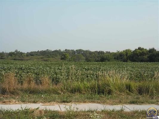
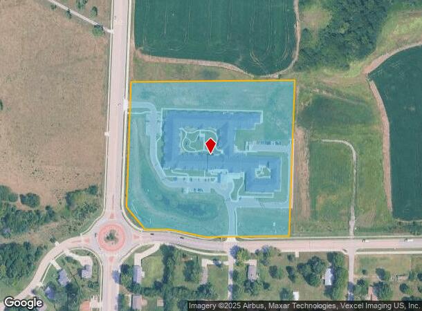
6732 Sw 17Th St
Topeka, KS
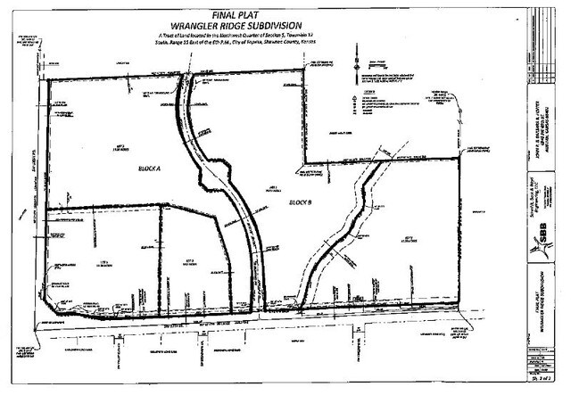
Wrangler Ridge Sub
143-05-0-20-02-001-000
WRANGLER RIDGE SUB, S05, T12, R15, BLOCK A, LOT 1, ACRES 11.05, BLK A LOT 1 WRANGLER RIDGE SUB
Commercialnec
Shawnee
X
Kansas
20177C0192E
1
2024
11.05 AC
2025
Topeka
003607
Kansas City
DEMOGRAPHICS near 6732 Sw 17Th St
1 Mile
3 Mile
5 Mile
2024 Total Population
2,403
37,339
81,837
2029 Population
2,350
36,612
80,754
Pop Growth 2024-2029
(2.21%)
(1.95%)
(1.32%)
Average Age
44
43
41
2024 Total Households
1,052
16,718
35,987
HH Growth 2024-2029
(2.38%)
(2.05%)
(1.42%)
Median Household Inc
$84,230
$64,759
$57,768
Avg Household Size
2.20
2.20
2.20
2024 Avg HH Vehicles
2.00
2.00
2.00
Median Home Value
$216,060
$170,504
$153,213
Median Year Built
1996
1980
1971
Nearby Places
Map Layers
Map Styles
 Street
 Aerial
- Restaurants
- Banks
- Shops
- Fitness
- Groceries
PUBLIC TRANSPORTATION
COMMUTER RAIL
Topeka Amtrak Station (Southwest Chief - Amtrak)
DRIVE
WALK
Distance
Topeka Amtrak Station (Southwest Chief - Amtrak)
12 min
8.1 mi
Freight Ports
Tulsa Port Of Catoosa
DRIVE
WALK
Distance
Tulsa Port Of Catoosa
276 min
227.0 mi
SALE & LEASE HISTORY
LISTING DATE
SALE/LEASE

Apr 29, 2019
For Sale
Nearby Properties
Address
Land Use
TOTAL SIZE
Lot Size
Zoning
Address
Land Use
TOTAL SIZE
Lot Size
Zoning
43,282 SF
19.33 AC
PUD,M2
Address
Land Use
TOTAL SIZE
Lot Size
Zoning
32,544 SF
17.25 AC
PUD
Address
Land Use
TOTAL SIZE
Lot Size
Zoning
218,962 SF
49.63 AC
R1
Address
Land Use
TOTAL SIZE
Lot Size
Zoning
94,830 SF
17.09 AC
PUD,M4
Address
Land Use
TOTAL SIZE
Lot Size
Zoning
208,685 SF
38.23 AC
R1
Address
Land Use
TOTAL SIZE
Lot Size
Zoning
70,578 SF
10.16 AC
PUD,C2
Address
Land Use
TOTAL SIZE
Lot Size
Zoning
52,375 SF
12.94 AC
RR1
Address
Land Use
TOTAL SIZE
Lot Size
Zoning
88,935 SF
20.24 AC
C4
Address
Land Use
TOTAL SIZE
Lot Size
Zoning
175,246 SF
80.42 AC
R1
Address
Land Use
TOTAL SIZE
Lot Size
Zoning
6.95 AC
PUD,OI1
Address
Land Use
TOTAL SIZE
Lot Size
Zoning
81,364 SF
19.52 AC
R1
Address
Land Use
TOTAL SIZE
Lot Size
Zoning
53,136 SF
18.28 AC
PUD,M2
Address
Land Use
TOTAL SIZE
Lot Size
Zoning
38,087 SF
10.27 AC
PUD,M4
Address
Land Use
TOTAL SIZE
Lot Size
Zoning
15,880 SF
85.20 AC
R1
Address
Land Use
TOTAL SIZE
Lot Size
Zoning
7,704 SF
13.43 AC
PUD
Address
Land Use
TOTAL SIZE
Lot Size
Zoning
22,194 SF
3.59 AC
M4
Address
Land Use
TOTAL SIZE
Lot Size
Zoning
19,892 SF
3.51 AC
M4
Address
Land Use
TOTAL SIZE
Lot Size
Zoning
31,132 SF
111.36 AC
R1
Address
Land Use
TOTAL SIZE
Lot Size
Zoning
19.37 AC
Address
Land Use
TOTAL SIZE
Lot Size
Zoning
33,487 SF
2.65 AC
R1
Address
Land Use
TOTAL SIZE
Lot Size
Zoning
231,116 SF
42.17 AC
PUD,OI3,RR
Address
Land Use
TOTAL SIZE
Lot Size
Zoning
59,337 SF
6.84 AC
R1
Address
Land Use
TOTAL SIZE
Lot Size
Zoning
72,482 SF
19.53 AC
R1
Address
Land Use
TOTAL SIZE
Lot Size
Zoning
51,636 SF
3.89 AC
C4
Address
Land Use
TOTAL SIZE
Lot Size
Zoning
72,105 SF
13.79 AC
C2,M1,M2,R
Address
Land Use
TOTAL SIZE
Lot Size
Zoning
57,380 SF
15.03 AC
RR1
Address
Land Use
TOTAL SIZE
Lot Size
Zoning
50,795 SF
7.70 AC
R1
Address
Land Use
TOTAL SIZE
Lot Size
Zoning
36,511 SF
7.05 AC
R1
Address
Land Use
TOTAL SIZE
Lot Size
Zoning
61,383 SF
8.09 AC
R1
The World's #1 Commercial Real Estate Marketplace
Connect with us
© 2026 CoStar Group
The information above has been obtained from sources believed reliable. While we do not doubt its accuracy we have not verified it and make no guarantee, warranty or representation about it. It is your responsibility to independently confirm its accuracy and completeness. Any projections, opinions, assumptions, or estimates used are for example only and do not represent the current or future performance of the property. The value of this transaction to you depends on tax and other factors which should be evaluated by your tax, financial, and legal advisors. You and your advisors should conduct a careful, independent investigation of the property to determine to your satisfaction the suitability of the property for your needs.