Property Record
18 Bowman Dr, Waynesville, NC 28785


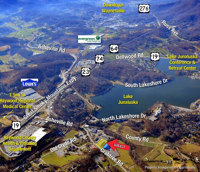
NEARBY LISTINGS FOR SALE OR LEASE
Property Detail
18 Bowman Dr
8627-10-8959
Toothland
Medicalbuilding
18 BOWMAN DR #5B
X
Haywood
3700862700J
North Carolina
0
0.99 AC
2025
Haywood County
920602
Asheville
9,000 SF
Asheville, NC
DEMOGRAPHICS near 18 Bowman Dr
1 Mile
3 Mile
5 Mile
2024 Total Population
1,880
12,183
28,325
2029 Population
1,941
12,398
29,087
Pop Growth 2024-2029
+ 3.24%
+ 1.76%
+ 2.69%
Average Age
49
45
46
2024 Total Households
840
5,336
12,597
HH Growth 2024-2029
+ 3.21%
+ 1.69%
+ 2.68%
Median Household Inc
$69,290
$57,829
$53,666
Avg Household Size
2.20
2.20
2.20
2024 Avg HH Vehicles
2.00
2.00
2.00
Median Home Value
$279,317
$235,131
$240,143
Median Year Built
1970
1980
1981
Nearby Places
Map Layers
Map Styles
 Street
 Aerial
- Restaurants
- Banks
- Shops
- Fitness
- Groceries
PUBLIC TRANSPORTATION
AIRPORT
Asheville Regional
DRIVE
WALK
Distance
Asheville Regional
42 min
31.8 mi
SALE & LEASE HISTORY
LISTING DATE
SALE/LEASE

Sep 24, 2016
For Sale
Sep 23, 2020
For Sale
Sep 07, 2023
For Lease
Oct 13, 2020
For Lease
Jul 31, 2024
For Lease
Jul 14, 2022
For Lease
Nearby Properties
Address
Land Use
TOTAL SIZE
Lot Size
Zoning
Address
Land Use
TOTAL SIZE
Lot Size
Zoning
52,051 SF
55.78 AC
Address
Land Use
TOTAL SIZE
Lot Size
Zoning
3,330 SF
3.73 AC
Address
Land Use
TOTAL SIZE
Lot Size
Zoning
1,500 SF
294.65 AC
Address
Land Use
TOTAL SIZE
Lot Size
Zoning
23,615 SF
7.17 AC
Address
Land Use
TOTAL SIZE
Lot Size
Zoning
5,800 SF
54.05 AC
COI
Address
Land Use
TOTAL SIZE
Lot Size
Zoning
17,244 SF
40.20 AC
Address
Land Use
TOTAL SIZE
Lot Size
Zoning
37,508 SF
3.44 AC
DJAC
Address
Land Use
TOTAL SIZE
Lot Size
Zoning
87,969 SF
19.78 AC
RATC
Address
Land Use
TOTAL SIZE
Lot Size
Zoning
12,520 SF
3.26 AC
COI
Address
Land Use
TOTAL SIZE
Lot Size
Zoning
19,943 SF
13.52 AC
Address
Land Use
TOTAL SIZE
Lot Size
Zoning
94,031 SF
16.74 AC
RATC
Address
Land Use
TOTAL SIZE
Lot Size
Zoning
35,901 SF
12.80 AC
Address
Land Use
TOTAL SIZE
Lot Size
Zoning
16,836 SF
0.57 AC
Address
Land Use
TOTAL SIZE
Lot Size
Zoning
25,344 SF
1.16 AC
CBD
Address
Land Use
TOTAL SIZE
Lot Size
Zoning
115,911 SF
16.92 AC
Address
Land Use
TOTAL SIZE
Lot Size
Zoning
49,732 SF
6.63 AC
Address
Land Use
TOTAL SIZE
Lot Size
Zoning
13,608 SF
22.01 AC
RCND
Address
Land Use
TOTAL SIZE
Lot Size
Zoning
52,904 SF
23.08 AC
HMND
Address
Land Use
TOTAL SIZE
Lot Size
Zoning
277,784 SF
35.12 AC
HTD
Address
Land Use
TOTAL SIZE
Lot Size
Zoning
14,806 SF
9.76 AC
Address
Land Use
TOTAL SIZE
Lot Size
Zoning
30,460 SF
13.04 AC
Address
Land Use
TOTAL SIZE
Lot Size
Zoning
124,013 SF
11.81 AC
RATC
Address
Land Use
TOTAL SIZE
Lot Size
Zoning
5,152 SF
2.01 AC
Address
Land Use
TOTAL SIZE
Lot Size
Zoning
28,922 SF
28.92 AC
Address
Land Use
TOTAL SIZE
Lot Size
Zoning
4,031 SF
96.51 AC
Address
Land Use
TOTAL SIZE
Lot Size
Zoning
119,364 SF
8.05 AC
RATC
Address
Land Use
TOTAL SIZE
Lot Size
Zoning
48,438 SF
5.25 AC
Address
Land Use
TOTAL SIZE
Lot Size
Zoning
1,800 SF
4.21 AC
Address
Land Use
TOTAL SIZE
Lot Size
Zoning
7,592 SF
3.66 AC
CC2
Address
Land Use
TOTAL SIZE
Lot Size
Zoning
4,006 SF
2.92 AC
The World's #1 Commercial Real Estate Marketplace
Connect with us
© 2025 CoStar Group
The information above has been obtained from sources believed reliable. While we do not doubt its accuracy we have not verified it and make no guarantee, warranty or representation about it. It is your responsibility to independently confirm its accuracy and completeness. Any projections, opinions, assumptions, or estimates used are for example only and do not represent the current or future performance of the property. The value of this transaction to you depends on tax and other factors which should be evaluated by your tax, financial, and legal advisors. You and your advisors should conduct a careful, independent investigation of the property to determine to your satisfaction the suitability of the property for your needs.