Property Record
18 Elm St, Hatfield, MA 01038
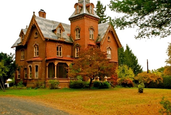


This Property Is For Sale
NEARBY LISTINGS FOR SALE OR LEASE
Property Detail
18 Elm St
Hartford
Hampshire
Springfield, MA
Massachusetts
HATF-000223-000144
4.25 AC
Sfr
Hampshire County
5,912 SF
DEMOGRAPHICS near 18 Elm St
1 Mile
3 Mile
5 Mile
2024 Total Population
1,197
9,192
58,530
2029 Population
901
7,106
49,572
Pop Growth 2024-2029
(24.73%)
(22.69%)
(15.30%)
Average Age
49
45
36
2024 Total Households
572
4,167
18,590
HH Growth 2024-2029
(23.78%)
(22.82%)
(21.48%)
Median Household Inc
$79,945
$89,794
$72,925
Avg Household Size
2.10
2.20
2.10
2024 Avg HH Vehicles
2.00
2.00
2.00
Median Home Value
$392,212
$384,170
$387,461
Median Year Built
1959
1961
1960
Nearby Places
Map Layers
Map Styles
 Street
 Aerial
- Restaurants
- Banks
- Shops
- Fitness
- Groceries
PUBLIC TRANSPORTATION
COMMUTER RAIL
DRIVE
WALK
Distance
12 min
5.4 mi
AIRPORT
Bradley International
DRIVE
WALK
Distance
Bradley International
57 min
35.1 mi
Nearby Properties
Address
Land Use
TOTAL SIZE
Lot Size
Zoning
Address
Land Use
TOTAL SIZE
Lot Size
Zoning
185,998 SF
32.09 AC
I
Address
Land Use
TOTAL SIZE
Lot Size
Zoning
476,724 SF
57.56 AC
I
Address
Land Use
TOTAL SIZE
Lot Size
Zoning
9,424 SF
17.24 AC
AR
Address
Land Use
TOTAL SIZE
Lot Size
Zoning
18.04 AC
URB
Address
Land Use
TOTAL SIZE
Lot Size
Zoning
84,480 SF
6.15 AC
I
Address
Land Use
TOTAL SIZE
Lot Size
Zoning
61,650 SF
12.37 AC
B
Address
Land Use
TOTAL SIZE
Lot Size
Zoning
12.23 AC
HB
Address
Land Use
TOTAL SIZE
Lot Size
Zoning
7.58 AC
HB
Address
Land Use
TOTAL SIZE
Lot Size
Zoning
10.37 AC
HB
Address
Land Use
TOTAL SIZE
Lot Size
Zoning
21.77 AC
GI
Address
Land Use
TOTAL SIZE
Lot Size
Zoning
139,648 SF
13.09 AC
B
Address
Land Use
TOTAL SIZE
Lot Size
Zoning
359,938 SF
38.84 AC
I
Address
Land Use
TOTAL SIZE
Lot Size
Zoning
115,090 SF
14.09 AC
B
Address
Land Use
TOTAL SIZE
Lot Size
Zoning
59,471 SF
35 AC
LGT
Address
Land Use
TOTAL SIZE
Lot Size
Zoning
4.19 AC
HB
Address
Land Use
TOTAL SIZE
Lot Size
Zoning
15,130 SF
2.60 AC
B
Address
Land Use
TOTAL SIZE
Lot Size
Zoning
5.36 AC
HB
Address
Land Use
TOTAL SIZE
Lot Size
Zoning
5.06 AC
URC
Address
Land Use
TOTAL SIZE
Lot Size
Zoning
53,344 SF
9.07 AC
TC
Address
Land Use
TOTAL SIZE
Lot Size
Zoning
280,518 SF
60.66 AC
I
Address
Land Use
TOTAL SIZE
Lot Size
Zoning
10.07 AC
URB
Address
Land Use
TOTAL SIZE
Lot Size
Zoning
81,537 SF
2.41 AC
B
Address
Land Use
TOTAL SIZE
Lot Size
Zoning
64,239 SF
10 AC
AR
Address
Land Use
TOTAL SIZE
Lot Size
Zoning
55,644 SF
5.21 AC
BUS
Address
Land Use
TOTAL SIZE
Lot Size
Zoning
6,930 SF
2.95 AC
HB
Address
Land Use
TOTAL SIZE
Lot Size
Zoning
23,619 SF
2 AC
HB
Address
Land Use
TOTAL SIZE
Lot Size
Zoning
768 SF
2.13 AC
URB
Address
Land Use
TOTAL SIZE
Lot Size
Zoning
38,194 SF
3.42 AC
HB
Address
Land Use
TOTAL SIZE
Lot Size
Zoning
938 AC
RR
Address
Land Use
TOTAL SIZE
Lot Size
Zoning
32,449 SF
10.45 AC
B
The World's #1 Commercial Real Estate Marketplace
Connect with us
© 2025 CoStar Group
The information above has been obtained from sources believed reliable. While we do not doubt its accuracy we have not verified it and make no guarantee, warranty or representation about it. It is your responsibility to independently confirm its accuracy and completeness. Any projections, opinions, assumptions, or estimates used are for example only and do not represent the current or future performance of the property. The value of this transaction to you depends on tax and other factors which should be evaluated by your tax, financial, and legal advisors. You and your advisors should conduct a careful, independent investigation of the property to determine to your satisfaction the suitability of the property for your needs.