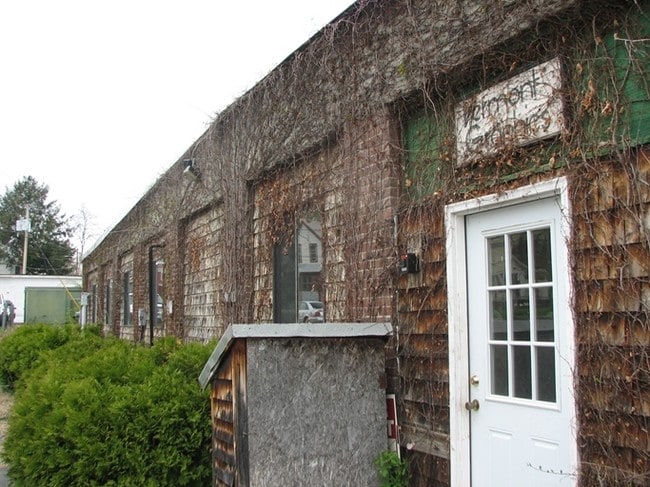
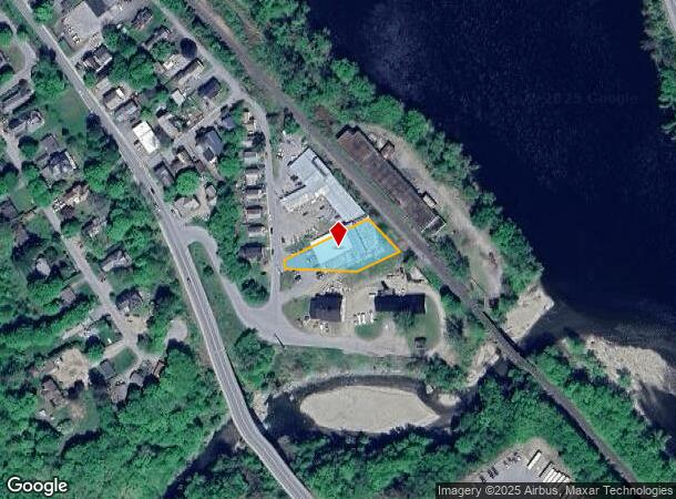
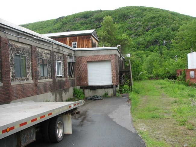
Property Record
18 Granger St, Bellows Falls, VT 05101
NEARBY LISTINGS FOR SALE OR LEASE
Property Detail
18 Granger St
Industrialgeneral
BUILDING AND LOT
X
Windham
50025C0114E
Vermont
2022
0.51 AC
2024
Other Market Areas
967000
528-166-10899
DEMOGRAPHICS near 18 Granger St
1 Mile
3 Mile
5 Mile
2024 Total Population
2,726
6,151
9,532
2029 Population
2,723
6,215
9,639
Pop Growth 2024-2029
(0.11%)
+ 1.04%
+ 1.12%
Average Age
43
44
45
2024 Total Households
1,267
2,775
4,246
HH Growth 2024-2029
(0.16%)
+ 0.86%
+ 0.85%
Median Household Inc
$52,419
$63,994
$66,601
Avg Household Size
2.10
2.20
2.20
2024 Avg HH Vehicles
1.00
2.00
2.00
Median Home Value
$160,423
$189,818
$215,164
Median Year Built
1947
1952
1961
Nearby Places
Map Layers
Map Styles
 Street
 Aerial
- Restaurants
- Banks
- Shops
- Fitness
- Groceries
PUBLIC TRANSPORTATION
COMMUTER RAIL
Bellows Falls Amtrak Station (Vermonter - Amtrak)
DRIVE
WALK
Distance
Bellows Falls Amtrak Station (Vermonter - Amtrak)
2 min
18 min
0.9 mi
Freight Ports
Albany, NY Port
DRIVE
WALK
Distance
Albany, NY Port
157 min
103.1 mi
Nearby Properties
Address
Land Use
TOTAL SIZE
Lot Size
Zoning
Address
Land Use
TOTAL SIZE
Lot Size
Zoning
13.51 AC
Address
Land Use
TOTAL SIZE
Lot Size
Zoning
Address
Land Use
TOTAL SIZE
Lot Size
Zoning
Address
Land Use
TOTAL SIZE
Lot Size
Zoning
Address
Land Use
TOTAL SIZE
Lot Size
Zoning
8.30 AC
Address
Land Use
TOTAL SIZE
Lot Size
Zoning
Address
Land Use
TOTAL SIZE
Lot Size
Zoning
Address
Land Use
TOTAL SIZE
Lot Size
Zoning
16.54 AC
RB R
Address
Land Use
TOTAL SIZE
Lot Size
Zoning
50.80 AC
Address
Land Use
TOTAL SIZE
Lot Size
Zoning
12.40 AC
Address
Land Use
TOTAL SIZE
Lot Size
Zoning
55,042 SF
12.15 AC
COM C
Address
Land Use
TOTAL SIZE
Lot Size
Zoning
Address
Land Use
TOTAL SIZE
Lot Size
Zoning
7,056 SF
80.76 AC
Address
Land Use
TOTAL SIZE
Lot Size
Zoning
28,905 SF
5.85 AC
Address
Land Use
TOTAL SIZE
Lot Size
Zoning
60,615 SF
0.91 AC
Address
Land Use
TOTAL SIZE
Lot Size
Zoning
176 AC
IND I
Address
Land Use
TOTAL SIZE
Lot Size
Zoning
19,452 SF
4.92 AC
COM C
Address
Land Use
TOTAL SIZE
Lot Size
Zoning
31,161 SF
2.36 AC
NRB11N
Address
Land Use
TOTAL SIZE
Lot Size
Zoning
31,343 SF
3.34 AC
COM C
Address
Land Use
TOTAL SIZE
Lot Size
Zoning
62,674 SF
5.65 AC
NRB11N
Address
Land Use
TOTAL SIZE
Lot Size
Zoning
Address
Land Use
TOTAL SIZE
Lot Size
Zoning
8.80 AC
Address
Land Use
TOTAL SIZE
Lot Size
Zoning
15,187 SF
10 AC
NRB11N
Address
Land Use
TOTAL SIZE
Lot Size
Zoning
Address
Land Use
TOTAL SIZE
Lot Size
Zoning
20,063 SF
4.39 AC
RUR R
Address
Land Use
TOTAL SIZE
Lot Size
Zoning
25,902 SF
7.15 AC
IND I
Address
Land Use
TOTAL SIZE
Lot Size
Zoning
5.94 AC
COM C
Address
Land Use
TOTAL SIZE
Lot Size
Zoning
12,565 SF
4.76 AC
COM C
Address
Land Use
TOTAL SIZE
Lot Size
Zoning
15,852 SF
4.10 AC
COM C
Address
Land Use
TOTAL SIZE
Lot Size
Zoning
10,981 SF
1.78 AC
COM C
The World's #1 Commercial Real Estate Marketplace
Connect with us
© 2025 CoStar Group
The information above has been obtained from sources believed reliable. While we do not doubt its accuracy we have not verified it and make no guarantee, warranty or representation about it. It is your responsibility to independently confirm its accuracy and completeness. Any projections, opinions, assumptions, or estimates used are for example only and do not represent the current or future performance of the property. The value of this transaction to you depends on tax and other factors which should be evaluated by your tax, financial, and legal advisors. You and your advisors should conduct a careful, independent investigation of the property to determine to your satisfaction the suitability of the property for your needs.