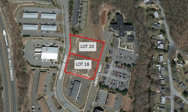
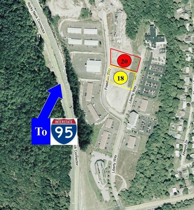
Property Record
18 Liberty Way, Niantic, CT 06357

NEARBY LISTINGS FOR SALE OR LEASE
-
-
View all Niantic listings for sale on LoopNet.com
Property Detail
18 Liberty Way
ELYM-000904-005001
New London
Industrialacreage
Connecticut
X
0.93 AC
09011C0478J
SW New London/East Lyme
2025
Hartford
2025
Norwich-New London-Willimantic, CT
716101
DEMOGRAPHICS near 18 Liberty Way
1 mile
3 mile
5 mile
2024 Total Population
2,407
17,566
32,008
2029 Population
2,447
17,907
32,378
Pop Growth 2024-2029
+ 1.66%
+ 1.94%
+ 1.16%
Average Age
45
47
47
2024 Total Households
712
7,459
13,504
HH Growth 2024-2029
+ 0.42%
+ 2.02%
+ 1.20%
Median Household Inc
$53,077
$103,181
$104,965
Avg Household Size
2.00
2.20
2.20
2024 Avg HH Vehicles
2.00
2.00
2.00
Median Home Value
$296,590
$369,988
$379,041
Median Year Built
1997
1967
1967
Nearby Places
Map Layers
Map Styles
 Street
 Aerial
Transit
 Traffic
 Biking
Places
Listings with unknown addresses are not visible on the map
- Restaurants
- Banks
- Shops
- Fitness
- Groceries
PUBLIC TRANSPORTATION
COMMUTER RAIL
Old Saybrook (Shore Line East - Shore Line East)
Drive
Walk
Distance
Old Saybrook (Shore Line East - Shore Line East)
13 min
8.7 mi
AIRPORT
Tweed/New Haven
Drive
Walk
Distance
Tweed/New Haven
51 min
37.1 mi
Freight Ports
Port of New Haven
Drive
Walk
Distance
Port of New Haven
48 min
36.8 mi
SALE & LEASE HISTORY
LISTING DATE
SALE/LEASE

Sep 24, 2016
For Sale
Nearby Properties
Address
Land Use
TOTAL SIZE
Lot Size
Zoning
Address
Land Use
TOTAL SIZE
Lot Size
Zoning
66.17 AC
LI
Address
Land Use
TOTAL SIZE
Lot Size
Zoning
1,256 SF
64.84 AC
R40
Address
Land Use
TOTAL SIZE
Lot Size
Zoning
617.95 AC
Address
Land Use
TOTAL SIZE
Lot Size
Zoning
511.78 AC
R40
Address
Land Use
TOTAL SIZE
Lot Size
Zoning
68.87 AC
GDPP
Address
Land Use
TOTAL SIZE
Lot Size
Zoning
106 AC
R40
Address
Land Use
TOTAL SIZE
Lot Size
Zoning
122,580 SF
15.18 AC
Address
Land Use
TOTAL SIZE
Lot Size
Zoning
55,906 SF
2.16 AC
CB
Address
Land Use
TOTAL SIZE
Lot Size
Zoning
67,784 SF
5.53 AC
CA
Address
Land Use
TOTAL SIZE
Lot Size
Zoning
18.40 AC
R80
Address
Land Use
TOTAL SIZE
Lot Size
Zoning
51,544 SF
10.75 AC
RU40
Address
Land Use
TOTAL SIZE
Lot Size
Zoning
10.79 AC
R40
Address
Land Use
TOTAL SIZE
Lot Size
Zoning
23.41 AC
LI
Address
Land Use
TOTAL SIZE
Lot Size
Zoning
3.29 AC
CB
Address
Land Use
TOTAL SIZE
Lot Size
Zoning
56,568 SF
3.65 AC
LI
Address
Land Use
TOTAL SIZE
Lot Size
Zoning
29,830 SF
4.85 AC
LI
Address
Land Use
TOTAL SIZE
Lot Size
Zoning
57,298 SF
2.13 AC
CA
Address
Land Use
TOTAL SIZE
Lot Size
Zoning
11.62 AC
LI80
Address
Land Use
TOTAL SIZE
Lot Size
Zoning
25,088 SF
8.10 AC
LI80
Address
Land Use
TOTAL SIZE
Lot Size
Zoning
5.01 AC
IND
Address
Land Use
TOTAL SIZE
Lot Size
Zoning
9,814 SF
1.44 AC
R40
Address
Land Use
TOTAL SIZE
Lot Size
Zoning
4,958 SF
0.96 AC
RU40
Address
Land Use
TOTAL SIZE
Lot Size
Zoning
38,837 SF
2.15 AC
R40
Address
Land Use
TOTAL SIZE
Lot Size
Zoning
27,356 SF
0.95 AC
CB
Address
Land Use
TOTAL SIZE
Lot Size
Zoning
1.97 AC
CM
Address
Land Use
TOTAL SIZE
Lot Size
Zoning
41,563 SF
4.20 AC
Address
Land Use
TOTAL SIZE
Lot Size
Zoning
7,090 SF
1.07 AC
R40
Address
Land Use
TOTAL SIZE
Lot Size
Zoning
0.93 AC
RU40
Address
Land Use
TOTAL SIZE
Lot Size
Zoning
7,565 SF
1.87 AC
R40
Address
Land Use
TOTAL SIZE
Lot Size
Zoning
43,175 SF
3.83 AC
R40
The World's #1 Commercial Real Estate Marketplace
Connect with us
© 2026 CoStar Group
The information above has been obtained from sources believed reliable. While we do not doubt its accuracy we have not verified it and make no guarantee, warranty or representation about it. It is your responsibility to independently confirm its accuracy and completeness. Any projections, opinions, assumptions, or estimates used are for example only and do not represent the current or future performance of the property. The value of this transaction to you depends on tax and other factors which should be evaluated by your tax, financial, and legal advisors. You and your advisors should conduct a careful, independent investigation of the property to determine to your satisfaction the suitability of the property for your needs.