Property Record
18 Main St, Acton, MA 01720
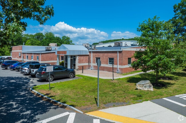


Property Detail
18 Main St
ACTO-000002I-000033
MIDDLESEX
Storebuilding
Massachusetts
LI
3
AE The base floodplain where base flood elevations are provided. AE Zones are now used on new format FIRMs instead of A1-A30 Zones.
1.85 AC
2025
Concord/Maynard
2025
Boston
363103
Boston-Cambridge-Newton, MA-NH
43,200 SF
NEARBY LISTINGS FOR SALE OR LEASE
DEMOGRAPHICS near 18 Main St
1 mile
3 mile
5 mile
2025 Total Population
5,090
36,242
72,430
2030 Population
5,273
37,754
75,596
Pop Growth 2025-2030
+ 3.60%
+ 4.17%
+ 4.37%
Average Age
43
42
43
2025 Total Households
2,009
13,862
27,097
HH Growth 2025-2030
+ 3.63%
+ 4.29%
+ 4.52%
Median Household Inc
$123,898
$159,136
$183,154
Avg Household Size
2.50
2.60
2.60
2025 Avg HH Vehicles
2.00
2.00
2.00
Median Home Value
$631,164
$732,674
$802,087
Median Year Built
1968
1968
1973
Nearby Places
Map Layers
Map Styles
 Street
 Aerial
Transit
 Traffic
 Biking
Places
Listings with unknown addresses are not visible on the map
- Restaurants
- Banks
- Shops
- Fitness
- Groceries
PUBLIC TRANSPORTATION
COMMUTER RAIL
South Acton (Fitchburg/South Acton Line - Massachusetts Bay Transportation Authority Commuter Rail (Purple Line))
Drive
Walk
Distance
South Acton (Fitchburg/South Acton Line - Massachusetts Bay Transportation Authority Commuter Rail (Purple Line))
3 min
19 min
1.0 mi
West Concord (Fitchburg/South Acton Line - Massachusetts Bay Transportation Authority Commuter Rail (Purple Line))
Drive
Walk
Distance
West Concord (Fitchburg/South Acton Line - Massachusetts Bay Transportation Authority Commuter Rail (Purple Line))
10 min
4.9 mi
AIRPORT
General Edward Lawrence Logan International
Drive
Walk
Distance
General Edward Lawrence Logan International
47 min
28.3 mi
Worcester Regional
Drive
Walk
Distance
Worcester Regional
50 min
30.6 mi
Freight Ports
Port of Boston
Drive
Walk
Distance
Port of Boston
46 min
28.4 mi
SALE & LEASE HISTORY
LISTING DATE
SALE/LEASE

Sep 25, 2016
For Lease
Jun 28, 2018
For Lease
Feb 02, 2018
For Lease
Dec 08, 2020
For Lease
Nearby Properties
Address
Land Use
TOTAL SIZE
Lot Size
Zoning
Address
Land Use
TOTAL SIZE
Lot Size
Zoning
30.39 AC
I
Address
Land Use
TOTAL SIZE
Lot Size
Zoning
197,727 SF
31.55 AC
R2
Address
Land Use
TOTAL SIZE
Lot Size
Zoning
160 SF
R1
Address
Land Use
TOTAL SIZE
Lot Size
Zoning
263,589 SF
8.76 AC
R2
Address
Land Use
TOTAL SIZE
Lot Size
Zoning
326,464 SF
19.52 AC
I
Address
Land Use
TOTAL SIZE
Lot Size
Zoning
25.15 AC
R2
Address
Land Use
TOTAL SIZE
Lot Size
Zoning
77,323 SF
18 AC
C
Address
Land Use
TOTAL SIZE
Lot Size
Zoning
51,504 SF
18.87 AC
C
Address
Land Use
TOTAL SIZE
Lot Size
Zoning
7.88 AC
B
Address
Land Use
TOTAL SIZE
Lot Size
Zoning
155,339 SF
24 AC
R1
Address
Land Use
TOTAL SIZE
Lot Size
Zoning
35.99 AC
HI
Address
Land Use
TOTAL SIZE
Lot Size
Zoning
104,150 SF
14.98 AC
R
Address
Land Use
TOTAL SIZE
Lot Size
Zoning
20,498 SF
25.75 AC
GI
Address
Land Use
TOTAL SIZE
Lot Size
Zoning
9.56 AC
PM
Address
Land Use
TOTAL SIZE
Lot Size
Zoning
815 AC
OS
Address
Land Use
TOTAL SIZE
Lot Size
Zoning
13.19 AC
B
Address
Land Use
TOTAL SIZE
Lot Size
Zoning
54,892 SF
7.99 AC
AA
Address
Land Use
TOTAL SIZE
Lot Size
Zoning
131,607 SF
36.01 AC
Address
Land Use
TOTAL SIZE
Lot Size
Zoning
105,036 SF
6.84 AC
KC
Address
Land Use
TOTAL SIZE
Lot Size
Zoning
39,250 SF
0.39 AC
R2
Address
Land Use
TOTAL SIZE
Lot Size
Zoning
55.50 AC
ARC
Address
Land Use
TOTAL SIZE
Lot Size
Zoning
76,623 SF
16.59 AC
R2
Address
Land Use
TOTAL SIZE
Lot Size
Zoning
40 AC
R2
Address
Land Use
TOTAL SIZE
Lot Size
Zoning
33.05 AC
I
Address
Land Use
TOTAL SIZE
Lot Size
Zoning
72,821 SF
16.56 AC
R
Address
Land Use
TOTAL SIZE
Lot Size
Zoning
26.16 AC
R2
Address
Land Use
TOTAL SIZE
Lot Size
Zoning
56,036 SF
17.13 AC
R2
Address
Land Use
TOTAL SIZE
Lot Size
Zoning
40.44 AC
ARC
Address
Land Use
TOTAL SIZE
Lot Size
Zoning
105,163 SF
10.65 AC
OP2
Address
Land Use
TOTAL SIZE
Lot Size
Zoning
85,000 SF
18.77 AC
R1
The World's #1 Commercial Real Estate Marketplace
Connect with us
© 2026 CoStar Group
The information above has been obtained from sources believed reliable. While we do not doubt its accuracy we have not verified it and make no guarantee, warranty or representation about it. It is your responsibility to independently confirm its accuracy and completeness. Any projections, opinions, assumptions, or estimates used are for example only and do not represent the current or future performance of the property. The value of this transaction to you depends on tax and other factors which should be evaluated by your tax, financial, and legal advisors. You and your advisors should conduct a careful, independent investigation of the property to determine to your satisfaction the suitability of the property for your needs.