Property Record
18 Talbot Ave, Dorchester Center, MA 02124
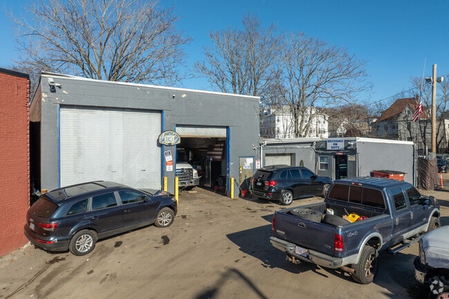
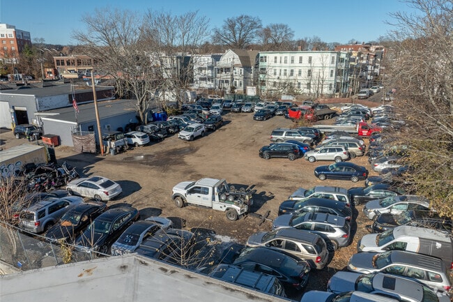
This Property Is For Sale
NEARBY LISTINGS FOR SALE OR LEASE
Property Detail
18 Talbot Ave
DORC-000000-000014-002027
Suffolk
Autorepair
Massachusetts
X
0.07 AC
25025C0087G
Roxbury/Dorchester
2025
Boston
2025
Boston-Cambridge-Newton, MA-NH
092400
DEMOGRAPHICS near 18 Talbot Ave
1 Mile
3 Mile
5 Mile
2024 Total Population
42,308
301,299
727,141
2029 Population
39,827
283,975
701,101
Pop Growth 2024-2029
(5.86%)
(5.75%)
(3.58%)
Average Age
37
39
38
2024 Total Households
13,964
113,357
297,551
HH Growth 2024-2029
(6.77%)
(6.52%)
(3.87%)
Median Household Inc
$48,166
$69,375
$88,204
Avg Household Size
2.80
2.50
2.20
2024 Avg HH Vehicles
1.00
1.00
1.00
Median Home Value
$568,658
$656,574
$753,474
Median Year Built
1948
1948
1951
Nearby Places
- Restaurants
- Banks
- Shops
- Fitness
- Groceries
PUBLIC TRANSPORTATION
COMMUTER RAIL
Talbot Avenue (Fairmount Line - MBTA, Franklin/Foxboro Line - MBTA)
DRIVE
WALK
Distance
Talbot Avenue (Fairmount Line - MBTA, Franklin/Foxboro Line - MBTA)
1 min
10 min
0.5 mi
Four Corners/Geneva (Fairmount Line - MBTA, Franklin/Foxboro Line - MBTA)
DRIVE
WALK
Distance
Four Corners/Geneva (Fairmount Line - MBTA, Franklin/Foxboro Line - MBTA)
2 min
1.3 mi
AIRPORT
General Edward Lawrence Logan International
DRIVE
WALK
Distance
General Edward Lawrence Logan International
15 min
8.0 mi
Freight Ports
Port of Boston
DRIVE
WALK
Distance
Port of Boston
12 min
5.7 mi
Nearby Properties
Address
Land Use
TOTAL SIZE
Lot Size
Zoning
Address
Land Use
TOTAL SIZE
Lot Size
Zoning
909,764 SF
25.13 AC
E
Address
Land Use
TOTAL SIZE
Lot Size
Zoning
254,208 SF
3.83 AC
E
Address
Land Use
TOTAL SIZE
Lot Size
Zoning
262,120 SF
0.62 AC
C
Address
Land Use
TOTAL SIZE
Lot Size
Zoning
259,990 SF
2.84 AC
E
Address
Land Use
TOTAL SIZE
Lot Size
Zoning
547,851 SF
8.14 AC
E
Address
Land Use
TOTAL SIZE
Lot Size
Zoning
305,455 SF
0.54 AC
RC
Address
Land Use
TOTAL SIZE
Lot Size
Zoning
303,055 SF
2.15 AC
RC
Address
Land Use
TOTAL SIZE
Lot Size
Zoning
468,308 SF
0.78 AC
E
Address
Land Use
TOTAL SIZE
Lot Size
Zoning
249,135 SF
1.99 AC
RC
Address
Land Use
TOTAL SIZE
Lot Size
Zoning
522,465 SF
5.34 AC
E
Address
Land Use
TOTAL SIZE
Lot Size
Zoning
76,658 SF
0.38 AC
E
Address
Land Use
TOTAL SIZE
Lot Size
Zoning
432,703 SF
10.46 AC
E
Address
Land Use
TOTAL SIZE
Lot Size
Zoning
146,751 SF
3.39 AC
E
Address
Land Use
TOTAL SIZE
Lot Size
Zoning
428,271 SF
9.65 AC
E
Address
Land Use
TOTAL SIZE
Lot Size
Zoning
14.59 AC
S40
Address
Land Use
TOTAL SIZE
Lot Size
Zoning
243,570 SF
0.94 AC
E
Address
Land Use
TOTAL SIZE
Lot Size
Zoning
139,965 SF
9.27 AC
E
Address
Land Use
TOTAL SIZE
Lot Size
Zoning
45,000 SF
14.30 AC
E
Address
Land Use
TOTAL SIZE
Lot Size
Zoning
351,680 SF
4.01 AC
RC
Address
Land Use
TOTAL SIZE
Lot Size
Zoning
103,544 SF
0.61 AC
E
Address
Land Use
TOTAL SIZE
Lot Size
Zoning
255,257 SF
2.34 AC
A
Address
Land Use
TOTAL SIZE
Lot Size
Zoning
1,940 SF
58.17 AC
E
Address
Land Use
TOTAL SIZE
Lot Size
Zoning
681,518 SF
34.52 AC
Address
Land Use
TOTAL SIZE
Lot Size
Zoning
240.18 AC
E
Address
Land Use
TOTAL SIZE
Lot Size
Zoning
291,918 SF
1.99 AC
RC
Address
Land Use
TOTAL SIZE
Lot Size
Zoning
43,880 SF
0.68 AC
E
Address
Land Use
TOTAL SIZE
Lot Size
Zoning
0.54 AC
E
Address
Land Use
TOTAL SIZE
Lot Size
Zoning
332,366 SF
4.86 AC
E
Address
Land Use
TOTAL SIZE
Lot Size
Zoning
728,348 SF
11.71 AC
C
Address
Land Use
TOTAL SIZE
Lot Size
Zoning
273,051 SF
5.41 AC
E
The World's #1 Commercial Real Estate Marketplace
Connect with us
© 2025 CoStar Group
The information above has been obtained from sources believed reliable. While we do not doubt its accuracy we have not verified it and make no guarantee, warranty or representation about it. It is your responsibility to independently confirm its accuracy and completeness. Any projections, opinions, assumptions, or estimates used are for example only and do not represent the current or future performance of the property. The value of this transaction to you depends on tax and other factors which should be evaluated by your tax, financial, and legal advisors. You and your advisors should conduct a careful, independent investigation of the property to determine to your satisfaction the suitability of the property for your needs.