Property Record
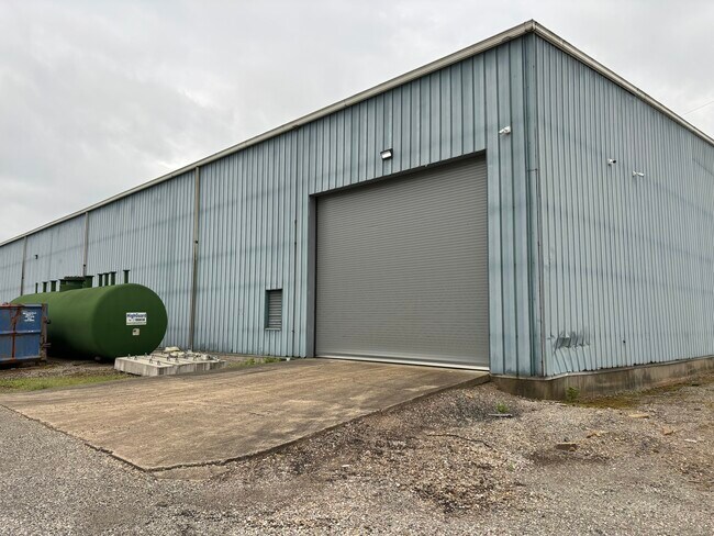
18 Th St, Bellaire, OH 43906

Property Detail
18 Th St
Wheeling, WV-OH
IN-LOT 51A F 3 N PT 67 X 50
29-03751-000
BELMONT
Industrialgeneral
Ohio
AE The base floodplain where base flood elevations are provided. AE Zones are now used on new format FIRMs instead of A1-A30 Zones.
51a
2025
0.03 AC
2025
Ohio South Area
011400
Other Market Areas
NEARBY LISTINGS FOR SALE OR LEASE
DEMOGRAPHICS near 18 Th St
1 mile
3 mile
5 mile
2025 Total Population
2,520
16,809
36,286
2030 Population
2,490
16,545
35,657
Pop Growth 2025-2030
(1.19%)
(1.57%)
(1.73%)
Average Age
43
43
44
2025 Total Households
1,191
7,342
16,156
HH Growth 2025-2030
(1.18%)
(1.57%)
(1.70%)
Median Household Inc
$33,772
$47,685
$49,069
Avg Household Size
2.10
2.20
2.20
2025 Avg HH Vehicles
1.00
2.00
2.00
Median Home Value
$87,350
$113,807
$130,671
Median Year Built
1952
1951
1953
Nearby Places
Map Layers
Map Styles
 Street
 Aerial
Layers
 Traffic
 Biking
Places
Listings with unknown addresses are not visible on the map
- Restaurants
- Banks
- Shops
- Fitness
- Groceries
SALE & LEASE HISTORY
LISTING DATE
SALE/LEASE

Jul 30, 2024
For Lease
Jul 30, 2024
For Sale
Nearby Properties
Address
Land Use
TOTAL SIZE
Lot Size
Zoning
Address
Land Use
TOTAL SIZE
Lot Size
Zoning
21.75 AC
Address
Land Use
TOTAL SIZE
Lot Size
Zoning
264,400 SF
17.84 AC
Address
Land Use
TOTAL SIZE
Lot Size
Zoning
Address
Land Use
TOTAL SIZE
Lot Size
Zoning
7.59 AC
Address
Land Use
TOTAL SIZE
Lot Size
Zoning
123,016 SF
0.55 AC
Address
Land Use
TOTAL SIZE
Lot Size
Zoning
112,314 SF
2.35 AC
Address
Land Use
TOTAL SIZE
Lot Size
Zoning
6.45 AC
Address
Land Use
TOTAL SIZE
Lot Size
Zoning
82,026 SF
10.21 AC
Address
Land Use
TOTAL SIZE
Lot Size
Zoning
7.68 AC
Address
Land Use
TOTAL SIZE
Lot Size
Zoning
31,380 SF
0.27 AC
Address
Land Use
TOTAL SIZE
Lot Size
Zoning
69,020 SF
4.55 AC
Address
Land Use
TOTAL SIZE
Lot Size
Zoning
30,115 SF
0.70 AC
Address
Land Use
TOTAL SIZE
Lot Size
Zoning
30,814 SF
8.97 AC
Address
Land Use
TOTAL SIZE
Lot Size
Zoning
0.92 AC
Address
Land Use
TOTAL SIZE
Lot Size
Zoning
3,012,287 SF
3.19 AC
Address
Land Use
TOTAL SIZE
Lot Size
Zoning
0.12 AC
Address
Land Use
TOTAL SIZE
Lot Size
Zoning
2.89 AC
Address
Land Use
TOTAL SIZE
Lot Size
Zoning
0.23 AC
Address
Land Use
TOTAL SIZE
Lot Size
Zoning
56,603 SF
7.19 AC
Address
Land Use
TOTAL SIZE
Lot Size
Zoning
65,365 SF
8.39 AC
Address
Land Use
TOTAL SIZE
Lot Size
Zoning
Address
Land Use
TOTAL SIZE
Lot Size
Zoning
76,600 SF
0.64 AC
Address
Land Use
TOTAL SIZE
Lot Size
Zoning
10.33 AC
Address
Land Use
TOTAL SIZE
Lot Size
Zoning
45,024 SF
0.60 AC
Address
Land Use
TOTAL SIZE
Lot Size
Zoning
27.78 AC
Address
Land Use
TOTAL SIZE
Lot Size
Zoning
13,755 SF
0.28 AC
Address
Land Use
TOTAL SIZE
Lot Size
Zoning
32,135 SF
2.86 AC
Address
Land Use
TOTAL SIZE
Lot Size
Zoning
31,200 SF
4.50 AC
Address
Land Use
TOTAL SIZE
Lot Size
Zoning
56,756 SF
0.65 AC
Address
Land Use
TOTAL SIZE
Lot Size
Zoning
1.05 AC
The World's #1 Commercial Real Estate Marketplace
Connect with us
© 2026 CoStar Group
The information above has been obtained from sources believed reliable. While we do not doubt its accuracy we have not verified it and make no guarantee, warranty or representation about it. It is your responsibility to independently confirm its accuracy and completeness. Any projections, opinions, assumptions, or estimates used are for example only and do not represent the current or future performance of the property. The value of this transaction to you depends on tax and other factors which should be evaluated by your tax, financial, and legal advisors. You and your advisors should conduct a careful, independent investigation of the property to determine to your satisfaction the suitability of the property for your needs.