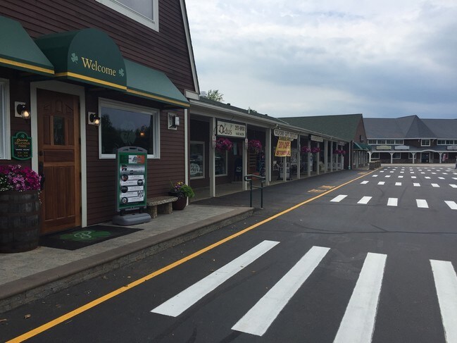
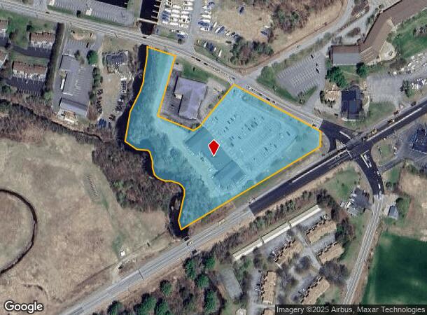
Property Record
18 Weirs Rd, Gilford, NH 03249
NEARBY LISTINGS FOR SALE OR LEASE
Property Detail
18 Weirs Rd
GIFL-000224-000003
Belknap
Commercialnec
New Hampshire
2024
5.67 AC
2024
Concord/New Hampshire North Area
966401
Other Market Areas
2,118 SF
Laconia, NH
DEMOGRAPHICS near 18 Weirs Rd
1 Mile
3 Mile
5 Mile
2024 Total Population
1,234
7,994
25,151
2029 Population
1,323
8,667
26,779
Pop Growth 2024-2029
+ 7.21%
+ 8.42%
+ 6.47%
Average Age
49
49
47
2024 Total Households
585
3,667
11,337
HH Growth 2024-2029
+ 7.01%
+ 8.45%
+ 6.42%
Median Household Inc
$86,413
$105,400
$81,404
Avg Household Size
2.10
2.20
2.20
2024 Avg HH Vehicles
2.00
2.00
2.00
Median Home Value
$448,148
$374,407
$334,068
Median Year Built
1984
1983
1979
Nearby Places
Map Layers
Map Styles
 Street
 Aerial
- Restaurants
- Banks
- Shops
- Fitness
- Groceries
SALE & LEASE HISTORY
LISTING DATE
SALE/LEASE

Sep 25, 2016
For Lease
Apr 15, 2023
For Lease
Nearby Properties
Address
Land Use
TOTAL SIZE
Lot Size
Zoning
Address
Land Use
TOTAL SIZE
Lot Size
Zoning
57.90 AC
C
Address
Land Use
TOTAL SIZE
Lot Size
Zoning
26 AC
SFR
Address
Land Use
TOTAL SIZE
Lot Size
Zoning
21.50 AC
C
Address
Land Use
TOTAL SIZE
Lot Size
Zoning
9.63 AC
C
Address
Land Use
TOTAL SIZE
Lot Size
Zoning
18.80 AC
SFR
Address
Land Use
TOTAL SIZE
Lot Size
Zoning
85 AC
SFR
Address
Land Use
TOTAL SIZE
Lot Size
Zoning
343.45 AC
I
Address
Land Use
TOTAL SIZE
Lot Size
Zoning
104,952 SF
5.10 AC
C
Address
Land Use
TOTAL SIZE
Lot Size
Zoning
31 AC
SFR
Address
Land Use
TOTAL SIZE
Lot Size
Zoning
0.62 AC
SFR
Address
Land Use
TOTAL SIZE
Lot Size
Zoning
15,086 SF
4.82 AC
CR
Address
Land Use
TOTAL SIZE
Lot Size
Zoning
8,318 SF
0.77 AC
SFR
Address
Land Use
TOTAL SIZE
Lot Size
Zoning
Address
Land Use
TOTAL SIZE
Lot Size
Zoning
10 AC
C
Address
Land Use
TOTAL SIZE
Lot Size
Zoning
528 SF
17 AC
UC
Address
Land Use
TOTAL SIZE
Lot Size
Zoning
1.60 AC
SFR
Address
Land Use
TOTAL SIZE
Lot Size
Zoning
2,860 SF
1.70 AC
SFR
Address
Land Use
TOTAL SIZE
Lot Size
Zoning
6.60 AC
SFR
Address
Land Use
TOTAL SIZE
Lot Size
Zoning
0.92 AC
RC
Address
Land Use
TOTAL SIZE
Lot Size
Zoning
968 SF
1.39 AC
SFR
Address
Land Use
TOTAL SIZE
Lot Size
Zoning
23 AC
SFR
Address
Land Use
TOTAL SIZE
Lot Size
Zoning
99.90 AC
NRR
Address
Land Use
TOTAL SIZE
Lot Size
Zoning
4,345 SF
1.10 AC
SFR
Address
Land Use
TOTAL SIZE
Lot Size
Zoning
6,070 SF
0.80 AC
SFR
Address
Land Use
TOTAL SIZE
Lot Size
Zoning
34 AC
SFR
Address
Land Use
TOTAL SIZE
Lot Size
Zoning
4.50 AC
RC
Address
Land Use
TOTAL SIZE
Lot Size
Zoning
17 AC
RC
Address
Land Use
TOTAL SIZE
Lot Size
Zoning
5.88 AC
C
Address
Land Use
TOTAL SIZE
Lot Size
Zoning
378.13 AC
NRR
Address
Land Use
TOTAL SIZE
Lot Size
Zoning
8.22 AC
RC
The World's #1 Commercial Real Estate Marketplace
Connect with us
© 2026 CoStar Group
The information above has been obtained from sources believed reliable. While we do not doubt its accuracy we have not verified it and make no guarantee, warranty or representation about it. It is your responsibility to independently confirm its accuracy and completeness. Any projections, opinions, assumptions, or estimates used are for example only and do not represent the current or future performance of the property. The value of this transaction to you depends on tax and other factors which should be evaluated by your tax, financial, and legal advisors. You and your advisors should conduct a careful, independent investigation of the property to determine to your satisfaction the suitability of the property for your needs.