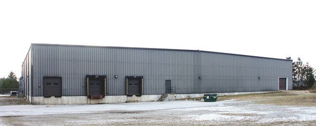
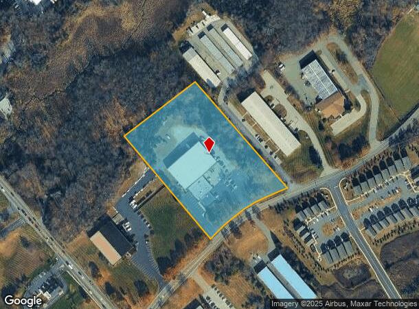
Property Record
18 White Lake Rd, Sparta, NJ 07871
NEARBY LISTINGS FOR SALE OR LEASE
Property Detail
18 White Lake Rd
18-13001-0000-00037
White Lake Road
Warehouse
Sussex
X
New Jersey
34037C0308E
37
2024
4.88 AC
2025
Sussex County
373100
Northern New Jersey
29,422 SF
Newark, NJ-PA
DEMOGRAPHICS near 18 White Lake Rd
1 Mile
3 Mile
5 Mile
2024 Total Population
609
7,148
32,218
2029 Population
628
7,244
32,552
Pop Growth 2024-2029
+ 3.12%
+ 1.34%
+ 1.04%
Average Age
40
42
43
2024 Total Households
202
2,424
12,031
HH Growth 2024-2029
+ 3.47%
+ 1.24%
+ 1.04%
Median Household Inc
$144,444
$142,562
$109,865
Avg Household Size
2.90
2.90
2.60
2024 Avg HH Vehicles
2.00
2.00
2.00
Median Home Value
$445,652
$439,762
$363,599
Median Year Built
1987
1985
1971
Nearby Places
Map Layers
Map Styles
 Street
 Aerial
- Restaurants
- Banks
- Shops
- Fitness
- Groceries
SALE & LEASE HISTORY
LISTING DATE
SALE/LEASE

Sep 24, 2016
For Lease
Nearby Properties
Address
Land Use
TOTAL SIZE
Lot Size
Zoning
Address
Land Use
TOTAL SIZE
Lot Size
Zoning
134,375 SF
27.71 AC
OSGU
Address
Land Use
TOTAL SIZE
Lot Size
Zoning
156,719 SF
48.98 AC
OSGU
Address
Land Use
TOTAL SIZE
Lot Size
Zoning
28.91 AC
PVC
Address
Land Use
TOTAL SIZE
Lot Size
Zoning
2.02 AC
PVC
Address
Land Use
TOTAL SIZE
Lot Size
Zoning
50,659 SF
9.90 AC
C-2
Address
Land Use
TOTAL SIZE
Lot Size
Zoning
2.27 AC
PVC
Address
Land Use
TOTAL SIZE
Lot Size
Zoning
58,605 SF
28.29 AC
OSGU
Address
Land Use
TOTAL SIZE
Lot Size
Zoning
35,884 SF
4.73 AC
C-2
Address
Land Use
TOTAL SIZE
Lot Size
Zoning
29,156 SF
121.97 AC
L-1
Address
Land Use
TOTAL SIZE
Lot Size
Zoning
58.78 AC
PDRM
Address
Land Use
TOTAL SIZE
Lot Size
Zoning
15,400 SF
53.92 AC
PDRM
Address
Land Use
TOTAL SIZE
Lot Size
Zoning
65,064 SF
7.17 AC
L-1
Address
Land Use
TOTAL SIZE
Lot Size
Zoning
31,504 SF
3.06 AC
ED-1
Address
Land Use
TOTAL SIZE
Lot Size
Zoning
23,184 SF
82.13 AC
OSGU
Address
Land Use
TOTAL SIZE
Lot Size
Zoning
10 AC
RR
Address
Land Use
TOTAL SIZE
Lot Size
Zoning
59,919 SF
21.22 AC
R-2
Address
Land Use
TOTAL SIZE
Lot Size
Zoning
45,445 SF
8.65 AC
ED
Address
Land Use
TOTAL SIZE
Lot Size
Zoning
28,317 SF
1.36 AC
C-2
Address
Land Use
TOTAL SIZE
Lot Size
Zoning
6.08 AC
PVC
Address
Land Use
TOTAL SIZE
Lot Size
Zoning
4,160 SF
96.54 AC
OSGU
Address
Land Use
TOTAL SIZE
Lot Size
Zoning
24,461 SF
5 AC
TCPB
Address
Land Use
TOTAL SIZE
Lot Size
Zoning
23,776 SF
190.85 AC
R1
Address
Land Use
TOTAL SIZE
Lot Size
Zoning
70.27 AC
E-D
Address
Land Use
TOTAL SIZE
Lot Size
Zoning
8.56 AC
ED
Address
Land Use
TOTAL SIZE
Lot Size
Zoning
17,524 SF
160.18 AC
R-2
Address
Land Use
TOTAL SIZE
Lot Size
Zoning
24,000 SF
3.24 AC
ED
Address
Land Use
TOTAL SIZE
Lot Size
Zoning
16,384 SF
6.99 AC
ED-1
Address
Land Use
TOTAL SIZE
Lot Size
Zoning
11,276 SF
2 AC
RC-2
Address
Land Use
TOTAL SIZE
Lot Size
Zoning
3.79 AC
HC
Address
Land Use
TOTAL SIZE
Lot Size
Zoning
31,662 SF
4.25 AC
ED
The World's #1 Commercial Real Estate Marketplace
Connect with us
© 2025 CoStar Group
The information above has been obtained from sources believed reliable. While we do not doubt its accuracy we have not verified it and make no guarantee, warranty or representation about it. It is your responsibility to independently confirm its accuracy and completeness. Any projections, opinions, assumptions, or estimates used are for example only and do not represent the current or future performance of the property. The value of this transaction to you depends on tax and other factors which should be evaluated by your tax, financial, and legal advisors. You and your advisors should conduct a careful, independent investigation of the property to determine to your satisfaction the suitability of the property for your needs.