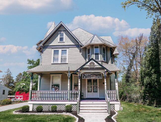
Property Record
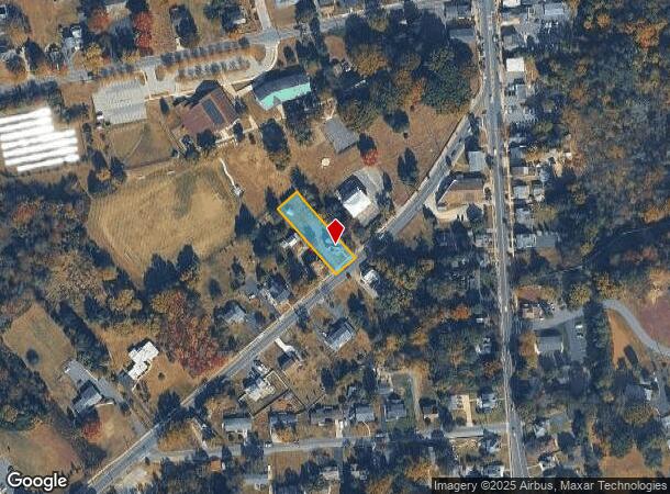
18 Woodstown Rd, Mullica Hill, NJ 08062
NEARBY LISTINGS FOR SALE OR LEASE
Property Detail
18 Woodstown Rd
08-00069-0000-00004
Nancy M & Paul W Hengel
Commercialnec
Gloucester
X
New Jersey
34015C0176E
4
2024
0.39 AC
2025
Gloucester County
502001
Philadelphia
2,535 SF
Philadelphia-Camden-Wilmington, PA-NJ-DE-MD
DEMOGRAPHICS near 18 Woodstown Rd
1 Mile
3 Mile
5 Mile
2024 Total Population
4,902
16,068
49,996
2029 Population
5,032
16,495
51,514
Pop Growth 2024-2029
+ 2.65%
+ 2.66%
+ 3.04%
Average Age
41
39
40
2024 Total Households
1,792
5,190
17,590
HH Growth 2024-2029
+ 2.68%
+ 2.68%
+ 3.12%
Median Household Inc
$114,754
$151,878
$119,637
Avg Household Size
2.70
3.00
2.80
2024 Avg HH Vehicles
2.00
2.00
2.00
Median Home Value
$423,967
$456,249
$366,955
Median Year Built
1994
1995
1991
Nearby Places
Map Layers
Map Styles
 Street
 Aerial
- Restaurants
- Banks
- Shops
- Fitness
- Groceries
PUBLIC TRANSPORTATION
AIRPORT
Philadelphia International
DRIVE
WALK
Distance
Philadelphia International
37 min
21.6 mi
Freight Ports
Broadway Terminal - Pier 5
DRIVE
WALK
Distance
Broadway Terminal - Pier 5
26 min
16.6 mi
SALE & LEASE HISTORY
LISTING DATE
SALE/LEASE

May 20, 2024
For Sale
Nearby Properties
Address
Land Use
TOTAL SIZE
Lot Size
Zoning
Address
Land Use
TOTAL SIZE
Lot Size
Zoning
80.26 AC
INS
Address
Land Use
TOTAL SIZE
Lot Size
Zoning
13.76 AC
INS
Address
Land Use
TOTAL SIZE
Lot Size
Zoning
24.79 AC
R1
Address
Land Use
TOTAL SIZE
Lot Size
Zoning
5,893 SF
12.79 AC
INSH
Address
Land Use
TOTAL SIZE
Lot Size
Zoning
7.85 AC
R12
Address
Land Use
TOTAL SIZE
Lot Size
Zoning
13.20 AC
INS
Address
Land Use
TOTAL SIZE
Lot Size
Zoning
5.15 AC
C1
Address
Land Use
TOTAL SIZE
Lot Size
Zoning
3.90 AC
INS
Address
Land Use
TOTAL SIZE
Lot Size
Zoning
19.15 AC
INS
Address
Land Use
TOTAL SIZE
Lot Size
Zoning
23.26 AC
LI
Address
Land Use
TOTAL SIZE
Lot Size
Zoning
Address
Land Use
TOTAL SIZE
Lot Size
Zoning
5 AC
AR
Address
Land Use
TOTAL SIZE
Lot Size
Zoning
8 AC
C2
Address
Land Use
TOTAL SIZE
Lot Size
Zoning
4.73 AC
R1
Address
Land Use
TOTAL SIZE
Lot Size
Zoning
5.41 AC
LI
Address
Land Use
TOTAL SIZE
Lot Size
Zoning
2,984 SF
5.27 AC
R1
Address
Land Use
TOTAL SIZE
Lot Size
Zoning
9.59 AC
INS
Address
Land Use
TOTAL SIZE
Lot Size
Zoning
5.39 AC
C2
Address
Land Use
TOTAL SIZE
Lot Size
Zoning
6.66 AC
LI
Address
Land Use
TOTAL SIZE
Lot Size
Zoning
0.57 AC
C2
Address
Land Use
TOTAL SIZE
Lot Size
Zoning
3.70 AC
LI
Address
Land Use
TOTAL SIZE
Lot Size
Zoning
3.34 AC
LI
Address
Land Use
TOTAL SIZE
Lot Size
Zoning
15.76 AC
LI
Address
Land Use
TOTAL SIZE
Lot Size
Zoning
7.02 AC
C55
Address
Land Use
TOTAL SIZE
Lot Size
Zoning
10,112 SF
1.13 AC
C2
Address
Land Use
TOTAL SIZE
Lot Size
Zoning
12,040 SF
3.01 AC
Address
Land Use
TOTAL SIZE
Lot Size
Zoning
10,617 SF
17.22 AC
R1
Address
Land Use
TOTAL SIZE
Lot Size
Zoning
Address
Land Use
TOTAL SIZE
Lot Size
Zoning
4.07 AC
C55
Address
Land Use
TOTAL SIZE
Lot Size
Zoning
9,552 SF
1.40 AC
INS
The World's #1 Commercial Real Estate Marketplace
Connect with us
© 2025 CoStar Group
The information above has been obtained from sources believed reliable. While we do not doubt its accuracy we have not verified it and make no guarantee, warranty or representation about it. It is your responsibility to independently confirm its accuracy and completeness. Any projections, opinions, assumptions, or estimates used are for example only and do not represent the current or future performance of the property. The value of this transaction to you depends on tax and other factors which should be evaluated by your tax, financial, and legal advisors. You and your advisors should conduct a careful, independent investigation of the property to determine to your satisfaction the suitability of the property for your needs.