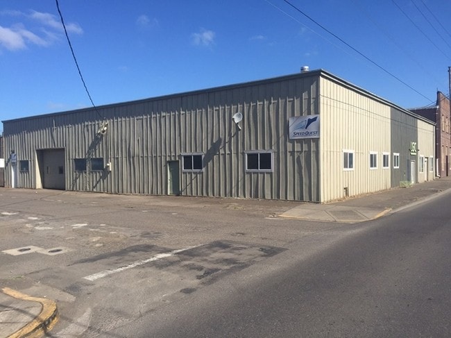
Property Record
170 S 3Rd St, Harrisburg, OR 97446

NEARBY LISTINGS FOR SALE OR LEASE
Property Detail
170 S 3Rd St
Albany, OR
Harrisburg, City Of
0327334
15S04W16AA
Commercialnec
Linn
X
Oregon
41003C0495F
10,11
2025
0.23 AC
2025
Linn County
030600
Portland
10,000 SF
DEMOGRAPHICS near 170 S 3Rd St
1 Mile
3 Mile
5 Mile
2024 Total Population
3,783
4,765
13,791
2029 Population
3,969
4,954
14,115
Pop Growth 2024-2029
+ 4.92%
+ 3.97%
+ 2.35%
Average Age
38
39
40
2024 Total Households
1,363
1,708
5,166
HH Growth 2024-2029
+ 5.06%
+ 4.10%
+ 2.28%
Median Household Inc
$42,851
$44,947
$56,946
Avg Household Size
2.80
2.80
2.60
2024 Avg HH Vehicles
2.00
2.00
2.00
Median Home Value
$312,848
$327,894
$340,425
Median Year Built
1990
1985
1979
Nearby Places
- Restaurants
- Banks
- Shops
- Fitness
- Groceries
PUBLIC TRANSPORTATION
AIRPORT
Mahlon Sweet Field
DRIVE
WALK
Distance
Mahlon Sweet Field
23 min
14.3 mi
Freight Ports
Port of Coos Bay, OR
DRIVE
WALK
Distance
Port of Coos Bay, OR
166 min
115.3 mi
SALE & LEASE HISTORY
LISTING DATE
SALE/LEASE

Sep 24, 2016
For Sale
Mar 22, 2024
For Lease
Nearby Properties
Address
Land Use
TOTAL SIZE
Lot Size
Zoning
Address
Land Use
TOTAL SIZE
Lot Size
Zoning
74,054 SF
10.49 AC
R-2
Address
Land Use
TOTAL SIZE
Lot Size
Zoning
13.32 AC
M-2
Address
Land Use
TOTAL SIZE
Lot Size
Zoning
6.72 AC
M-2
Address
Land Use
TOTAL SIZE
Lot Size
Zoning
22,144 SF
3.77 AC
R-2
Address
Land Use
TOTAL SIZE
Lot Size
Zoning
16.10 AC
UGA-LI
Address
Land Use
TOTAL SIZE
Lot Size
Zoning
2,016 SF
1.06 AC
C-1
Address
Land Use
TOTAL SIZE
Lot Size
Zoning
25.44 AC
UGA-HI
Address
Land Use
TOTAL SIZE
Lot Size
Zoning
27,042 SF
6.40 AC
R-1
Address
Land Use
TOTAL SIZE
Lot Size
Zoning
7.46 AC
M-1
Address
Land Use
TOTAL SIZE
Lot Size
Zoning
33,575 SF
5 AC
M-2
Address
Land Use
TOTAL SIZE
Lot Size
Zoning
18,264 SF
1.26 AC
R-2
Address
Land Use
TOTAL SIZE
Lot Size
Zoning
6.52 AC
M-2
Address
Land Use
TOTAL SIZE
Lot Size
Zoning
960 SF
0.97 AC
C-1
Address
Land Use
TOTAL SIZE
Lot Size
Zoning
9.23 AC
M-2
Address
Land Use
TOTAL SIZE
Lot Size
Zoning
5.92 AC
M-2
Address
Land Use
TOTAL SIZE
Lot Size
Zoning
14,400 SF
5.30 AC
M-2
Address
Land Use
TOTAL SIZE
Lot Size
Zoning
8,515 SF
2.61 AC
R-1
Address
Land Use
TOTAL SIZE
Lot Size
Zoning
1.93 AC
M-1
Address
Land Use
TOTAL SIZE
Lot Size
Zoning
15,054 SF
0.79 AC
C-1
Address
Land Use
TOTAL SIZE
Lot Size
Zoning
11,760 SF
1.50 AC
M-2
Address
Land Use
TOTAL SIZE
Lot Size
Zoning
5,558 SF
1.30 AC
M-2
Address
Land Use
TOTAL SIZE
Lot Size
Zoning
15,570 SF
1.26 AC
C-1
Address
Land Use
TOTAL SIZE
Lot Size
Zoning
3,677 SF
227.05 AC
E30
Address
Land Use
TOTAL SIZE
Lot Size
Zoning
31,028 SF
5.40 AC
AB
Address
Land Use
TOTAL SIZE
Lot Size
Zoning
1,194 SF
4.68 AC
UGA-LI
Address
Land Use
TOTAL SIZE
Lot Size
Zoning
34,486 SF
2.77 AC
R-2
Address
Land Use
TOTAL SIZE
Lot Size
Zoning
4,017 SF
11.45 AC
RR5
Address
Land Use
TOTAL SIZE
Lot Size
Zoning
4.31 AC
M-2
Address
Land Use
TOTAL SIZE
Lot Size
Zoning
2,487 SF
1.61 AC
C-1
Address
Land Use
TOTAL SIZE
Lot Size
Zoning
4.35 AC
LI
The World's #1 Commercial Real Estate Marketplace
Connect with us
© 2025 CoStar Group
The information above has been obtained from sources believed reliable. While we do not doubt its accuracy we have not verified it and make no guarantee, warranty or representation about it. It is your responsibility to independently confirm its accuracy and completeness. Any projections, opinions, assumptions, or estimates used are for example only and do not represent the current or future performance of the property. The value of this transaction to you depends on tax and other factors which should be evaluated by your tax, financial, and legal advisors. You and your advisors should conduct a careful, independent investigation of the property to determine to your satisfaction the suitability of the property for your needs.