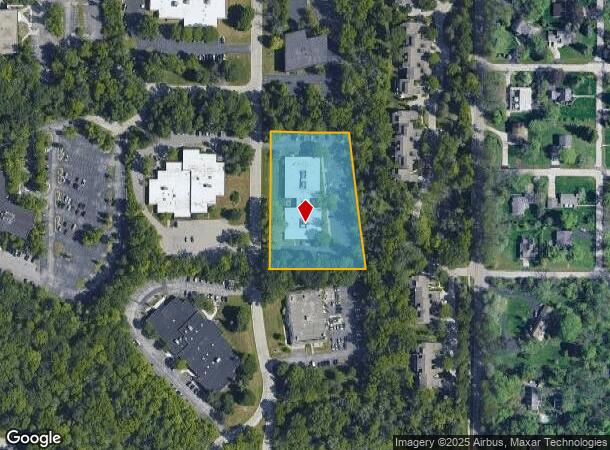
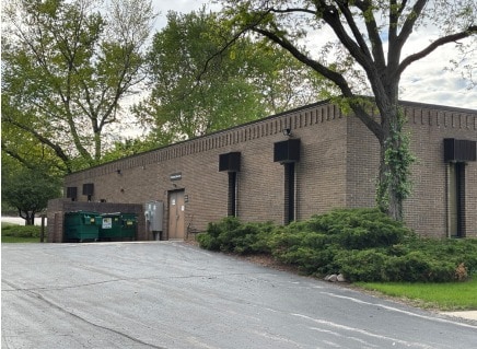
Property Record
180 Bishops Way, Brookfield, WI 53005


NEARBY LISTINGS FOR SALE OR LEASE
Property Detail
180 Bishops Way
Milwaukee-Waukesha-West Allis, WI
Certified Surv Map 1858
BRC-1107-999-005
PT SW1/4 SEC 25 T7N R20E PARCEL 6 CSM 1858 AS RECORDED V13 P20 DOC 853446 2.291 ACRES
Commercialnec
Waukesha
X
Wisconsin
55133C0237H
6
2024
2.25 AC
2024
Brookfield/New Berlin
201102
Milwaukee/Madison
DEMOGRAPHICS near 180 Bishops Way
1 Mile
3 Mile
5 Mile
2024 Total Population
6,982
64,525
229,789
2029 Population
7,256
65,579
230,089
Pop Growth 2024-2029
+ 3.92%
+ 1.63%
+ 0.13%
Average Age
45
42
42
2024 Total Households
2,910
28,163
100,752
HH Growth 2024-2029
+ 4.05%
+ 1.45%
(0.01%)
Median Household Inc
$98,307
$83,076
$78,476
Avg Household Size
2.30
2.20
2.20
2024 Avg HH Vehicles
2.00
2.00
2.00
Median Home Value
$340,569
$280,889
$264,468
Median Year Built
1966
1965
1959
Nearby Places
Map Layers
Map Styles
 Street
 Aerial
- Restaurants
- Banks
- Shops
- Fitness
- Groceries
PUBLIC TRANSPORTATION
COMMUTER RAIL
Milwaukee (Empire Builder - Amtrak)
DRIVE
WALK
Distance
Milwaukee (Empire Builder - Amtrak)
17 min
9.4 mi
AIRPORT
General Mitchell International
DRIVE
WALK
Distance
General Mitchell International
28 min
15.4 mi
Freight Ports
Port Milwaukee
DRIVE
WALK
Distance
Port Milwaukee
21 min
11.9 mi
SALE & LEASE HISTORY
LISTING DATE
SALE/LEASE

May 30, 2025
For Sale
Nearby Properties
Address
Land Use
TOTAL SIZE
Lot Size
Zoning
Address
Land Use
TOTAL SIZE
Lot Size
Zoning
70.73 AC
Address
Land Use
TOTAL SIZE
Lot Size
Zoning
8.63 AC
C2
Address
Land Use
TOTAL SIZE
Lot Size
Zoning
24.46 AC
Address
Land Use
TOTAL SIZE
Lot Size
Zoning
Address
Land Use
TOTAL SIZE
Lot Size
Zoning
19.25 AC
Address
Land Use
TOTAL SIZE
Lot Size
Zoning
23.16 AC
Address
Land Use
TOTAL SIZE
Lot Size
Zoning
4.54 AC
Address
Land Use
TOTAL SIZE
Lot Size
Zoning
12.50 AC
Address
Land Use
TOTAL SIZE
Lot Size
Zoning
20.02 AC
Address
Land Use
TOTAL SIZE
Lot Size
Zoning
4.99 AC
Address
Land Use
TOTAL SIZE
Lot Size
Zoning
Address
Land Use
TOTAL SIZE
Lot Size
Zoning
13.48 AC
Address
Land Use
TOTAL SIZE
Lot Size
Zoning
17.45 AC
Address
Land Use
TOTAL SIZE
Lot Size
Zoning
10.48 AC
Address
Land Use
TOTAL SIZE
Lot Size
Zoning
Address
Land Use
TOTAL SIZE
Lot Size
Zoning
10.22 AC
SP-RP
Address
Land Use
TOTAL SIZE
Lot Size
Zoning
Address
Land Use
TOTAL SIZE
Lot Size
Zoning
Address
Land Use
TOTAL SIZE
Lot Size
Zoning
3.55 AC
Address
Land Use
TOTAL SIZE
Lot Size
Zoning
1.84 AC
Address
Land Use
TOTAL SIZE
Lot Size
Zoning
230,726 SF
26.56 AC
RM1
Address
Land Use
TOTAL SIZE
Lot Size
Zoning
Address
Land Use
TOTAL SIZE
Lot Size
Zoning
4.79 AC
Address
Land Use
TOTAL SIZE
Lot Size
Zoning
4.53 AC
Address
Land Use
TOTAL SIZE
Lot Size
Zoning
Address
Land Use
TOTAL SIZE
Lot Size
Zoning
13.39 AC
Address
Land Use
TOTAL SIZE
Lot Size
Zoning
Address
Land Use
TOTAL SIZE
Lot Size
Zoning
106,495 SF
9.70 AC
PUD
Address
Land Use
TOTAL SIZE
Lot Size
Zoning
11.34 AC
Address
Land Use
TOTAL SIZE
Lot Size
Zoning
10.92 AC
The World's #1 Commercial Real Estate Marketplace
Connect with us
© 2025 CoStar Group
The information above has been obtained from sources believed reliable. While we do not doubt its accuracy we have not verified it and make no guarantee, warranty or representation about it. It is your responsibility to independently confirm its accuracy and completeness. Any projections, opinions, assumptions, or estimates used are for example only and do not represent the current or future performance of the property. The value of this transaction to you depends on tax and other factors which should be evaluated by your tax, financial, and legal advisors. You and your advisors should conduct a careful, independent investigation of the property to determine to your satisfaction the suitability of the property for your needs.