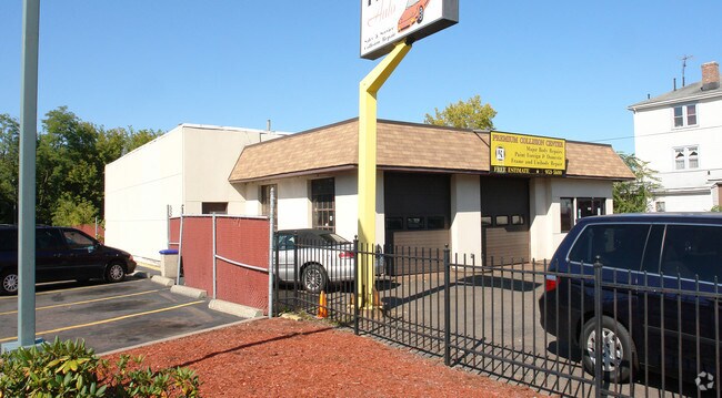
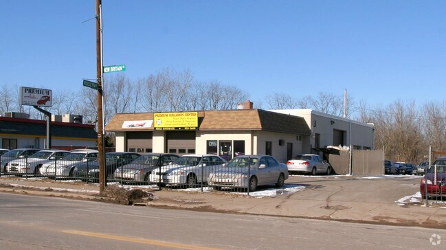
Property Record
180 Bloomfield Ave, Hartford, CT 06105
NEARBY LISTINGS FOR SALE OR LEASE
Property Detail
180 Bloomfield Ave
HTFD-000104-000001-000011
Hartford
Publicschool
Connecticut
AE
11
09003C0362F
72.46 AC
0
Hartford
2025
Hartford
510200
Hartford-West Hartford-East Hartford, CT
DEMOGRAPHICS near 180 Bloomfield Ave
1 Mile
3 Mile
5 Mile
2024 Total Population
12,033
140,216
279,593
2029 Population
11,917
139,148
277,940
Pop Growth 2024-2029
(0.96%)
(0.76%)
(0.59%)
Average Age
40
39
39
2024 Total Households
4,407
57,875
112,099
HH Growth 2024-2029
(1.04%)
(0.70%)
(0.51%)
Median Household Inc
$65,280
$61,304
$65,196
Avg Household Size
2.60
2.30
2.30
2024 Avg HH Vehicles
2.00
1.00
1.00
Median Home Value
$178,124
$260,390
$266,943
Median Year Built
1953
1952
1956
Nearby Places
Map Layers
Map Styles
 Street
 Aerial
- Restaurants
- Banks
- Shops
- Fitness
- Groceries
PUBLIC TRANSPORTATION
COMMUTER RAIL
Hartford (Hartford Line - Hartford Line)
DRIVE
WALK
Distance
Hartford (Hartford Line - Hartford Line)
5 min
2.9 mi
Hartford Amtrak Station (Amtrak Hartford Line - Amtrak, Northeast Regional - Amtrak, Valley Flyer - Amtrak, Vermonter - Amtrak)
DRIVE
WALK
Distance
Hartford Amtrak Station (Amtrak Hartford Line - Amtrak, Northeast Regional - Amtrak, Valley Flyer - Amtrak, Vermonter - Amtrak)
5 min
3.1 mi
AIRPORT
Bradley International
DRIVE
WALK
Distance
Bradley International
36 min
15.3 mi
Freight Ports
Port of New Haven
DRIVE
WALK
Distance
Port of New Haven
56 min
42.3 mi
Nearby Properties
Address
Land Use
TOTAL SIZE
Lot Size
Zoning
Address
Land Use
TOTAL SIZE
Lot Size
Zoning
88.48 AC
R-10
Address
Land Use
TOTAL SIZE
Lot Size
Zoning
173,601 SF
1.56 AC
DT-1
Address
Land Use
TOTAL SIZE
Lot Size
Zoning
482,566 SF
0.65 AC
DT-2
Address
Land Use
TOTAL SIZE
Lot Size
Zoning
4.13 AC
DT-1
Address
Land Use
TOTAL SIZE
Lot Size
Zoning
1.45 AC
CAMP
Address
Land Use
TOTAL SIZE
Lot Size
Zoning
213,017 SF
6.21 AC
DT-3
Address
Land Use
TOTAL SIZE
Lot Size
Zoning
2.90 AC
DT-2
Address
Land Use
TOTAL SIZE
Lot Size
Zoning
15,871 SF
42.80 AC
PO
Address
Land Use
TOTAL SIZE
Lot Size
Zoning
8.89 AC
MX-2
Address
Land Use
TOTAL SIZE
Lot Size
Zoning
29.35 AC
CAMP
Address
Land Use
TOTAL SIZE
Lot Size
Zoning
584 AC
OS
Address
Land Use
TOTAL SIZE
Lot Size
Zoning
1,125,149 SF
1.14 AC
DT-1
Address
Land Use
TOTAL SIZE
Lot Size
Zoning
5.56 AC
CAMP
Address
Land Use
TOTAL SIZE
Lot Size
Zoning
205,719 SF
12.15 AC
MX-2
Address
Land Use
TOTAL SIZE
Lot Size
Zoning
3,605 SF
28.33 AC
R-6,RM
Address
Land Use
TOTAL SIZE
Lot Size
Zoning
28.02 AC
CAMP
Address
Land Use
TOTAL SIZE
Lot Size
Zoning
416,762 SF
20 AC
CAMP
Address
Land Use
TOTAL SIZE
Lot Size
Zoning
7.45 AC
CAMP
Address
Land Use
TOTAL SIZE
Lot Size
Zoning
227,898 SF
5.33 AC
BCD
Address
Land Use
TOTAL SIZE
Lot Size
Zoning
310,901 SF
28.75 AC
MX-2
Address
Land Use
TOTAL SIZE
Lot Size
Zoning
15.31 AC
DDZ
Address
Land Use
TOTAL SIZE
Lot Size
Zoning
197,704 SF
1.82 AC
CAMP
Address
Land Use
TOTAL SIZE
Lot Size
Zoning
211,308 SF
55.90 AC
R-13
Address
Land Use
TOTAL SIZE
Lot Size
Zoning
40,632 SF
1.10 AC
NX-1
Address
Land Use
TOTAL SIZE
Lot Size
Zoning
4.76 AC
MX-2
Address
Land Use
TOTAL SIZE
Lot Size
Zoning
9,238 SF
28.35 AC
R-10,R
Address
Land Use
TOTAL SIZE
Lot Size
Zoning
6.63 AC
DT-1
Address
Land Use
TOTAL SIZE
Lot Size
Zoning
772,060 SF
17.90 AC
DDZ
Address
Land Use
TOTAL SIZE
Lot Size
Zoning
2.13 AC
DT-1
Address
Land Use
TOTAL SIZE
Lot Size
Zoning
4.50 AC
DT-1
The World's #1 Commercial Real Estate Marketplace
Connect with us
© 2025 CoStar Group
The information above has been obtained from sources believed reliable. While we do not doubt its accuracy we have not verified it and make no guarantee, warranty or representation about it. It is your responsibility to independently confirm its accuracy and completeness. Any projections, opinions, assumptions, or estimates used are for example only and do not represent the current or future performance of the property. The value of this transaction to you depends on tax and other factors which should be evaluated by your tax, financial, and legal advisors. You and your advisors should conduct a careful, independent investigation of the property to determine to your satisfaction the suitability of the property for your needs.