Property Record
180 Center Rd Se, Cartersville, GA 30121


Save to a Folder
{{folder.Name}}
{{folder.ListingIds.length}} Properties
{{folder.ListingIds.length}} Property
Create a New Folder
Property Detail
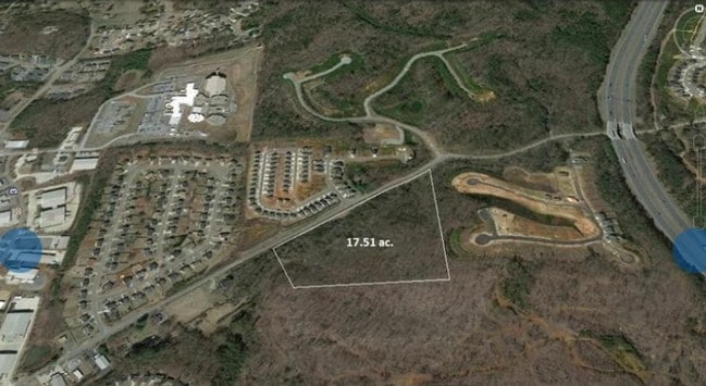
180 Center Rd Se
Atlanta-Sandy Springs-Roswell, GA
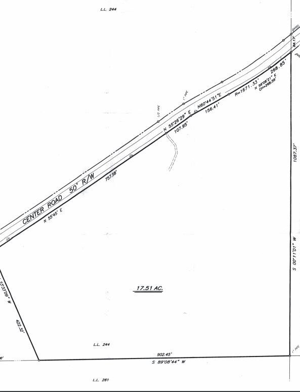
LL 244 D 4 S 6
0078-0244-003
BARTOW
Agriculturalland
Georgia
B and X Area of moderate flood hazard, usually the area between the limits of the 100-year and 500-year floods.
244
2025
15.51 AC
2025
Bartow County
960702
Atlanta
NEARBY LISTINGS FOR SALE OR LEASE
DEMOGRAPHICS near 180 Center Rd Se
1 mile
3 mile
5 mile
2025 Total Population
3,757
26,472
50,618
2030 Population
4,014
28,293
54,099
Pop Growth 2025-2030
+ 6.84%
+ 6.88%
+ 6.88%
Average Age
37
39
40
2025 Total Households
1,331
10,115
19,356
HH Growth 2025-2030
+ 7.06%
+ 6.90%
+ 6.92%
Median Household Inc
$89,374
$77,722
$78,915
Avg Household Size
2.50
2.50
2.50
2025 Avg HH Vehicles
2.00
2.00
2.00
Median Home Value
$326,760
$292,957
$314,795
Median Year Built
2000
1991
1993
Nearby Places
Map Layers
Map Styles
 Street
 Aerial
Layers
 Traffic
 Biking
Places
Listings with unknown addresses are not visible on the map
- Restaurants
- Banks
- Shops
- Fitness
- Groceries
SALE & LEASE HISTORY
LISTING DATE
SALE/LEASE

Oct 14, 2016
For Sale
Oct 08, 2019
For Sale
Nov 11, 2016
For Sale
Jun 05, 2017
For Sale
Jul 20, 2017
For Sale
Nearby Properties
Address
Land Use
TOTAL SIZE
Lot Size
Zoning
Address
Land Use
TOTAL SIZE
Lot Size
Zoning
1,200 SF
25.69 AC
IN
Address
Land Use
TOTAL SIZE
Lot Size
Zoning
141,651 SF
181.89 AC
I1
Address
Land Use
TOTAL SIZE
Lot Size
Zoning
175,810 SF
53.35 AC
Address
Land Use
TOTAL SIZE
Lot Size
Zoning
67,428 SF
36.96 AC
Address
Land Use
TOTAL SIZE
Lot Size
Zoning
127,175 SF
55.52 AC
Address
Land Use
TOTAL SIZE
Lot Size
Zoning
7,488 SF
38.49 AC
IN
Address
Land Use
TOTAL SIZE
Lot Size
Zoning
194,306 SF
126.40 AC
A1
Address
Land Use
TOTAL SIZE
Lot Size
Zoning
90,497 SF
24.36 AC
Address
Land Use
TOTAL SIZE
Lot Size
Zoning
134,528 SF
4.71 AC
IN
Address
Land Use
TOTAL SIZE
Lot Size
Zoning
250,701 SF
15.17 AC
C1
Address
Land Use
TOTAL SIZE
Lot Size
Zoning
342,088 SF
49.67 AC
Address
Land Use
TOTAL SIZE
Lot Size
Zoning
148,808 SF
30.74 AC
A1
Address
Land Use
TOTAL SIZE
Lot Size
Zoning
33,096 SF
15.80 AC
Address
Land Use
TOTAL SIZE
Lot Size
Zoning
51,681 SF
16 AC
Address
Land Use
TOTAL SIZE
Lot Size
Zoning
122,352 SF
26.48 AC
IN
Address
Land Use
TOTAL SIZE
Lot Size
Zoning
313,245 SF
30.15 AC
Address
Land Use
TOTAL SIZE
Lot Size
Zoning
194,368 SF
25.02 AC
IN
Address
Land Use
TOTAL SIZE
Lot Size
Zoning
84,852 SF
6.78 AC
A1
Address
Land Use
TOTAL SIZE
Lot Size
Zoning
91,110 SF
17.09 AC
Address
Land Use
TOTAL SIZE
Lot Size
Zoning
21,465 SF
17.30 AC
IN
Address
Land Use
TOTAL SIZE
Lot Size
Zoning
151,571 SF
25.82 AC
Address
Land Use
TOTAL SIZE
Lot Size
Zoning
24,256 SF
11.87 AC
R3WC
Address
Land Use
TOTAL SIZE
Lot Size
Zoning
13.86 AC
IN
Address
Land Use
TOTAL SIZE
Lot Size
Zoning
88,974 SF
5.42 AC
IN
Address
Land Use
TOTAL SIZE
Lot Size
Zoning
3,696 SF
12 AC
IN
Address
Land Use
TOTAL SIZE
Lot Size
Zoning
211,821 SF
20.32 AC
Address
Land Use
TOTAL SIZE
Lot Size
Zoning
8,064 SF
36.63 AC
IN
Address
Land Use
TOTAL SIZE
Lot Size
Zoning
60,361 SF
13.66 AC
A1
Address
Land Use
TOTAL SIZE
Lot Size
Zoning
123,522 SF
12.52 AC
Address
Land Use
TOTAL SIZE
Lot Size
Zoning
20.79 AC
RESIDENTIA
The World's #1 Commercial Real Estate Marketplace
Connect with us
© 2026 CoStar Group
The information above has been obtained from sources believed reliable. While we do not doubt its accuracy we have not verified it and make no guarantee, warranty or representation about it. It is your responsibility to independently confirm its accuracy and completeness. Any projections, opinions, assumptions, or estimates used are for example only and do not represent the current or future performance of the property. The value of this transaction to you depends on tax and other factors which should be evaluated by your tax, financial, and legal advisors. You and your advisors should conduct a careful, independent investigation of the property to determine to your satisfaction the suitability of the property for your needs.