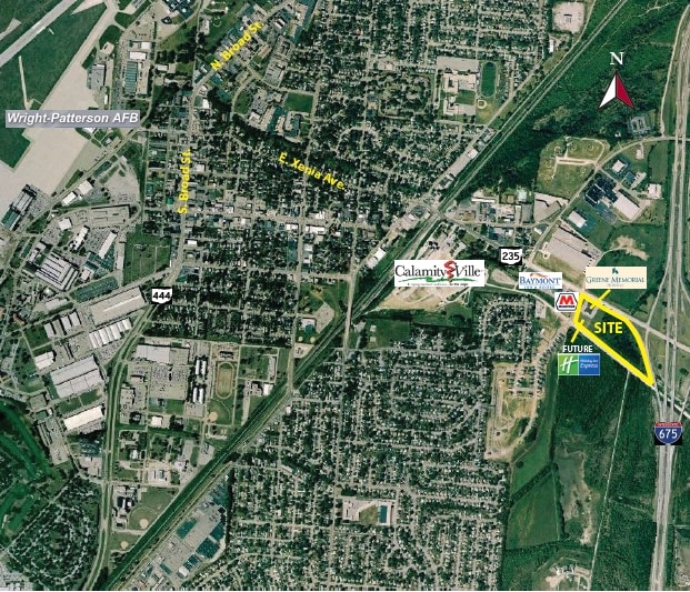
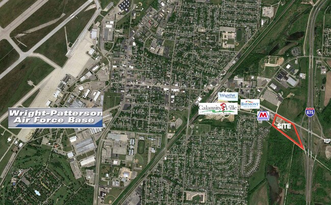
Property Record
Chapelgate Dr, Fairborn, OH 45324

Property Detail
Chapelgate Dr
Dayton, OH
SR 235 & CHAPELGATE DR PLAT LOT 2 2.051AC S OF 235 CHAPELGATE DR
A02-0001-0039-0-0008-00
GREENE
Commercialacreage
Ohio
O1
2
B and X Area of moderate flood hazard, usually the area between the limits of the 100-year and 500-year floods.
2.05 AC
2025
East Dayton
2025
Cincinnati/Dayton
200600
NEARBY LISTINGS FOR SALE OR LEASE
-
-
-
-
-
-
No Photo
-
-
View all Fairborn listings for sale on LoopNet.com
DEMOGRAPHICS near Chapelgate Dr
1 mile
3 mile
5 mile
2025 Total Population
5,671
34,138
64,936
2030 Population
5,825
35,219
66,959
Pop Growth 2025-2030
+ 2.72%
+ 3.17%
+ 3.12%
Average Age
40
40
39
2025 Total Households
2,381
15,164
27,992
HH Growth 2025-2030
+ 2.98%
+ 3.34%
+ 3.30%
Median Household Inc
$65,127
$61,342
$68,732
Avg Household Size
2.30
2.20
2.20
2025 Avg HH Vehicles
2.00
2.00
2.00
Median Home Value
$176,569
$190,058
$220,306
Median Year Built
1957
1967
1977
Nearby Places
Map Layers
Map Styles
 Street
 Aerial
Layers
 Traffic
 Biking
Places
Listings with unknown addresses are not visible on the map
- Restaurants
- Banks
- Shops
- Fitness
- Groceries
PUBLIC TRANSPORTATION
AIRPORT
James M Cox Dayton International
Drive
Walk
Distance
James M Cox Dayton International
27 min
19.9 mi
Freight Ports
Port of Toledo
Drive
Walk
Distance
Port of Toledo
186 min
160.1 mi
SALE & LEASE HISTORY
LISTING DATE
SALE/LEASE

Sep 24, 2016
For Sale
Nearby Properties
Address
Land Use
TOTAL SIZE
Lot Size
Zoning
Address
Land Use
TOTAL SIZE
Lot Size
Zoning
Address
Land Use
TOTAL SIZE
Lot Size
Zoning
101,768 SF
22.02 AC
B1
Address
Land Use
TOTAL SIZE
Lot Size
Zoning
271,232 SF
20.88 AC
PD2
Address
Land Use
TOTAL SIZE
Lot Size
Zoning
50,698 SF
9.43 AC
R2
Address
Land Use
TOTAL SIZE
Lot Size
Zoning
57,816 SF
9.15 AC
PD1
Address
Land Use
TOTAL SIZE
Lot Size
Zoning
17,600 SF
16.43 AC
Address
Land Use
TOTAL SIZE
Lot Size
Zoning
594,070 SF
43.95 AC
AG
Address
Land Use
TOTAL SIZE
Lot Size
Zoning
45,204 SF
14.92 AC
PD1
Address
Land Use
TOTAL SIZE
Lot Size
Zoning
146,569 SF
11.81 AC
Address
Land Use
TOTAL SIZE
Lot Size
Zoning
278,290 SF
18.87 AC
AG
Address
Land Use
TOTAL SIZE
Lot Size
Zoning
46,802 SF
25.30 AC
R3
Address
Land Use
TOTAL SIZE
Lot Size
Zoning
4,494 SF
23.15 AC
R1
Address
Land Use
TOTAL SIZE
Lot Size
Zoning
11.96 AC
AG
Address
Land Use
TOTAL SIZE
Lot Size
Zoning
163,780 SF
36.93 AC
PARK
Address
Land Use
TOTAL SIZE
Lot Size
Zoning
7,772 SF
8.52 AC
R3
Address
Land Use
TOTAL SIZE
Lot Size
Zoning
46,656 SF
10.35 AC
PD1
Address
Land Use
TOTAL SIZE
Lot Size
Zoning
159,880 SF
24.60 AC
I1
Address
Land Use
TOTAL SIZE
Lot Size
Zoning
5.90 AC
IR
Address
Land Use
TOTAL SIZE
Lot Size
Zoning
74,238 SF
6.34 AC
PD-2
Address
Land Use
TOTAL SIZE
Lot Size
Zoning
261,152 SF
15.63 AC
B3
Address
Land Use
TOTAL SIZE
Lot Size
Zoning
46,005 SF
9.33 AC
PD4
Address
Land Use
TOTAL SIZE
Lot Size
Zoning
51,279 SF
2.58 AC
PD1
Address
Land Use
TOTAL SIZE
Lot Size
Zoning
24,512 SF
6.73 AC
PD1
Address
Land Use
TOTAL SIZE
Lot Size
Zoning
24,522 SF
8.46 AC
R3
Address
Land Use
TOTAL SIZE
Lot Size
Zoning
6.43 AC
Address
Land Use
TOTAL SIZE
Lot Size
Zoning
24,512 SF
5.75 AC
PD1
Address
Land Use
TOTAL SIZE
Lot Size
Zoning
38,324 SF
2.77 AC
R4
Address
Land Use
TOTAL SIZE
Lot Size
Zoning
3,456 SF
5.66 AC
PD1
Address
Land Use
TOTAL SIZE
Lot Size
Zoning
31,338 SF
0.25 AC
B2
Address
Land Use
TOTAL SIZE
Lot Size
Zoning
2,556 SF
338.34 AC
The World's #1 Commercial Real Estate Marketplace
Connect with us
© 2026 CoStar Group
The information above has been obtained from sources believed reliable. While we do not doubt its accuracy we have not verified it and make no guarantee, warranty or representation about it. It is your responsibility to independently confirm its accuracy and completeness. Any projections, opinions, assumptions, or estimates used are for example only and do not represent the current or future performance of the property. The value of this transaction to you depends on tax and other factors which should be evaluated by your tax, financial, and legal advisors. You and your advisors should conduct a careful, independent investigation of the property to determine to your satisfaction the suitability of the property for your needs.