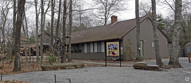
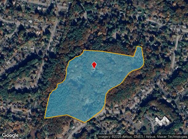
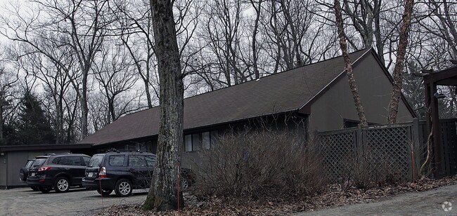
Property Record
180 Hemenway Rd, Framingham, MA 01701
NEARBY LISTINGS FOR SALE OR LEASE
Property Detail
180 Hemenway Rd
FRAM-000017-000059-007362
Middlesex
Charitableorganization
Massachusetts
AE
7362
25017C0508F
1 AC
0
Framingham/Natick
2025
Boston
383904
Boston-Cambridge-Newton, MA-NH
9,050 SF
DEMOGRAPHICS near 180 Hemenway Rd
1 Mile
3 Mile
5 Mile
2024 Total Population
6,037
41,165
126,542
2029 Population
5,978
40,743
125,755
Pop Growth 2024-2029
(0.98%)
(1.03%)
(0.62%)
Average Age
45
43
41
2024 Total Households
2,418
15,460
48,664
HH Growth 2024-2029
(0.99%)
(1.11%)
(0.67%)
Median Household Inc
$116,131
$145,561
$113,067
Avg Household Size
2.40
2.50
2.50
2024 Avg HH Vehicles
2.00
2.00
2.00
Median Home Value
$515,768
$652,773
$659,814
Median Year Built
1963
1964
1968
Nearby Places
Map Layers
Map Styles
 Street
 Aerial
- Restaurants
- Banks
- Shops
- Fitness
- Groceries
PUBLIC TRANSPORTATION
COMMUTER RAIL
Framingham (Framingham/Worcester Line - Massachusetts Bay Transportation Authority Commuter Rail (Purple Line))
DRIVE
WALK
Distance
Framingham (Framingham/Worcester Line - Massachusetts Bay Transportation Authority Commuter Rail (Purple Line))
12 min
5.4 mi
West Natick (Framingham/Worcester Line - Massachusetts Bay Transportation Authority Commuter Rail (Purple Line))
DRIVE
WALK
Distance
West Natick (Framingham/Worcester Line - Massachusetts Bay Transportation Authority Commuter Rail (Purple Line))
16 min
6.7 mi
AIRPORT
General Edward Lawrence Logan International
DRIVE
WALK
Distance
General Edward Lawrence Logan International
42 min
26.4 mi
Worcester Regional
DRIVE
WALK
Distance
Worcester Regional
48 min
26.9 mi
Freight Ports
Port of Boston
DRIVE
WALK
Distance
Port of Boston
40 min
24.7 mi
Nearby Properties
Address
Land Use
TOTAL SIZE
Lot Size
Zoning
Address
Land Use
TOTAL SIZE
Lot Size
Zoning
396,002 SF
44.44 AC
R1
Address
Land Use
TOTAL SIZE
Lot Size
Zoning
24.78 AC
LID
Address
Land Use
TOTAL SIZE
Lot Size
Zoning
837,977 SF
18.57 AC
M1
Address
Land Use
TOTAL SIZE
Lot Size
Zoning
87,102 SF
8.26 AC
R40
Address
Land Use
TOTAL SIZE
Lot Size
Zoning
136,919 SF
13.42 AC
M
Address
Land Use
TOTAL SIZE
Lot Size
Zoning
51,524 SF
67.86 AC
R40
Address
Land Use
TOTAL SIZE
Lot Size
Zoning
182,524 SF
3.60 AC
B2
Address
Land Use
TOTAL SIZE
Lot Size
Zoning
231,897 SF
7.90 AC
B
Address
Land Use
TOTAL SIZE
Lot Size
Zoning
182,736 SF
7.30 AC
B2
Address
Land Use
TOTAL SIZE
Lot Size
Zoning
139,397 SF
9.15 AC
M
Address
Land Use
TOTAL SIZE
Lot Size
Zoning
350,935 SF
25.51 AC
M
Address
Land Use
TOTAL SIZE
Lot Size
Zoning
183,338 SF
4.85 AC
B2
Address
Land Use
TOTAL SIZE
Lot Size
Zoning
114,000 SF
31.53 AC
PRD
Address
Land Use
TOTAL SIZE
Lot Size
Zoning
239,454 SF
12.65 AC
R3
Address
Land Use
TOTAL SIZE
Lot Size
Zoning
134,628 SF
8.26 AC
M1
Address
Land Use
TOTAL SIZE
Lot Size
Zoning
239,614 SF
5.82 AC
M
Address
Land Use
TOTAL SIZE
Lot Size
Zoning
126,828 SF
8.81 AC
R4
Address
Land Use
TOTAL SIZE
Lot Size
Zoning
117,056 SF
10.97 AC
M1
Address
Land Use
TOTAL SIZE
Lot Size
Zoning
162,704 SF
26.50 AC
RESA
Address
Land Use
TOTAL SIZE
Lot Size
Zoning
125,276 SF
10 AC
M1
Address
Land Use
TOTAL SIZE
Lot Size
Zoning
80,180 SF
9.41 AC
M1
Address
Land Use
TOTAL SIZE
Lot Size
Zoning
26.16 AC
LID
Address
Land Use
TOTAL SIZE
Lot Size
Zoning
115,879 SF
0.32 AC
R1
Address
Land Use
TOTAL SIZE
Lot Size
Zoning
27.16 AC
RESA
Address
Land Use
TOTAL SIZE
Lot Size
Zoning
137,512 SF
1.60 AC
R1
Address
Land Use
TOTAL SIZE
Lot Size
Zoning
28.26 AC
LID
Address
Land Use
TOTAL SIZE
Lot Size
Zoning
74,652 SF
6.97 AC
B
Address
Land Use
TOTAL SIZE
Lot Size
Zoning
194,372 SF
35.72 AC
R3
Address
Land Use
TOTAL SIZE
Lot Size
Zoning
75,638 SF
23.51 AC
R3
Address
Land Use
TOTAL SIZE
Lot Size
Zoning
53.75 AC
The World's #1 Commercial Real Estate Marketplace
Connect with us
© 2025 CoStar Group
The information above has been obtained from sources believed reliable. While we do not doubt its accuracy we have not verified it and make no guarantee, warranty or representation about it. It is your responsibility to independently confirm its accuracy and completeness. Any projections, opinions, assumptions, or estimates used are for example only and do not represent the current or future performance of the property. The value of this transaction to you depends on tax and other factors which should be evaluated by your tax, financial, and legal advisors. You and your advisors should conduct a careful, independent investigation of the property to determine to your satisfaction the suitability of the property for your needs.