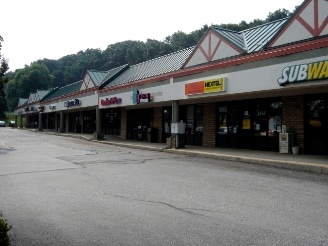
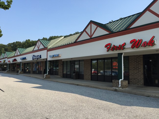
Property Record
180 Leaders Heights Rd, York, PA 17402

NEARBY LISTINGS FOR SALE OR LEASE
Property Detail
180 Leaders Heights Rd
54-000-36-0204.00-00000
Approved Subdivision Plan
Stripcommercialcenter
York
X
Pennsylvania
42133C0337F
4.41 AC
2025
York County
2025
Philadelphia
022801
York-Hanover, PA
27,370 SF
DEMOGRAPHICS near 180 Leaders Heights Rd
1 Mile
3 Mile
5 Mile
2024 Total Population
4,228
34,223
133,398
2029 Population
4,356
35,136
136,801
Pop Growth 2024-2029
+ 3.03%
+ 2.67%
+ 2.55%
Average Age
45
42
39
2024 Total Households
1,732
13,183
51,747
HH Growth 2024-2029
+ 3.18%
+ 2.78%
+ 2.62%
Median Household Inc
$94,452
$83,980
$61,838
Avg Household Size
2.40
2.40
2.40
2024 Avg HH Vehicles
2.00
2.00
2.00
Median Home Value
$218,277
$234,721
$192,523
Median Year Built
1976
1973
1961
Nearby Places
Map Layers
Map Styles
 Street
 Aerial
- Restaurants
- Banks
- Shops
- Fitness
- Groceries
PUBLIC TRANSPORTATION
AIRPORT
Harrisburg International
DRIVE
WALK
Distance
Harrisburg International
39 min
36.6 mi
Freight Ports
Port of Baltimore
DRIVE
WALK
Distance
Port of Baltimore
1 min
44.9 mi
SALE & LEASE HISTORY
LISTING DATE
SALE/LEASE

Sep 25, 2016
For Lease
Mar 29, 2017
For Lease
Nearby Properties
Address
Land Use
TOTAL SIZE
Lot Size
Zoning
Address
Land Use
TOTAL SIZE
Lot Size
Zoning
2,320 SF
25.89 AC
RS
Address
Land Use
TOTAL SIZE
Lot Size
Zoning
1,881 SF
21.82 AC
RS
Address
Land Use
TOTAL SIZE
Lot Size
Zoning
286,411 SF
35.12 AC
CM
Address
Land Use
TOTAL SIZE
Lot Size
Zoning
11.83 AC
RS
Address
Land Use
TOTAL SIZE
Lot Size
Zoning
195,669 SF
22.25 AC
RS
Address
Land Use
TOTAL SIZE
Lot Size
Zoning
21,840 SF
19.91 AC
RS
Address
Land Use
TOTAL SIZE
Lot Size
Zoning
35,096 SF
12.77 AC
OP
Address
Land Use
TOTAL SIZE
Lot Size
Zoning
53,226 SF
18.19 AC
ID
Address
Land Use
TOTAL SIZE
Lot Size
Zoning
43,674 SF
4.63 AC
CM
Address
Land Use
TOTAL SIZE
Lot Size
Zoning
25,608 SF
10.34 AC
RS
Address
Land Use
TOTAL SIZE
Lot Size
Zoning
1,404 SF
4.49 AC
AG
Address
Land Use
TOTAL SIZE
Lot Size
Zoning
45,388 SF
38.35 AC
ID
Address
Land Use
TOTAL SIZE
Lot Size
Zoning
18.21 AC
RS
Address
Land Use
TOTAL SIZE
Lot Size
Zoning
1,800 SF
236 AC
OS
Address
Land Use
TOTAL SIZE
Lot Size
Zoning
18,382 SF
11.72 AC
RS
Address
Land Use
TOTAL SIZE
Lot Size
Zoning
28,914 SF
2.38 AC
CM
Address
Land Use
TOTAL SIZE
Lot Size
Zoning
48,984 SF
6.82 AC
OP
Address
Land Use
TOTAL SIZE
Lot Size
Zoning
26,344 SF
3.63 AC
CM
Address
Land Use
TOTAL SIZE
Lot Size
Zoning
46,910 SF
2.26 AC
Address
Land Use
TOTAL SIZE
Lot Size
Zoning
35,996 SF
4.29 AC
RH9
Address
Land Use
TOTAL SIZE
Lot Size
Zoning
27,638 SF
7.31 AC
CM
Address
Land Use
TOTAL SIZE
Lot Size
Zoning
0.77 AC
Address
Land Use
TOTAL SIZE
Lot Size
Zoning
65,574 SF
0.74 AC
Address
Land Use
TOTAL SIZE
Lot Size
Zoning
12.80 AC
RS
Address
Land Use
TOTAL SIZE
Lot Size
Zoning
31,212 SF
2.31 AC
CM
Address
Land Use
TOTAL SIZE
Lot Size
Zoning
1,536 SF
6.89 AC
RS
Address
Land Use
TOTAL SIZE
Lot Size
Zoning
0.29 AC
Address
Land Use
TOTAL SIZE
Lot Size
Zoning
0.25 AC
Address
Land Use
TOTAL SIZE
Lot Size
Zoning
1,792 SF
54.42 AC
OP
Address
Land Use
TOTAL SIZE
Lot Size
Zoning
53,594 SF
4.27 AC
CS
The World's #1 Commercial Real Estate Marketplace
Connect with us
© 2026 CoStar Group
The information above has been obtained from sources believed reliable. While we do not doubt its accuracy we have not verified it and make no guarantee, warranty or representation about it. It is your responsibility to independently confirm its accuracy and completeness. Any projections, opinions, assumptions, or estimates used are for example only and do not represent the current or future performance of the property. The value of this transaction to you depends on tax and other factors which should be evaluated by your tax, financial, and legal advisors. You and your advisors should conduct a careful, independent investigation of the property to determine to your satisfaction the suitability of the property for your needs.