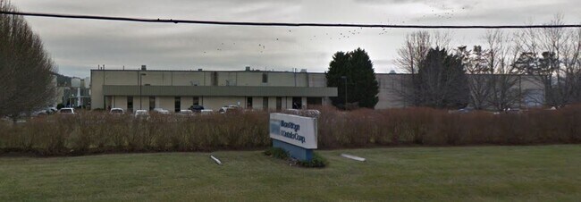
Property Record
180 Mills Gap Rd, Fletcher, NC 28732

Save to a Folder
{{folder.Name}}
{{folder.ListingIds.length}} Properties
{{folder.ListingIds.length}} Property
Create a New Folder
Property Detail
180 Mills Gap Rd
9663202243
SUBDIVISION 22.31 ACRES TRI PL2021-13580
Industrialgeneral
Henderson
10007851~M
North Carolina
B and X Area of moderate flood hazard, usually the area between the limits of the 100-year and 500-year floods.
2243
2025
22.31 AC
2026
Henderson County
930502
Asheville
177,124 SF
Asheville, NC
NEARBY LISTINGS FOR SALE OR LEASE
DEMOGRAPHICS near 180 Mills Gap Rd
1 mile
3 mile
5 mile
2025 Total Population
1,841
21,771
50,029
2030 Population
1,930
22,326
51,332
Pop Growth 2025-2030
+ 4.83%
+ 2.55%
+ 2.60%
Average Age
41
42
43
2025 Total Households
780
9,023
20,887
HH Growth 2025-2030
+ 5.00%
+ 2.58%
+ 2.56%
Median Household Inc
$63,951
$75,225
$75,779
Avg Household Size
2.30
2.40
2.30
2025 Avg HH Vehicles
2.00
2.00
2.00
Median Home Value
$358,571
$365,835
$394,880
Median Year Built
2005
1995
1993
Nearby Places
Map Layers
Map Styles
 Street
 Aerial
Layers
 Traffic
 Biking
Places
Listings with unknown addresses are not visible on the map
- Restaurants
- Banks
- Shops
- Fitness
- Groceries
PUBLIC TRANSPORTATION
AIRPORT
Asheville Regional
Drive
Walk
Distance
Asheville Regional
10 min
5.2 mi
Nearby Properties
Address
Land Use
TOTAL SIZE
Lot Size
Zoning
Address
Land Use
TOTAL SIZE
Lot Size
Zoning
226,140 SF
25.47 AC
9971974~OI
Address
Land Use
TOTAL SIZE
Lot Size
Zoning
85,103 SF
11.69 AC
RES EXP
Address
Land Use
TOTAL SIZE
Lot Size
Zoning
207,701 SF
458.72 AC
R-3
Address
Land Use
TOTAL SIZE
Lot Size
Zoning
481,731 SF
86.32 AC
1009658~I
Address
Land Use
TOTAL SIZE
Lot Size
Zoning
4,839 SF
9.46 AC
10002512~C
Address
Land Use
TOTAL SIZE
Lot Size
Zoning
3,466 SF
11.32 AC
10000832~M
Address
Land Use
TOTAL SIZE
Lot Size
Zoning
92,772 SF
12.30 AC
R-2
Address
Land Use
TOTAL SIZE
Lot Size
Zoning
899,676 SF
46.99 AC
1006235~M-
Address
Land Use
TOTAL SIZE
Lot Size
Zoning
43,882 SF
9.71 AC
1016337~C1
Address
Land Use
TOTAL SIZE
Lot Size
Zoning
24.29 AC
1012291~M-
Address
Land Use
TOTAL SIZE
Lot Size
Zoning
87,220 SF
39.11 AC
PS
Address
Land Use
TOTAL SIZE
Lot Size
Zoning
107,698 SF
25.53 AC
PS
Address
Land Use
TOTAL SIZE
Lot Size
Zoning
208,715 SF
33.50 AC
CI
Address
Land Use
TOTAL SIZE
Lot Size
Zoning
41,104 SF
5.45 AC
CR
Address
Land Use
TOTAL SIZE
Lot Size
Zoning
76,255 SF
10.55 AC
EMP
Address
Land Use
TOTAL SIZE
Lot Size
Zoning
415,861 SF
59.02 AC
9927651~M-
Address
Land Use
TOTAL SIZE
Lot Size
Zoning
13,525 SF
1.84 AC
LODG EXP
Address
Land Use
TOTAL SIZE
Lot Size
Zoning
15,493 SF
2.01 AC
EMP
Address
Land Use
TOTAL SIZE
Lot Size
Zoning
28,183 SF
5.88 AC
10010086~C
Address
Land Use
TOTAL SIZE
Lot Size
Zoning
82,096 SF
19.67 AC
1015839~R1
Address
Land Use
TOTAL SIZE
Lot Size
Zoning
51,090 SF
5.18 AC
1007612~C-
Address
Land Use
TOTAL SIZE
Lot Size
Zoning
1,575 SF
18.75 AC
10002245~C
Address
Land Use
TOTAL SIZE
Lot Size
Zoning
43,030 SF
5.15 AC
1016338~C1
Address
Land Use
TOTAL SIZE
Lot Size
Zoning
71,973 SF
6.71 AC
HB
Address
Land Use
TOTAL SIZE
Lot Size
Zoning
8,426 SF
9.31 AC
10011303~R
Address
Land Use
TOTAL SIZE
Lot Size
Zoning
404,414 SF
27.75 AC
IND
Address
Land Use
TOTAL SIZE
Lot Size
Zoning
57,827 SF
1.68 AC
1017417~C-
Address
Land Use
TOTAL SIZE
Lot Size
Zoning
22,722 SF
4.73 AC
10011342~O
Address
Land Use
TOTAL SIZE
Lot Size
Zoning
39,080 SF
70.04 AC
1001876~R1
Address
Land Use
TOTAL SIZE
Lot Size
Zoning
56,273 SF
2.43 AC
1000215~C-
The World's #1 Commercial Real Estate Marketplace
Connect with us
© 2026 CoStar Group
The information above has been obtained from sources believed reliable. While we do not doubt its accuracy we have not verified it and make no guarantee, warranty or representation about it. It is your responsibility to independently confirm its accuracy and completeness. Any projections, opinions, assumptions, or estimates used are for example only and do not represent the current or future performance of the property. The value of this transaction to you depends on tax and other factors which should be evaluated by your tax, financial, and legal advisors. You and your advisors should conduct a careful, independent investigation of the property to determine to your satisfaction the suitability of the property for your needs.