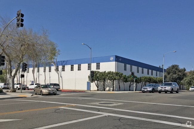
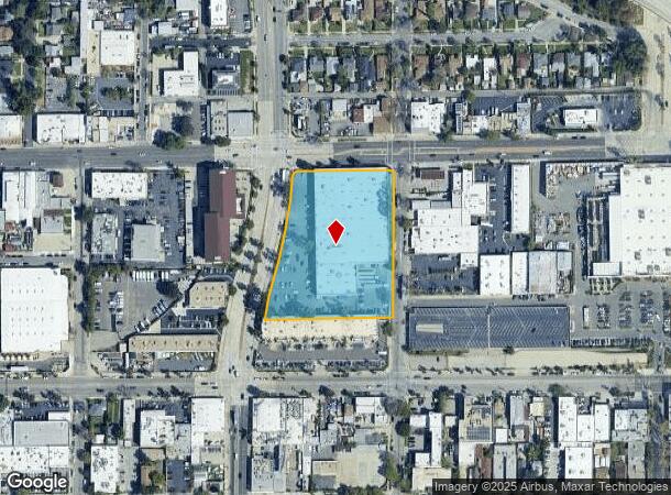
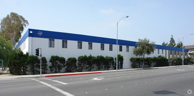
Property Record
180 N San Gabriel Blvd, Pasadena, CA 91107

NEARBY LISTINGS FOR SALE OR LEASE
Property Detail
180 N San Gabriel Blvd
Los Angeles-Long Beach-Glendale, CA
No 1 Map Of The Lamanda Park Addition
5748-002-030
*TR=PARCEL MAP AS PER BK 109 P 11-12 OF PM LOT 1
Lightindustrial
Los Angeles
X
California
06037C1400F
1
2024
3.31 AC
2025
Upper San Gabriel Valley
462900
Los Angeles
125,280 SF
DEMOGRAPHICS near 180 N San Gabriel Blvd
1 Mile
3 Mile
5 Mile
2024 Total Population
17,864
167,801
432,755
2029 Population
17,290
163,010
419,482
Pop Growth 2024-2029
(3.21%)
(2.86%)
(3.07%)
Average Age
42
43
42
2024 Total Households
7,395
66,328
160,613
HH Growth 2024-2029
(3.39%)
(3.05%)
(3.27%)
Median Household Inc
$103,264
$98,373
$95,904
Avg Household Size
2.30
2.40
2.60
2024 Avg HH Vehicles
2.00
2.00
2.00
Median Home Value
$917,649
$1,007,274
$966,513
Median Year Built
1953
1957
1957
Nearby Places
Map Layers
Map Styles
 Street
 Aerial
- Restaurants
- Banks
- Shops
- Fitness
- Groceries
PUBLIC TRANSPORTATION
TRANSIT/SUBWAY
Sierra Madre Villa Station (Gold Line - Los Angeles County Metropolitan Transportation Authority (Metro))
DRIVE
WALK
Distance
Sierra Madre Villa Station (Gold Line - Los Angeles County Metropolitan Transportation Authority (Metro))
3 min
15 min
0.8 mi
COMMUTER RAIL
El Monte (San Bernardino Line - Southern California Regional Rail Authority (Metrolink))
DRIVE
WALK
Distance
El Monte (San Bernardino Line - Southern California Regional Rail Authority (Metrolink))
16 min
7.8 mi
AIRPORT
Bob Hope
DRIVE
WALK
Distance
Bob Hope
27 min
20.0 mi
Long Beach (Daugherty Field)
DRIVE
WALK
Distance
Long Beach (Daugherty Field)
44 min
28.2 mi
Los Angeles International
DRIVE
WALK
Distance
Los Angeles International
45 min
28.6 mi
Nearby Properties
Address
Land Use
TOTAL SIZE
Lot Size
Zoning
Address
Land Use
TOTAL SIZE
Lot Size
Zoning
945,101 SF
38.07 AC
ARC2DH-S1-
Address
Land Use
TOTAL SIZE
Lot Size
Zoning
327,804 SF
17.76 AC
PSR*
Address
Land Use
TOTAL SIZE
Lot Size
Zoning
346,537 SF
3.33 AC
PSC-
Address
Land Use
TOTAL SIZE
Lot Size
Zoning
262,988 SF
1.42 AC
PSR*
Address
Land Use
TOTAL SIZE
Lot Size
Zoning
91,229 SF
206.59 AC
SOH
Address
Land Use
TOTAL SIZE
Lot Size
Zoning
278,741 SF
1.21 AC
PSC*
Address
Land Use
TOTAL SIZE
Lot Size
Zoning
291,667 SF
0.83 AC
PSC-
Address
Land Use
TOTAL SIZE
Lot Size
Zoning
255,411 SF
0.81 AC
PSC-
Address
Land Use
TOTAL SIZE
Lot Size
Zoning
231,187 SF
1.47 AC
PSC-
Address
Land Use
TOTAL SIZE
Lot Size
Zoning
192,792 SF
14.52 AC
PSR
Address
Land Use
TOTAL SIZE
Lot Size
Zoning
749,874 SF
4.74 AC
PSC-
Address
Land Use
TOTAL SIZE
Lot Size
Zoning
230,045 SF
3.20 AC
PSC*
Address
Land Use
TOTAL SIZE
Lot Size
Zoning
255,343 SF
0.80 AC
PSC-
Address
Land Use
TOTAL SIZE
Lot Size
Zoning
266,947 SF
10.91 AC
PSC2
Address
Land Use
TOTAL SIZE
Lot Size
Zoning
220,402 SF
1.35 AC
PSC-
Address
Land Use
TOTAL SIZE
Lot Size
Zoning
203,067 SF
0.62 AC
PSC-
Address
Land Use
TOTAL SIZE
Lot Size
Zoning
452,713 SF
28.21 AC
PSC*
Address
Land Use
TOTAL SIZE
Lot Size
Zoning
531,606 SF
8.20 AC
PSC*
Address
Land Use
TOTAL SIZE
Lot Size
Zoning
299,385 SF
4.37 AC
PSC*
Address
Land Use
TOTAL SIZE
Lot Size
Zoning
383,924 SF
2.10 AC
PSC-
Address
Land Use
TOTAL SIZE
Lot Size
Zoning
237,930 SF
2.98 AC
PSC*
Address
Land Use
TOTAL SIZE
Lot Size
Zoning
217,778 SF
1.81 AC
PSC-
Address
Land Use
TOTAL SIZE
Lot Size
Zoning
161,825 SF
4.04 AC
PSC*
Address
Land Use
TOTAL SIZE
Lot Size
Zoning
225,995 SF
10.86 AC
PSC2*
Address
Land Use
TOTAL SIZE
Lot Size
Zoning
158,307 SF
2.23 AC
PSC-
Address
Land Use
TOTAL SIZE
Lot Size
Zoning
210,083 SF
9.61 AC
PSMG
Address
Land Use
TOTAL SIZE
Lot Size
Zoning
133,502 SF
1.18 AC
PSC
Address
Land Use
TOTAL SIZE
Lot Size
Zoning
148,214 SF
1.33 AC
PSC-
Address
Land Use
TOTAL SIZE
Lot Size
Zoning
250,257 SF
2.43 AC
PSC-
The World's #1 Commercial Real Estate Marketplace
Connect with us
© 2025 CoStar Group
The information above has been obtained from sources believed reliable. While we do not doubt its accuracy we have not verified it and make no guarantee, warranty or representation about it. It is your responsibility to independently confirm its accuracy and completeness. Any projections, opinions, assumptions, or estimates used are for example only and do not represent the current or future performance of the property. The value of this transaction to you depends on tax and other factors which should be evaluated by your tax, financial, and legal advisors. You and your advisors should conduct a careful, independent investigation of the property to determine to your satisfaction the suitability of the property for your needs.