Property Record
180 Napoleon St, San Francisco, CA 94124


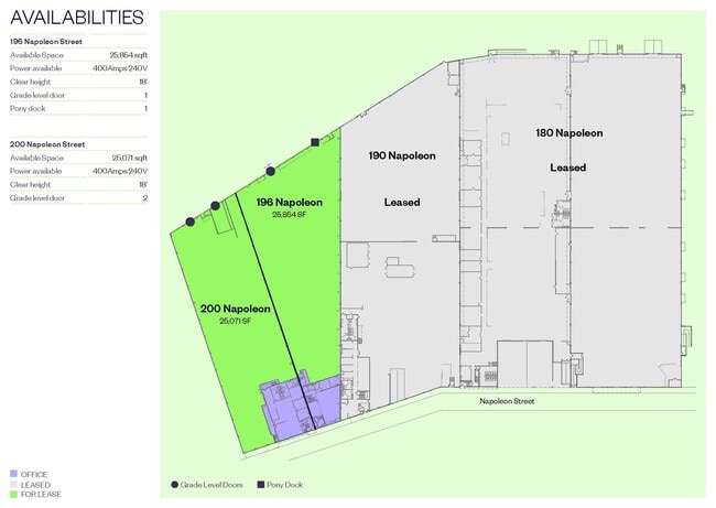

Current Lease Availabilities
NEARBY LISTINGS FOR SALE OR LEASE
Property Detail
180 Napoleon St
San Francisco-Redwood City-South San Francisco, CA
San Francisco
4343-004
California
Industrialgeneral
4
2024
4.94 AC
2025
Mission/Potrero
980900
San Francisco
28,300 SF
DEMOGRAPHICS near 180 Napoleon St
1 Mile
3 Mile
5 Mile
2024 Total Population
40,072
398,687
744,335
2029 Population
37,215
369,387
688,742
Pop Growth 2024-2029
(7.13%)
(7.35%)
(7.47%)
Average Age
40
42
42
2024 Total Households
14,599
169,414
315,619
HH Growth 2024-2029
(7.61%)
(7.68%)
(7.80%)
Median Household Inc
$149,495
$122,832
$126,697
Avg Household Size
2.50
2.20
2.20
2024 Avg HH Vehicles
1.00
1.00
1.00
Median Home Value
$1,087,500
$1,083,941
$1,092,165
Median Year Built
1948
1956
1949
Nearby Places
Map Layers
Map Styles
 Street
 Aerial
- Restaurants
- Banks
- Shops
- Fitness
- Groceries
PUBLIC TRANSPORTATION
TRANSIT/SUBWAY
Evans Avenue Station Outbound (T Third Street - San Francisco Municipal Railway (MUNI Metro))
DRIVE
WALK
Distance
Evans Avenue Station Outbound (T Third Street - San Francisco Municipal Railway (MUNI Metro))
2 min
14 min
0.7 mi
Hudson/Innes Station (T Third Street - San Francisco Municipal Railway (MUNI Metro), THIRD - San Francisco Municipal Railway (MUNI Metro))
DRIVE
WALK
Distance
Hudson/Innes Station (T Third Street - San Francisco Municipal Railway (MUNI Metro), THIRD - San Francisco Municipal Railway (MUNI Metro))
2 min
16 min
0.9 mi
Third Street & Marin St (THIRD - San Francisco Municipal Transportation Agency)
DRIVE
WALK
Distance
Third Street & Marin St (THIRD - San Francisco Municipal Transportation Agency)
2 min
18 min
0.9 mi
Marin Street Station (T Third Street - San Francisco Municipal Railway (MUNI Metro))
DRIVE
WALK
Distance
Marin Street Station (T Third Street - San Francisco Municipal Railway (MUNI Metro))
3 min
18 min
1.0 mi
COMMUTER RAIL
22Nd Street Caltrain Station Southbound (Express - Caltrain (Caltrain), Limited - Caltrain (Caltrain), Local Weekday - Caltrain (Caltrain), Local Weekend - Caltrain (Caltrain))
DRIVE
WALK
Distance
22Nd Street Caltrain Station Southbound (Express - Caltrain (Caltrain), Limited - Caltrain (Caltrain), Local Weekday - Caltrain (Caltrain), Local Weekend - Caltrain (Caltrain))
4 min
2.1 mi
22Nd Street (Caltrain - Caltrain (Caltrain))
DRIVE
WALK
Distance
22Nd Street (Caltrain - Caltrain (Caltrain))
4 min
2.1 mi
AIRPORT
San Francisco International
DRIVE
WALK
Distance
San Francisco International
19 min
11.9 mi
Metro Oakland International
DRIVE
WALK
Distance
Metro Oakland International
32 min
21.5 mi
Freight Ports
Port of San Francisco
DRIVE
WALK
Distance
Port of San Francisco
9 min
4.5 mi
Nearby Properties
Address
Land Use
TOTAL SIZE
Lot Size
Zoning
Address
Land Use
TOTAL SIZE
Lot Size
Zoning
1,015,000 SF
2.43 AC
RC4
Address
Land Use
TOTAL SIZE
Lot Size
Zoning
764,661 SF
0.67 AC
C3OSD
Address
Land Use
TOTAL SIZE
Lot Size
Zoning
750,370 SF
3.25 AC
MBR3
Address
Land Use
TOTAL SIZE
Lot Size
Zoning
1,420,430 SF
1.16 AC
C3OSD
Address
Land Use
TOTAL SIZE
Lot Size
Zoning
914,037 SF
1.36 AC
C3O
Address
Land Use
TOTAL SIZE
Lot Size
Zoning
248,303 SF
4.35 AC
Address
Land Use
TOTAL SIZE
Lot Size
Zoning
717,234 SF
3.47 AC
UMU
Address
Land Use
TOTAL SIZE
Lot Size
Zoning
475,791 SF
0.55 AC
C3OSD
Address
Land Use
TOTAL SIZE
Lot Size
Zoning
690,442 SF
0.79 AC
C3O
Address
Land Use
TOTAL SIZE
Lot Size
Zoning
10.92 AC
Address
Land Use
TOTAL SIZE
Lot Size
Zoning
750,491 SF
0.51 AC
C3O
Address
Land Use
TOTAL SIZE
Lot Size
Zoning
432,000 SF
0.35 AC
C3OSD
Address
Land Use
TOTAL SIZE
Lot Size
Zoning
266,143 SF
4 AC
C-3-R
Address
Land Use
TOTAL SIZE
Lot Size
Zoning
885,581 SF
5.20 AC
M2
Address
Land Use
TOTAL SIZE
Lot Size
Zoning
508,714 SF
1.29 AC
C3R
Address
Land Use
TOTAL SIZE
Lot Size
Zoning
505,120 SF
0.41 AC
C3O
Address
Land Use
TOTAL SIZE
Lot Size
Zoning
696,431 SF
0.97 AC
C3G
Address
Land Use
TOTAL SIZE
Lot Size
Zoning
139,070 SF
0.64 AC
C3O
Address
Land Use
TOTAL SIZE
Lot Size
Zoning
1.52 AC
C3G
Address
Land Use
TOTAL SIZE
Lot Size
Zoning
1,424,230 SF
2.60 AC
C3G
Address
Land Use
TOTAL SIZE
Lot Size
Zoning
614,740 SF
1.74 AC
C3OSD
Address
Land Use
TOTAL SIZE
Lot Size
Zoning
492,980 SF
0.43 AC
C3O
Address
Land Use
TOTAL SIZE
Lot Size
Zoning
370,694 SF
0.87 AC
RH DTR
Address
Land Use
TOTAL SIZE
Lot Size
Zoning
263,640 SF
0.72 AC
C3R
Address
Land Use
TOTAL SIZE
Lot Size
Zoning
519,235 SF
0.74 AC
C3O
Address
Land Use
TOTAL SIZE
Lot Size
Zoning
434,078 SF
1.08 AC
C3OSD
Address
Land Use
TOTAL SIZE
Lot Size
Zoning
2.74 AC
Address
Land Use
TOTAL SIZE
Lot Size
Zoning
313,306 SF
1.23 AC
WMUG
Address
Land Use
TOTAL SIZE
Lot Size
Zoning
307,000 SF
0.87 AC
C3OSD
Address
Land Use
TOTAL SIZE
Lot Size
Zoning
314,826 SF
1.85 AC
MB-RA
The World's #1 Commercial Real Estate Marketplace
Connect with us
© 2025 CoStar Group
The information above has been obtained from sources believed reliable. While we do not doubt its accuracy we have not verified it and make no guarantee, warranty or representation about it. It is your responsibility to independently confirm its accuracy and completeness. Any projections, opinions, assumptions, or estimates used are for example only and do not represent the current or future performance of the property. The value of this transaction to you depends on tax and other factors which should be evaluated by your tax, financial, and legal advisors. You and your advisors should conduct a careful, independent investigation of the property to determine to your satisfaction the suitability of the property for your needs.