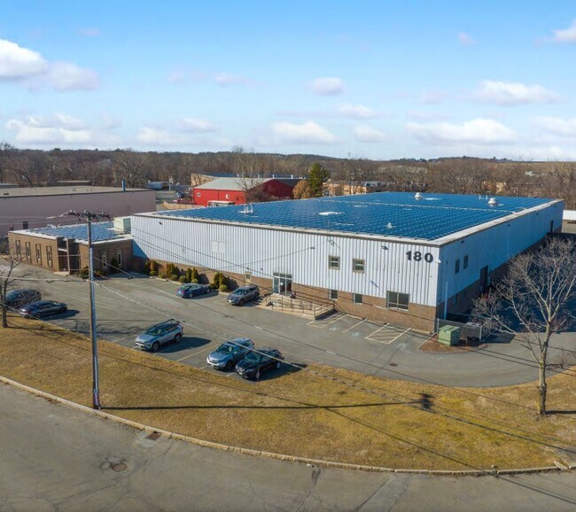
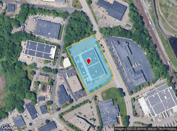
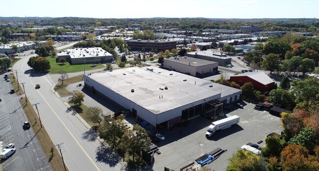
Property Record
1 6Th Rd, Woburn, MA 01801

NEARBY LISTINGS FOR SALE OR LEASE
Property Detail
1 6Th Rd
WOBU-000014-000008-000001
Middlesex
Warehouse
Massachusetts
X
1
25017C0294F
3.69 AC
2025
Wilmington/Winchester
2025
Boston
333502
Boston-Cambridge-Newton, MA-NH
64,175 SF
DEMOGRAPHICS near 1 6Th Rd
1 Mile
3 Mile
5 Mile
2024 Total Population
6,368
82,858
201,156
2029 Population
6,495
82,333
199,283
Pop Growth 2024-2029
+ 1.99%
(0.63%)
(0.93%)
Average Age
39
42
42
2024 Total Households
2,576
32,593
76,743
HH Growth 2024-2029
+ 2.29%
(0.68%)
(1.01%)
Median Household Inc
$117,577
$114,439
$125,322
Avg Household Size
2.40
2.50
2.60
2024 Avg HH Vehicles
2.00
2.00
2.00
Median Home Value
$647,702
$682,915
$710,942
Median Year Built
1987
1967
1965
Nearby Places
Map Layers
Map Styles
 Street
 Aerial
- Restaurants
- Banks
- Shops
- Fitness
- Groceries
PUBLIC TRANSPORTATION
COMMUTER RAIL
Anderson/Woburn Regional Transportation Center (Lowell Line - Massachusetts Bay Transportation Authority Commuter Rail (Purple Line))
DRIVE
WALK
Distance
Anderson/Woburn Regional Transportation Center (Lowell Line - Massachusetts Bay Transportation Authority Commuter Rail (Purple Line))
8 min
2.8 mi
Reading (Haverhill Line - Massachusetts Bay Transportation Authority Commuter Rail (Purple Line))
DRIVE
WALK
Distance
Reading (Haverhill Line - Massachusetts Bay Transportation Authority Commuter Rail (Purple Line))
8 min
3.3 mi
AIRPORT
General Edward Lawrence Logan International
DRIVE
WALK
Distance
General Edward Lawrence Logan International
26 min
15.6 mi
Manchester Boston Regional
DRIVE
WALK
Distance
Manchester Boston Regional
59 min
40.8 mi
Freight Ports
Port of Boston
DRIVE
WALK
Distance
Port of Boston
27 min
15.4 mi
SALE & LEASE HISTORY
LISTING DATE
SALE/LEASE

Sep 25, 2016
For Lease
Sep 20, 2021
For Lease
Oct 24, 2019
For Lease
Mar 01, 2023
For Lease
Aug 08, 2023
For Lease
Aug 07, 2023
For Sale
Nearby Properties
Address
Land Use
TOTAL SIZE
Lot Size
Zoning
Address
Land Use
TOTAL SIZE
Lot Size
Zoning
42.20 AC
S-2
Address
Land Use
TOTAL SIZE
Lot Size
Zoning
388,978 SF
23.23 AC
RG
Address
Land Use
TOTAL SIZE
Lot Size
Zoning
27.56 AC
R-2
Address
Land Use
TOTAL SIZE
Lot Size
Zoning
476,332 SF
5.37 AC
Address
Land Use
TOTAL SIZE
Lot Size
Zoning
405,606 SF
33.40 AC
RO
Address
Land Use
TOTAL SIZE
Lot Size
Zoning
18.62 AC
O-P
Address
Land Use
TOTAL SIZE
Lot Size
Zoning
346,106 SF
42.04 AC
RO
Address
Land Use
TOTAL SIZE
Lot Size
Zoning
330,500 SF
7.44 AC
PD
Address
Land Use
TOTAL SIZE
Lot Size
Zoning
411,956 SF
23.94 AC
S20
Address
Land Use
TOTAL SIZE
Lot Size
Zoning
30.92 AC
RO
Address
Land Use
TOTAL SIZE
Lot Size
Zoning
186,516 SF
40 AC
R-1
Address
Land Use
TOTAL SIZE
Lot Size
Zoning
31.56 AC
HB
Address
Land Use
TOTAL SIZE
Lot Size
Zoning
7.90 AC
PD
Address
Land Use
TOTAL SIZE
Lot Size
Zoning
14.82 AC
RO
Address
Land Use
TOTAL SIZE
Lot Size
Zoning
9.01 AC
S-I
Address
Land Use
TOTAL SIZE
Lot Size
Zoning
341,593 SF
3.38 AC
I-P2
Address
Land Use
TOTAL SIZE
Lot Size
Zoning
129,028 SF
7.17 AC
I-P2
Address
Land Use
TOTAL SIZE
Lot Size
Zoning
153,906 SF
4 AC
S15
Address
Land Use
TOTAL SIZE
Lot Size
Zoning
127.30 AC
R-1
Address
Land Use
TOTAL SIZE
Lot Size
Zoning
27.90 AC
I-P2
Address
Land Use
TOTAL SIZE
Lot Size
Zoning
398,140 SF
39.50 AC
GI
Address
Land Use
TOTAL SIZE
Lot Size
Zoning
17.65 AC
B-I
Address
Land Use
TOTAL SIZE
Lot Size
Zoning
10.73 AC
I-P2
Address
Land Use
TOTAL SIZE
Lot Size
Zoning
19.66 AC
BG
Address
Land Use
TOTAL SIZE
Lot Size
Zoning
5.63 AC
C
Address
Land Use
TOTAL SIZE
Lot Size
Zoning
8.17 AC
RB
Address
Land Use
TOTAL SIZE
Lot Size
Zoning
6.28 AC
RB
Address
Land Use
TOTAL SIZE
Lot Size
Zoning
216,337 SF
7.19 AC
S20
Address
Land Use
TOTAL SIZE
Lot Size
Zoning
141,968 SF
11.28 AC
R20
Address
Land Use
TOTAL SIZE
Lot Size
Zoning
6.77 AC
I-P2
The World's #1 Commercial Real Estate Marketplace
Connect with us
© 2025 CoStar Group
The information above has been obtained from sources believed reliable. While we do not doubt its accuracy we have not verified it and make no guarantee, warranty or representation about it. It is your responsibility to independently confirm its accuracy and completeness. Any projections, opinions, assumptions, or estimates used are for example only and do not represent the current or future performance of the property. The value of this transaction to you depends on tax and other factors which should be evaluated by your tax, financial, and legal advisors. You and your advisors should conduct a careful, independent investigation of the property to determine to your satisfaction the suitability of the property for your needs.