Property Record
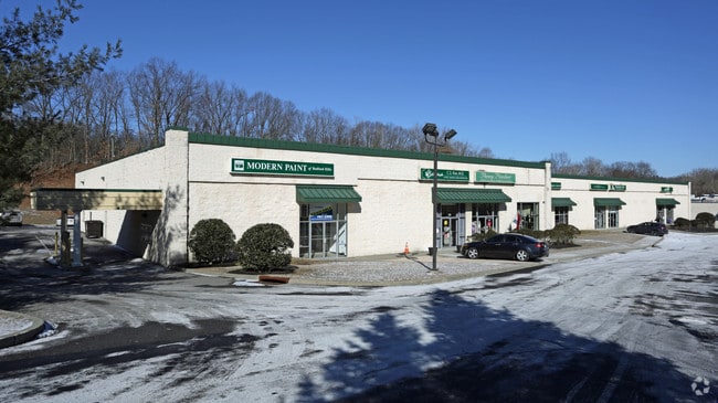
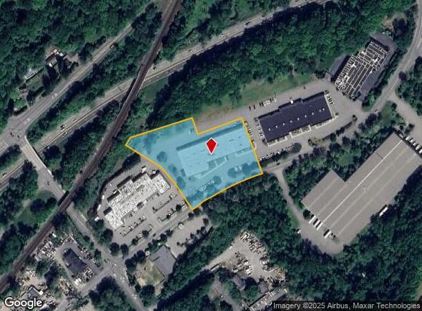
180 Route 117 By Pass Rd, Bedford Hills, NY 10507
NEARBY LISTINGS FOR SALE OR LEASE
Property Detail
180 Route 117 By Pass Rd
New York-Jersey City-White Plains, NY-NJ
Subdivision Map By Pass Development Corp
2000-060-011-00002-000-0010-3
Westchester
Stripcommercialcenter
New York
X
10.003
36119C0156F
3 AC
2025
North
2024
Westchester/So Connecticut
012804
DEMOGRAPHICS near 180 Route 117 By Pass Rd
1 Mile
3 Mile
5 Mile
2024 Total Population
6,065
14,501
41,447
2029 Population
5,992
14,320
40,623
Pop Growth 2024-2029
(1.20%)
(1.25%)
(1.99%)
Average Age
40
41
42
2024 Total Households
1,819
4,815
14,229
HH Growth 2024-2029
(1.43%)
(1.43%)
(2.19%)
Median Household Inc
$99,205
$138,845
$145,110
Avg Household Size
2.70
2.70
2.80
2024 Avg HH Vehicles
2.00
2.00
2.00
Median Home Value
$684,058
$757,633
$746,200
Median Year Built
1963
1966
1967
Nearby Places
- Restaurants
- Banks
- Shops
- Fitness
- Groceries
PUBLIC TRANSPORTATION
COMMUTER RAIL
Bedford Hills Station (Harlem Line - Metro-North Commuter Railroad Company (Metro-North))
DRIVE
WALK
Distance
Bedford Hills Station (Harlem Line - Metro-North Commuter Railroad Company (Metro-North))
2 min
19 min
1.0 mi
Katonah Station (Harlem Line - Metro-North Commuter Railroad Company (Metro-North))
DRIVE
WALK
Distance
Katonah Station (Harlem Line - Metro-North Commuter Railroad Company (Metro-North))
3 min
1.4 mi
AIRPORT
Westchester County
DRIVE
WALK
Distance
Westchester County
20 min
16.3 mi
Freight Ports
NY - Red Hook Container Terminal
DRIVE
WALK
Distance
NY - Red Hook Container Terminal
1 min
42.2 mi
SALE & LEASE HISTORY
LISTING DATE
SALE/LEASE

Mar 25, 2025
For Lease
Jan 19, 2017
For Lease
Dec 17, 2018
For Lease
Nearby Properties
Address
Land Use
TOTAL SIZE
Lot Size
Zoning
Address
Land Use
TOTAL SIZE
Lot Size
Zoning
31 AC
ML
Address
Land Use
TOTAL SIZE
Lot Size
Zoning
1,168.28 AC
Address
Land Use
TOTAL SIZE
Lot Size
Zoning
80.80 AC
Address
Land Use
TOTAL SIZE
Lot Size
Zoning
540,000 SF
206.12 AC
Address
Land Use
TOTAL SIZE
Lot Size
Zoning
Address
Land Use
TOTAL SIZE
Lot Size
Zoning
92.34 AC
Address
Land Use
TOTAL SIZE
Lot Size
Zoning
18.08 AC
Address
Land Use
TOTAL SIZE
Lot Size
Zoning
54.14 AC
Address
Land Use
TOTAL SIZE
Lot Size
Zoning
11.71 AC
Address
Land Use
TOTAL SIZE
Lot Size
Zoning
143.80 AC
Address
Land Use
TOTAL SIZE
Lot Size
Zoning
7.62 AC
RM-29
Address
Land Use
TOTAL SIZE
Lot Size
Zoning
14.14 AC
Address
Land Use
TOTAL SIZE
Lot Size
Zoning
3.67 AC
CL
Address
Land Use
TOTAL SIZE
Lot Size
Zoning
3.13 AC
MG
Address
Land Use
TOTAL SIZE
Lot Size
Zoning
Address
Land Use
TOTAL SIZE
Lot Size
Zoning
6.26 AC
GC
Address
Land Use
TOTAL SIZE
Lot Size
Zoning
Address
Land Use
TOTAL SIZE
Lot Size
Zoning
80.94 AC
Address
Land Use
TOTAL SIZE
Lot Size
Zoning
142.69 AC
Address
Land Use
TOTAL SIZE
Lot Size
Zoning
3.21 AC
CL
Address
Land Use
TOTAL SIZE
Lot Size
Zoning
9.80 AC
Address
Land Use
TOTAL SIZE
Lot Size
Zoning
Address
Land Use
TOTAL SIZE
Lot Size
Zoning
130.31 AC
Address
Land Use
TOTAL SIZE
Lot Size
Zoning
Address
Land Use
TOTAL SIZE
Lot Size
Zoning
Address
Land Use
TOTAL SIZE
Lot Size
Zoning
1.21 AC
MG
Address
Land Use
TOTAL SIZE
Lot Size
Zoning
Address
Land Use
TOTAL SIZE
Lot Size
Zoning
Address
Land Use
TOTAL SIZE
Lot Size
Zoning
1.19 AC
CL
Address
Land Use
TOTAL SIZE
Lot Size
Zoning
3.74 AC
CL
The World's #1 Commercial Real Estate Marketplace
Connect with us
© 2025 CoStar Group
The information above has been obtained from sources believed reliable. While we do not doubt its accuracy we have not verified it and make no guarantee, warranty or representation about it. It is your responsibility to independently confirm its accuracy and completeness. Any projections, opinions, assumptions, or estimates used are for example only and do not represent the current or future performance of the property. The value of this transaction to you depends on tax and other factors which should be evaluated by your tax, financial, and legal advisors. You and your advisors should conduct a careful, independent investigation of the property to determine to your satisfaction the suitability of the property for your needs.