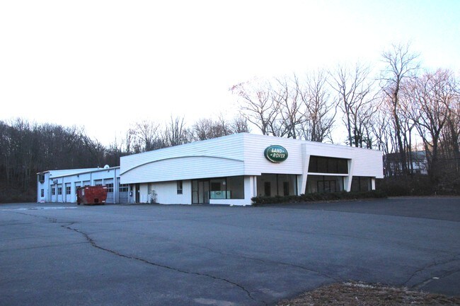
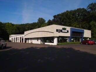
Property Record
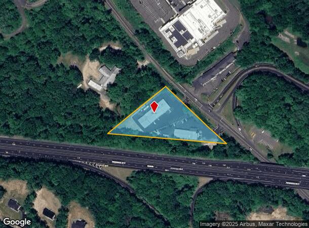
1800 Boston Post Rd, Guilford, CT 06437
NEARBY LISTINGS FOR SALE OR LEASE
Property Detail
1800 Boston Post Rd
GUIL-000000-000000-079037
New Haven
Commercialnec
Connecticut
X
2.70 AC
09009C0487J
Guilford
2024
Westchester/So Connecticut
2025
New Haven, CT
190302
DEMOGRAPHICS near 1800 Boston Post Rd
1 mile
3 mile
5 mile
2024 Total Population
1,680
16,967
41,460
2029 Population
1,677
17,023
41,656
Pop Growth 2024-2029
(0.18%)
+ 0.33%
+ 0.47%
Average Age
47
46
46
2024 Total Households
722
7,025
16,822
HH Growth 2024-2029
(0.28%)
+ 0.31%
+ 0.47%
Median Household Inc
$95,639
$118,586
$121,348
Avg Household Size
2.30
2.40
2.40
2024 Avg HH Vehicles
2.00
2.00
2.00
Median Home Value
$439,906
$446,236
$437,813
Median Year Built
1981
1973
1972
Nearby Places
Map Layers
Map Styles
 Street
 Aerial
Transit
 Traffic
 Biking
Places
Listings with unknown addresses are not visible on the map
- Restaurants
- Banks
- Shops
- Fitness
- Groceries
PUBLIC TRANSPORTATION
COMMUTER RAIL
Drive
Walk
Distance
6 min
2.7 mi
Guilford (Shore Line East - Shore Line East)
Drive
Walk
Distance
Guilford (Shore Line East - Shore Line East)
6 min
2.7 mi
AIRPORT
Tweed/New Haven
Drive
Walk
Distance
Tweed/New Haven
17 min
10.8 mi
Freight Ports
Port of New Haven
Drive
Walk
Distance
Port of New Haven
17 min
11.4 mi
SALE & LEASE HISTORY
LISTING DATE
SALE/LEASE

Dec 27, 2018
For Lease
Nearby Properties
Address
Land Use
TOTAL SIZE
Lot Size
Zoning
Address
Land Use
TOTAL SIZE
Lot Size
Zoning
30 AC
R-5
Address
Land Use
TOTAL SIZE
Lot Size
Zoning
88.66 AC
I3
Address
Land Use
TOTAL SIZE
Lot Size
Zoning
51,202 SF
19 AC
R-3
Address
Land Use
TOTAL SIZE
Lot Size
Zoning
27.83 AC
SC
Address
Land Use
TOTAL SIZE
Lot Size
Zoning
20,430 SF
6.47 AC
PRB3
Address
Land Use
TOTAL SIZE
Lot Size
Zoning
42,921 SF
12.19 AC
R-4
Address
Land Use
TOTAL SIZE
Lot Size
Zoning
94,060 SF
18.20 AC
R-1
Address
Land Use
TOTAL SIZE
Lot Size
Zoning
49,294 SF
7.19 AC
C
Address
Land Use
TOTAL SIZE
Lot Size
Zoning
8.29 AC
Address
Land Use
TOTAL SIZE
Lot Size
Zoning
142,136 SF
58.31 AC
R-8
Address
Land Use
TOTAL SIZE
Lot Size
Zoning
79,294 SF
44 AC
R-5
Address
Land Use
TOTAL SIZE
Lot Size
Zoning
3.20 AC
PRB1
Address
Land Use
TOTAL SIZE
Lot Size
Zoning
2,196 SF
1.68 AC
PRB3
Address
Land Use
TOTAL SIZE
Lot Size
Zoning
49,145 SF
20.54 AC
R-3
Address
Land Use
TOTAL SIZE
Lot Size
Zoning
Address
Land Use
TOTAL SIZE
Lot Size
Zoning
30,530 SF
0.55 AC
R-1
Address
Land Use
TOTAL SIZE
Lot Size
Zoning
15.10 AC
Address
Land Use
TOTAL SIZE
Lot Size
Zoning
166,717 SF
SC
Address
Land Use
TOTAL SIZE
Lot Size
Zoning
9.80 AC
I
Address
Land Use
TOTAL SIZE
Lot Size
Zoning
45,766 SF
7.71 AC
R-7
Address
Land Use
TOTAL SIZE
Lot Size
Zoning
58,910 SF
5.17 AC
Address
Land Use
TOTAL SIZE
Lot Size
Zoning
58,260 SF
8.59 AC
I
Address
Land Use
TOTAL SIZE
Lot Size
Zoning
38,352 SF
24 AC
Address
Land Use
TOTAL SIZE
Lot Size
Zoning
9,000 SF
2.17 AC
R-5I
Address
Land Use
TOTAL SIZE
Lot Size
Zoning
3,094 SF
16 AC
BMU
Address
Land Use
TOTAL SIZE
Lot Size
Zoning
36,856 SF
3.10 AC
Address
Land Use
TOTAL SIZE
Lot Size
Zoning
26,326 SF
3.45 AC
R-1
Address
Land Use
TOTAL SIZE
Lot Size
Zoning
10.90 AC
Address
Land Use
TOTAL SIZE
Lot Size
Zoning
1,500 SF
598.50 AC
R-6
Address
Land Use
TOTAL SIZE
Lot Size
Zoning
22,458 SF
6.44 AC
I
The World's #1 Commercial Real Estate Marketplace
Connect with us
© 2026 CoStar Group
The information above has been obtained from sources believed reliable. While we do not doubt its accuracy we have not verified it and make no guarantee, warranty or representation about it. It is your responsibility to independently confirm its accuracy and completeness. Any projections, opinions, assumptions, or estimates used are for example only and do not represent the current or future performance of the property. The value of this transaction to you depends on tax and other factors which should be evaluated by your tax, financial, and legal advisors. You and your advisors should conduct a careful, independent investigation of the property to determine to your satisfaction the suitability of the property for your needs.