Property Record
1800 Farmington Ave, Unionville, CT 06085
NEARBY LISTINGS FOR SALE OR LEASE
-
-
View all Unionville listings for sale on LoopNet.com
Property Detail
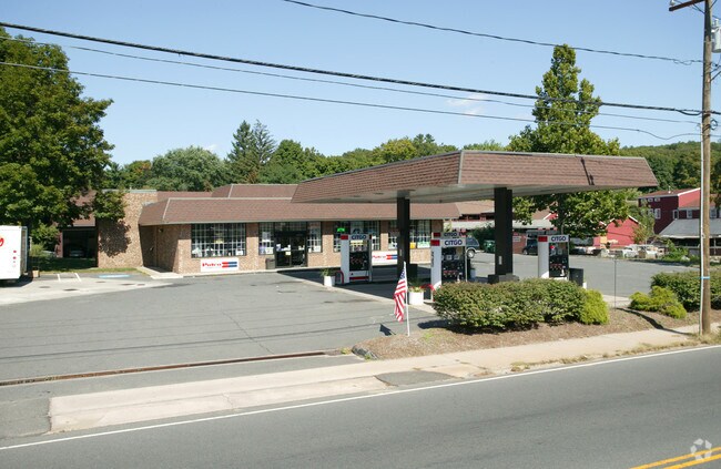
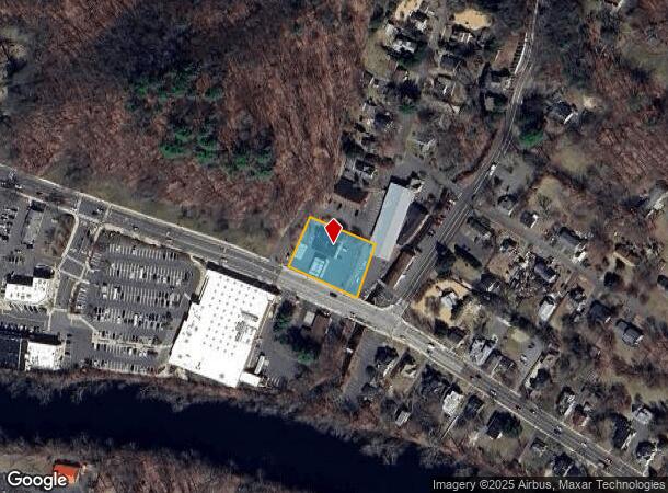
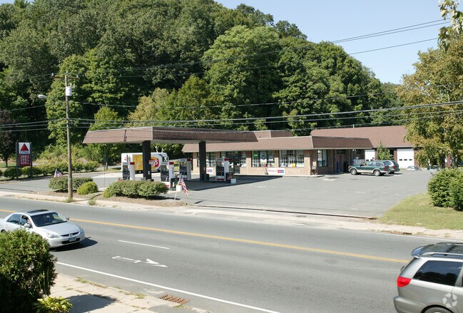
1800 Farmington Ave
Servicestation
Hartford
X
Connecticut
09003C0319F
0.84 AC
2025
Farmington
2025
Hartford
460302
Hartford-West Hartford-East Hartford, CT
3,084 SF
FARM-000012-000000-000058
DEMOGRAPHICS near 1800 Farmington Ave
1 Mile
3 Mile
5 Mile
2024 Total Population
6,148
28,436
73,510
2029 Population
6,115
28,316
73,434
Pop Growth 2024-2029
(0.54%)
(0.42%)
(0.10%)
Average Age
44
43
43
2024 Total Households
2,650
11,035
29,645
HH Growth 2024-2029
(0.57%)
(0.42%)
(0.10%)
Median Household Inc
$112,307
$126,058
$108,953
Avg Household Size
2.30
2.50
2.40
2024 Avg HH Vehicles
2.00
2.00
2.00
Median Home Value
$362,109
$387,147
$343,304
Median Year Built
1973
1978
1975
Nearby Places
Map Layers
Map Styles
 Street
 Aerial
- Restaurants
- Banks
- Shops
- Fitness
- Groceries
PUBLIC TRANSPORTATION
AIRPORT
Bradley International
DRIVE
WALK
Distance
Bradley International
48 min
22.4 mi
Freight Ports
Port of New Haven
DRIVE
WALK
Distance
Port of New Haven
51 min
37.3 mi
SALE & LEASE HISTORY
LISTING DATE
SALE/LEASE

Jan 24, 2020
For Sale
Nearby Properties
Address
Land Use
TOTAL SIZE
Lot Size
Zoning
Address
Land Use
TOTAL SIZE
Lot Size
Zoning
39.86 AC
R40
Address
Land Use
TOTAL SIZE
Lot Size
Zoning
234.01 AC
EL
Address
Land Use
TOTAL SIZE
Lot Size
Zoning
39.45 AC
R80
Address
Land Use
TOTAL SIZE
Lot Size
Zoning
11.16 AC
R30
Address
Land Use
TOTAL SIZE
Lot Size
Zoning
14.77 AC
R-40
Address
Land Use
TOTAL SIZE
Lot Size
Zoning
12 AC
R20
Address
Land Use
TOTAL SIZE
Lot Size
Zoning
120,310 SF
13.43 AC
BR
Address
Land Use
TOTAL SIZE
Lot Size
Zoning
18.52 AC
R40
Address
Land Use
TOTAL SIZE
Lot Size
Zoning
21.24 AC
R40
Address
Land Use
TOTAL SIZE
Lot Size
Zoning
24.61 AC
CR
Address
Land Use
TOTAL SIZE
Lot Size
Zoning
173,619 SF
20 AC
SA
Address
Land Use
TOTAL SIZE
Lot Size
Zoning
13.20 AC
CR
Address
Land Use
TOTAL SIZE
Lot Size
Zoning
20 AC
R30
Address
Land Use
TOTAL SIZE
Lot Size
Zoning
46,768 SF
40.04 AC
R40
Address
Land Use
TOTAL SIZE
Lot Size
Zoning
38,901 SF
10 AC
R20
Address
Land Use
TOTAL SIZE
Lot Size
Zoning
3.80 AC
Address
Land Use
TOTAL SIZE
Lot Size
Zoning
25,596 SF
8.18 AC
R80
Address
Land Use
TOTAL SIZE
Lot Size
Zoning
15.90 AC
R40
Address
Land Use
TOTAL SIZE
Lot Size
Zoning
69,788 SF
13.80 AC
RDM
Address
Land Use
TOTAL SIZE
Lot Size
Zoning
23,648 SF
R80
Address
Land Use
TOTAL SIZE
Lot Size
Zoning
273.48 AC
R40
Address
Land Use
TOTAL SIZE
Lot Size
Zoning
50,792 SF
2.86 AC
UC
Address
Land Use
TOTAL SIZE
Lot Size
Zoning
82,644 SF
7.11 AC
CR
Address
Land Use
TOTAL SIZE
Lot Size
Zoning
85,302 SF
27.94 AC
R44
Address
Land Use
TOTAL SIZE
Lot Size
Zoning
14,358 SF
2.10 AC
UC
Address
Land Use
TOTAL SIZE
Lot Size
Zoning
8.04 AC
R40
Address
Land Use
TOTAL SIZE
Lot Size
Zoning
10.48 AC
PR
Address
Land Use
TOTAL SIZE
Lot Size
Zoning
14,039 SF
1.50 AC
R20
Address
Land Use
TOTAL SIZE
Lot Size
Zoning
9,460 SF
1.20 AC
UC
Address
Land Use
TOTAL SIZE
Lot Size
Zoning
13 AC
R80
The World's #1 Commercial Real Estate Marketplace
Connect with us
© 2025 CoStar Group
The information above has been obtained from sources believed reliable. While we do not doubt its accuracy we have not verified it and make no guarantee, warranty or representation about it. It is your responsibility to independently confirm its accuracy and completeness. Any projections, opinions, assumptions, or estimates used are for example only and do not represent the current or future performance of the property. The value of this transaction to you depends on tax and other factors which should be evaluated by your tax, financial, and legal advisors. You and your advisors should conduct a careful, independent investigation of the property to determine to your satisfaction the suitability of the property for your needs.