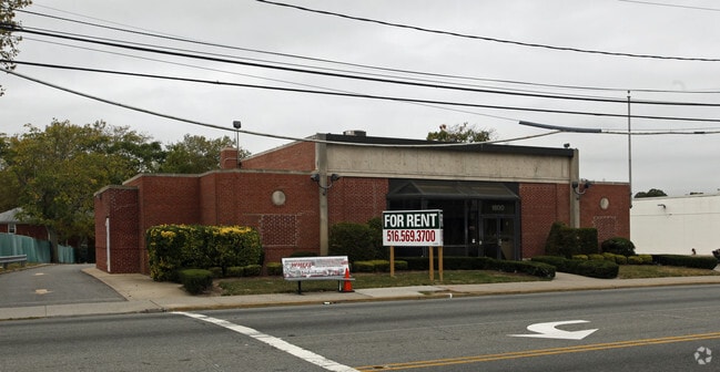
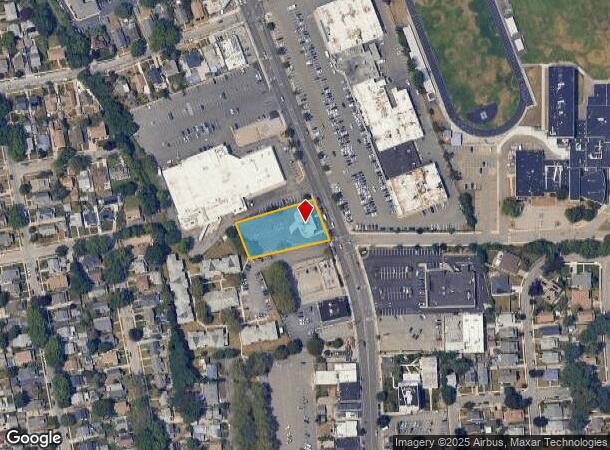
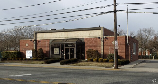
Property Record
1800 Grand Ave, North Baldwin, NY 11510

NEARBY LISTINGS FOR SALE OR LEASE
Property Detail
1800 Grand Ave
2089-36-409-00-0601-0
TOWN #1 SCH DIST 010
Financialbuilding
Nassau
X
New York
36059C0236G
601
2025
0.68 AC
2025
Southern Nassau
413500
Long Island (New York)
6,309 SF
Nassau County-Suffolk County, NY
DEMOGRAPHICS near 1800 Grand Ave
1 Mile
3 Mile
5 Mile
2024 Total Population
28,623
231,125
499,528
2029 Population
28,089
227,098
489,581
Pop Growth 2024-2029
(1.87%)
(1.74%)
(1.99%)
Average Age
40
40
41
2024 Total Households
8,499
69,467
156,834
HH Growth 2024-2029
(2.05%)
(1.80%)
(2.09%)
Median Household Inc
$134,346
$114,356
$120,577
Avg Household Size
3.20
3.10
3.00
2024 Avg HH Vehicles
2.00
2.00
2.00
Median Home Value
$495,646
$514,815
$613,843
Median Year Built
1947
1951
1953
Nearby Places
- Restaurants
- Banks
- Shops
- Fitness
- Groceries
PUBLIC TRANSPORTATION
COMMUTER RAIL
Baldwin Station (Babylon Branch - Long Island Rail Road)
DRIVE
WALK
Distance
Baldwin Station (Babylon Branch - Long Island Rail Road)
2 min
15 min
0.8 mi
Freeport Station (Babylon Branch - Long Island Rail Road)
DRIVE
WALK
Distance
Freeport Station (Babylon Branch - Long Island Rail Road)
4 min
2.3 mi
AIRPORT
John F Kennedy International
DRIVE
WALK
Distance
John F Kennedy International
20 min
12.7 mi
LaGuardia
DRIVE
WALK
Distance
LaGuardia
30 min
19.6 mi
Long Island MacArthur
DRIVE
WALK
Distance
Long Island MacArthur
43 min
31.8 mi
Freight Ports
NY - Red Hook Container Terminal
DRIVE
WALK
Distance
NY - Red Hook Container Terminal
41 min
24.1 mi
Nearby Properties
Address
Land Use
TOTAL SIZE
Lot Size
Zoning
Address
Land Use
TOTAL SIZE
Lot Size
Zoning
202.54 AC
Address
Land Use
TOTAL SIZE
Lot Size
Zoning
Address
Land Use
TOTAL SIZE
Lot Size
Zoning
186 AC
Address
Land Use
TOTAL SIZE
Lot Size
Zoning
5,800 SF
10.48 AC
Address
Land Use
TOTAL SIZE
Lot Size
Zoning
169.25 AC
Address
Land Use
TOTAL SIZE
Lot Size
Zoning
336,450 SF
139.91 AC
Address
Land Use
TOTAL SIZE
Lot Size
Zoning
341,098 SF
31.88 AC
Address
Land Use
TOTAL SIZE
Lot Size
Zoning
19.88 AC
Address
Land Use
TOTAL SIZE
Lot Size
Zoning
57,970 SF
1.69 AC
Address
Land Use
TOTAL SIZE
Lot Size
Zoning
65,235 SF
15.48 AC
Address
Land Use
TOTAL SIZE
Lot Size
Zoning
94,204 SF
35.42 AC
Address
Land Use
TOTAL SIZE
Lot Size
Zoning
46,404 SF
38.43 AC
Address
Land Use
TOTAL SIZE
Lot Size
Zoning
145,209 SF
20.01 AC
Address
Land Use
TOTAL SIZE
Lot Size
Zoning
140,000 SF
50.78 AC
Address
Land Use
TOTAL SIZE
Lot Size
Zoning
29,998 SF
22.49 AC
Address
Land Use
TOTAL SIZE
Lot Size
Zoning
76.10 AC
Address
Land Use
TOTAL SIZE
Lot Size
Zoning
83.42 AC
Address
Land Use
TOTAL SIZE
Lot Size
Zoning
115.42 AC
Address
Land Use
TOTAL SIZE
Lot Size
Zoning
151,757 SF
34.38 AC
Address
Land Use
TOTAL SIZE
Lot Size
Zoning
126,558 SF
12.76 AC
Address
Land Use
TOTAL SIZE
Lot Size
Zoning
225,460 SF
14.70 AC
Address
Land Use
TOTAL SIZE
Lot Size
Zoning
293,443 SF
21.86 AC
Address
Land Use
TOTAL SIZE
Lot Size
Zoning
20,670 SF
6.62 AC
Address
Land Use
TOTAL SIZE
Lot Size
Zoning
86.38 AC
Address
Land Use
TOTAL SIZE
Lot Size
Zoning
357,868 SF
24.92 AC
Address
Land Use
TOTAL SIZE
Lot Size
Zoning
377,041 SF
14.43 AC
Address
Land Use
TOTAL SIZE
Lot Size
Zoning
63.32 AC
Address
Land Use
TOTAL SIZE
Lot Size
Zoning
140,992 SF
12.07 AC
Address
Land Use
TOTAL SIZE
Lot Size
Zoning
74,813 SF
4.56 AC
Address
Land Use
TOTAL SIZE
Lot Size
Zoning
253,201 SF
16.01 AC
The World's #1 Commercial Real Estate Marketplace
Connect with us
© 2025 CoStar Group
The information above has been obtained from sources believed reliable. While we do not doubt its accuracy we have not verified it and make no guarantee, warranty or representation about it. It is your responsibility to independently confirm its accuracy and completeness. Any projections, opinions, assumptions, or estimates used are for example only and do not represent the current or future performance of the property. The value of this transaction to you depends on tax and other factors which should be evaluated by your tax, financial, and legal advisors. You and your advisors should conduct a careful, independent investigation of the property to determine to your satisfaction the suitability of the property for your needs.