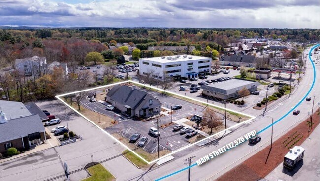
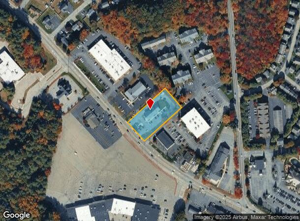
Property Record
1800 Main St, Tewksbury, MA 01876

NEARBY LISTINGS FOR SALE OR LEASE
Property Detail
1800 Main St
TEWK-000085-000000-000126
Middlesex
Restaurantbuilding
Massachusetts
X
126
25017C0279G
1.03 AC
2025
Lowell/Chelmsford
2025
Boston
315401
Boston-Cambridge-Newton, MA-NH
3,684 SF
DEMOGRAPHICS near 1800 Main St
1 Mile
3 Mile
5 Mile
2024 Total Population
7,059
43,532
120,235
2029 Population
6,967
42,982
118,993
Pop Growth 2024-2029
(1.30%)
(1.26%)
(1.03%)
Average Age
46
43
42
2024 Total Households
2,840
15,840
43,315
HH Growth 2024-2029
(1.41%)
(1.35%)
(1.13%)
Median Household Inc
$103,146
$120,144
$124,636
Avg Household Size
2.30
2.70
2.70
2024 Avg HH Vehicles
2.00
2.00
2.00
Median Home Value
$452,447
$542,443
$575,162
Median Year Built
1982
1979
1974
Nearby Places
Map Layers
Map Styles
 Street
 Aerial
- Restaurants
- Banks
- Shops
- Fitness
- Groceries
PUBLIC TRANSPORTATION
COMMUTER RAIL
North Wilmington (Haverhill Line - Massachusetts Bay Transportation Authority Commuter Rail (Purple Line))
DRIVE
WALK
Distance
North Wilmington (Haverhill Line - Massachusetts Bay Transportation Authority Commuter Rail (Purple Line))
9 min
3.7 mi
Wilmington (Lowell Line - Massachusetts Bay Transportation Authority Commuter Rail (Purple Line))
DRIVE
WALK
Distance
Wilmington (Lowell Line - Massachusetts Bay Transportation Authority Commuter Rail (Purple Line))
7 min
3.8 mi
AIRPORT
General Edward Lawrence Logan International
DRIVE
WALK
Distance
General Edward Lawrence Logan International
35 min
22.1 mi
Manchester Boston Regional
DRIVE
WALK
Distance
Manchester Boston Regional
50 min
34.1 mi
Portsmouth International at Pease
DRIVE
WALK
Distance
Portsmouth International at Pease
64 min
48.6 mi
Freight Ports
Port of Boston
DRIVE
WALK
Distance
Port of Boston
35 min
21.9 mi
SALE & LEASE HISTORY
LISTING DATE
SALE/LEASE

Nov 08, 2019
For Sale
May 15, 2023
For Sale
Nearby Properties
Address
Land Use
TOTAL SIZE
Lot Size
Zoning
Address
Land Use
TOTAL SIZE
Lot Size
Zoning
272,632 SF
22.49 AC
IND
Address
Land Use
TOTAL SIZE
Lot Size
Zoning
25 AC
MN
Address
Land Use
TOTAL SIZE
Lot Size
Zoning
1,616 SF
206.08 AC
R40
Address
Land Use
TOTAL SIZE
Lot Size
Zoning
341,215 SF
16.94 AC
IND
Address
Land Use
TOTAL SIZE
Lot Size
Zoning
591,906 SF
153.43 AC
IA
Address
Land Use
TOTAL SIZE
Lot Size
Zoning
110,162 SF
16.67 AC
5
Address
Land Use
TOTAL SIZE
Lot Size
Zoning
19.04 AC
MFD
Address
Land Use
TOTAL SIZE
Lot Size
Zoning
218,780 SF
55.49 AC
MN
Address
Land Use
TOTAL SIZE
Lot Size
Zoning
343,105 SF
60.18 AC
IND
Address
Land Use
TOTAL SIZE
Lot Size
Zoning
40.44 AC
MFD
Address
Land Use
TOTAL SIZE
Lot Size
Zoning
264,976 SF
34.74 AC
Address
Land Use
TOTAL SIZE
Lot Size
Zoning
221,927 SF
27.88 AC
IND
Address
Land Use
TOTAL SIZE
Lot Size
Zoning
161,736 SF
13.91 AC
Address
Land Use
TOTAL SIZE
Lot Size
Zoning
193.30 AC
IA
Address
Land Use
TOTAL SIZE
Lot Size
Zoning
447,869 SF
27.06 AC
ID
Address
Land Use
TOTAL SIZE
Lot Size
Zoning
484,857 SF
42.05 AC
HI
Address
Land Use
TOTAL SIZE
Lot Size
Zoning
150,335 SF
23.33 AC
COM
Address
Land Use
TOTAL SIZE
Lot Size
Zoning
9.80 AC
R40
Address
Land Use
TOTAL SIZE
Lot Size
Zoning
180,640 SF
16.24 AC
ID2
Address
Land Use
TOTAL SIZE
Lot Size
Zoning
113,912 SF
5.67 AC
MFD
Address
Land Use
TOTAL SIZE
Lot Size
Zoning
107,001 SF
21.82 AC
MN
Address
Land Use
TOTAL SIZE
Lot Size
Zoning
26.32 AC
IA
Address
Land Use
TOTAL SIZE
Lot Size
Zoning
133,877 SF
16.30 AC
IND
Address
Land Use
TOTAL SIZE
Lot Size
Zoning
167,654 SF
14.84 AC
GI
Address
Land Use
TOTAL SIZE
Lot Size
Zoning
120,682 SF
12.03 AC
ID2
Address
Land Use
TOTAL SIZE
Lot Size
Zoning
123,700 SF
9.43 AC
Address
Land Use
TOTAL SIZE
Lot Size
Zoning
106,035 SF
8.65 AC
IND
Address
Land Use
TOTAL SIZE
Lot Size
Zoning
187,898 SF
14 AC
IND
Address
Land Use
TOTAL SIZE
Lot Size
Zoning
70,470 SF
20.51 AC
R20/60
Address
Land Use
TOTAL SIZE
Lot Size
Zoning
111,758 SF
6.72 AC
IND
The World's #1 Commercial Real Estate Marketplace
Connect with us
© 2025 CoStar Group
The information above has been obtained from sources believed reliable. While we do not doubt its accuracy we have not verified it and make no guarantee, warranty or representation about it. It is your responsibility to independently confirm its accuracy and completeness. Any projections, opinions, assumptions, or estimates used are for example only and do not represent the current or future performance of the property. The value of this transaction to you depends on tax and other factors which should be evaluated by your tax, financial, and legal advisors. You and your advisors should conduct a careful, independent investigation of the property to determine to your satisfaction the suitability of the property for your needs.