Property Record
1800 Millersville Rd, Lancaster, PA 17603

NEARBY LISTINGS FOR SALE OR LEASE
Property Detail
1800 Millersville Rd
Lancaster, PA
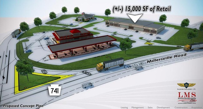
Millersville Commons
340-79050-0-0000
1800 MILLERSVILLE RD
Recreationalentertainmentgeneral
Lancaster
X
Pennsylvania
42071C0364F
1
2024
37.02 AC
2025
Lancaster County
013502
Philadelphia
3,968 SF
DEMOGRAPHICS near 1800 Millersville Rd
1 Mile
3 Mile
5 Mile
2024 Total Population
8,255
74,133
155,569
2029 Population
8,308
74,712
156,605
Pop Growth 2024-2029
+ 0.64%
+ 0.78%
+ 0.67%
Average Age
36
38
40
2024 Total Households
2,532
27,917
60,133
HH Growth 2024-2029
+ 0.08%
+ 0.74%
+ 0.55%
Median Household Inc
$79,614
$67,318
$71,105
Avg Household Size
2.40
2.40
2.40
2024 Avg HH Vehicles
2.00
2.00
2.00
Median Home Value
$208,136
$199,389
$227,209
Median Year Built
1970
1959
1965
Nearby Places
Map Layers
Map Styles
 Street
 Aerial
- Restaurants
- Banks
- Shops
- Fitness
- Groceries
PUBLIC TRANSPORTATION
COMMUTER RAIL
Lancaster (Keystone Service - Amtrak, Pennsylvanian - Amtrak)
DRIVE
WALK
Distance
Lancaster (Keystone Service - Amtrak, Pennsylvanian - Amtrak)
11 min
4.9 mi
AIRPORT
Harrisburg International
DRIVE
WALK
Distance
Harrisburg International
48 min
33.8 mi
Freight Ports
Port of Wilmington, RI
DRIVE
WALK
Distance
Port of Wilmington, RI
94 min
65.4 mi
Nearby Properties
Address
Land Use
TOTAL SIZE
Lot Size
Zoning
Address
Land Use
TOTAL SIZE
Lot Size
Zoning
206,666 SF
1 AC
CB1
Address
Land Use
TOTAL SIZE
Lot Size
Zoning
269,860 SF
0.90 AC
CB1
Address
Land Use
TOTAL SIZE
Lot Size
Zoning
610,085 SF
57.70 AC
R1A
Address
Land Use
TOTAL SIZE
Lot Size
Zoning
941,905 SF
141.50 AC
I
Address
Land Use
TOTAL SIZE
Lot Size
Zoning
224,054 SF
71 AC
Address
Land Use
TOTAL SIZE
Lot Size
Zoning
307,696 SF
29 AC
R1
Address
Land Use
TOTAL SIZE
Lot Size
Zoning
288,628 SF
27.80 AC
R1A
Address
Land Use
TOTAL SIZE
Lot Size
Zoning
35,920 SF
35.68 AC
Address
Land Use
TOTAL SIZE
Lot Size
Zoning
135,998 SF
28.64 AC
HR
Address
Land Use
TOTAL SIZE
Lot Size
Zoning
199,107 SF
26.20 AC
CC
Address
Land Use
TOTAL SIZE
Lot Size
Zoning
138,618 SF
9.53 AC
Address
Land Use
TOTAL SIZE
Lot Size
Zoning
98,798 SF
42.19 AC
Address
Land Use
TOTAL SIZE
Lot Size
Zoning
123,664 SF
1.60 AC
R1A
Address
Land Use
TOTAL SIZE
Lot Size
Zoning
166,685 SF
14.90 AC
R1A
Address
Land Use
TOTAL SIZE
Lot Size
Zoning
172,568 SF
9.76 AC
R3
Address
Land Use
TOTAL SIZE
Lot Size
Zoning
152,451 SF
0.84 AC
CB1
Address
Land Use
TOTAL SIZE
Lot Size
Zoning
281,887 SF
19.29 AC
R-3
Address
Land Use
TOTAL SIZE
Lot Size
Zoning
175,971 SF
20.40 AC
Address
Land Use
TOTAL SIZE
Lot Size
Zoning
461,643 SF
1 AC
CB1
Address
Land Use
TOTAL SIZE
Lot Size
Zoning
109,347 SF
12.70 AC
C-3
Address
Land Use
TOTAL SIZE
Lot Size
Zoning
101,204 SF
6 AC
R1A
Address
Land Use
TOTAL SIZE
Lot Size
Zoning
134,167 SF
1.62 AC
MU
Address
Land Use
TOTAL SIZE
Lot Size
Zoning
226,692 SF
12.80 AC
Address
Land Use
TOTAL SIZE
Lot Size
Zoning
278,244 SF
29.90 AC
R-3
Address
Land Use
TOTAL SIZE
Lot Size
Zoning
107,181 SF
19.89 AC
Address
Land Use
TOTAL SIZE
Lot Size
Zoning
65,006 SF
0.57 AC
CB1
Address
Land Use
TOTAL SIZE
Lot Size
Zoning
0.56 AC
Address
Land Use
TOTAL SIZE
Lot Size
Zoning
122,820 SF
11.80 AC
R-3
Address
Land Use
TOTAL SIZE
Lot Size
Zoning
91,536 SF
7.60 AC
Address
Land Use
TOTAL SIZE
Lot Size
Zoning
92,914 SF
17.07 AC
S
The World's #1 Commercial Real Estate Marketplace
Connect with us
© 2025 CoStar Group
The information above has been obtained from sources believed reliable. While we do not doubt its accuracy we have not verified it and make no guarantee, warranty or representation about it. It is your responsibility to independently confirm its accuracy and completeness. Any projections, opinions, assumptions, or estimates used are for example only and do not represent the current or future performance of the property. The value of this transaction to you depends on tax and other factors which should be evaluated by your tax, financial, and legal advisors. You and your advisors should conduct a careful, independent investigation of the property to determine to your satisfaction the suitability of the property for your needs.