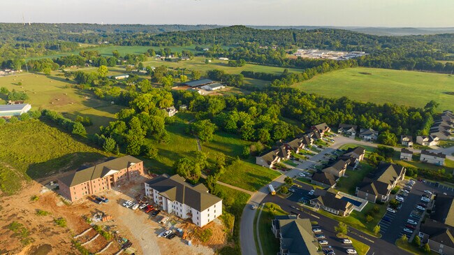
Property Record
1800-265 Morgantown Rd, Bowling Green, KY 42101
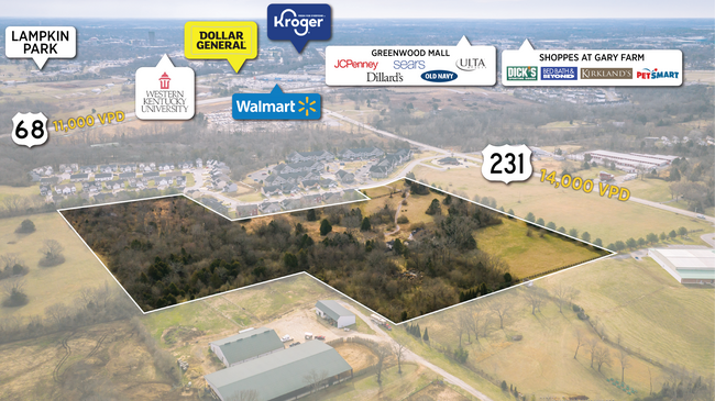


NEARBY LISTINGS FOR SALE OR LEASE
Property Detail
1800-265 Morgantown Rd
027A-01
Briarwood Manor
Commercialnec
Warren
X
Kentucky
21227C0301E
18 AC
2025
Bowling Green Area
2025
Other Market Areas
011200
Bowling Green, KY
4,254 SF
DEMOGRAPHICS near 1800-265 Morgantown Rd
1 Mile
3 Mile
5 Mile
2024 Total Population
4,387
39,511
69,690
2029 Population
4,807
43,111
76,316
Pop Growth 2024-2029
+ 9.57%
+ 9.11%
+ 9.51%
Average Age
32
32
35
2024 Total Households
1,658
13,934
26,860
HH Growth 2024-2029
+ 9.89%
+ 9.99%
+ 10.19%
Median Household Inc
$46,222
$35,376
$44,776
Avg Household Size
2.50
2.40
2.30
2024 Avg HH Vehicles
2.00
2.00
2.00
Median Home Value
$146,715
$150,192
$204,165
Median Year Built
1998
1985
1986
Nearby Places
Map Layers
Map Styles
 Street
 Aerial
- Restaurants
- Banks
- Shops
- Fitness
- Groceries
SALE & LEASE HISTORY
LISTING DATE
SALE/LEASE

Sep 26, 2023
For Sale
Apr 19, 2021
For Sale
Nearby Properties
Address
Land Use
TOTAL SIZE
Lot Size
Zoning
Address
Land Use
TOTAL SIZE
Lot Size
Zoning
117,551 SF
5.06 AC
Address
Land Use
TOTAL SIZE
Lot Size
Zoning
150,327 SF
2.54 AC
Address
Land Use
TOTAL SIZE
Lot Size
Zoning
36,984 SF
7.26 AC
Address
Land Use
TOTAL SIZE
Lot Size
Zoning
Address
Land Use
TOTAL SIZE
Lot Size
Zoning
19.61 AC
Address
Land Use
TOTAL SIZE
Lot Size
Zoning
214,273 SF
26.97 AC
Address
Land Use
TOTAL SIZE
Lot Size
Zoning
Address
Land Use
TOTAL SIZE
Lot Size
Zoning
Address
Land Use
TOTAL SIZE
Lot Size
Zoning
Address
Land Use
TOTAL SIZE
Lot Size
Zoning
Address
Land Use
TOTAL SIZE
Lot Size
Zoning
17,010 SF
9.64 AC
Address
Land Use
TOTAL SIZE
Lot Size
Zoning
2,946 SF
3.59 AC
Address
Land Use
TOTAL SIZE
Lot Size
Zoning
82,675 SF
5.02 AC
Address
Land Use
TOTAL SIZE
Lot Size
Zoning
283,545 SF
38.28 AC
Address
Land Use
TOTAL SIZE
Lot Size
Zoning
38,782 SF
4.05 AC
Address
Land Use
TOTAL SIZE
Lot Size
Zoning
1,101 SF
16.07 AC
Address
Land Use
TOTAL SIZE
Lot Size
Zoning
3,200 SF
8.61 AC
Address
Land Use
TOTAL SIZE
Lot Size
Zoning
241,486 SF
23.20 AC
Address
Land Use
TOTAL SIZE
Lot Size
Zoning
13,277 SF
1.21 AC
Address
Land Use
TOTAL SIZE
Lot Size
Zoning
168,353 SF
37.76 AC
Address
Land Use
TOTAL SIZE
Lot Size
Zoning
15,450 SF
11.78 AC
Address
Land Use
TOTAL SIZE
Lot Size
Zoning
63,584 SF
6.43 AC
Address
Land Use
TOTAL SIZE
Lot Size
Zoning
43,663 SF
8.77 AC
Address
Land Use
TOTAL SIZE
Lot Size
Zoning
11,568 SF
2.30 AC
Address
Land Use
TOTAL SIZE
Lot Size
Zoning
17,280 SF
8.89 AC
Address
Land Use
TOTAL SIZE
Lot Size
Zoning
159,256 SF
11.44 AC
Address
Land Use
TOTAL SIZE
Lot Size
Zoning
8,458 SF
2.78 AC
Address
Land Use
TOTAL SIZE
Lot Size
Zoning
27,100 SF
8.43 AC
Address
Land Use
TOTAL SIZE
Lot Size
Zoning
4,608 SF
8 AC
Address
Land Use
TOTAL SIZE
Lot Size
Zoning
468,214 SF
50.34 AC
The World's #1 Commercial Real Estate Marketplace
Connect with us
© 2025 CoStar Group
The information above has been obtained from sources believed reliable. While we do not doubt its accuracy we have not verified it and make no guarantee, warranty or representation about it. It is your responsibility to independently confirm its accuracy and completeness. Any projections, opinions, assumptions, or estimates used are for example only and do not represent the current or future performance of the property. The value of this transaction to you depends on tax and other factors which should be evaluated by your tax, financial, and legal advisors. You and your advisors should conduct a careful, independent investigation of the property to determine to your satisfaction the suitability of the property for your needs.