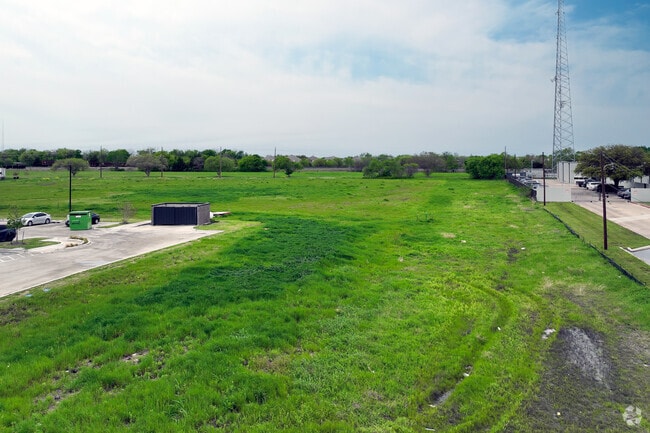
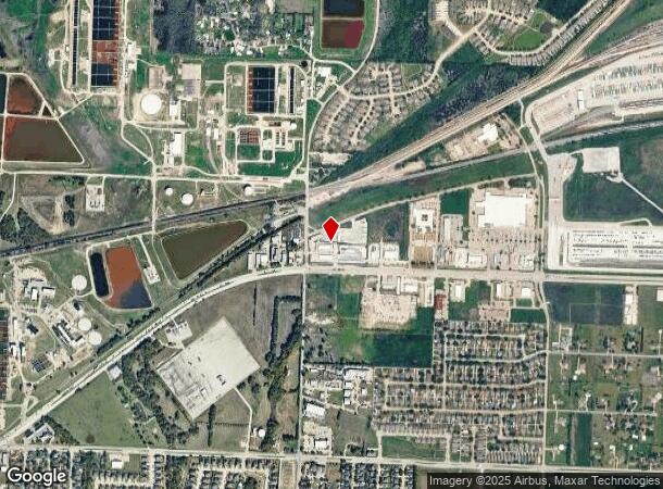
Property Record
1800 N Highway 78 Cir, Wylie, TX 75098

NEARBY LISTINGS FOR SALE OR LEASE
Property Detail
1800 N Highway 78 Cir
Dallas-Fort Worth-Arlington, TX
Woodlake Village (Cwy)
R-2381-00A-0010-1
WOODLAKE VILLAGE, BLK A, LOT 1; * REPLAT *
Commercialnec
Collin
X
Texas
48113C0100K
1
2023
5.55 AC
2025
Murphy/Wylie
031308
Dallas/Ft Worth
9,952 SF
DEMOGRAPHICS near 1800 N Highway 78 Cir
1 Mile
3 Mile
5 Mile
2024 Total Population
4,740
41,882
107,335
2029 Population
5,780
51,123
130,159
Pop Growth 2024-2029
+ 21.94%
+ 22.06%
+ 21.26%
Average Age
37
36
36
2024 Total Households
1,569
13,369
33,746
HH Growth 2024-2029
+ 22.18%
+ 22.22%
+ 21.42%
Median Household Inc
$106,104
$103,903
$107,638
Avg Household Size
3.00
3.10
3.20
2024 Avg HH Vehicles
2.00
2.00
2.00
Median Home Value
$273,484
$297,331
$339,767
Median Year Built
2004
2004
2005
Nearby Places
Map Layers
Map Styles
 Street
 Aerial
- Restaurants
- Banks
- Shops
- Fitness
- Groceries
PUBLIC TRANSPORTATION
AIRPORT
Dallas Love Field
DRIVE
WALK
Distance
Dallas Love Field
46 min
30.8 mi
Freight Ports
Port of Shreveport
DRIVE
WALK
Distance
Port of Shreveport
223 min
195.5 mi
SALE & LEASE HISTORY
LISTING DATE
SALE/LEASE

Apr 15, 2024
For Lease
Nearby Properties
Address
Land Use
TOTAL SIZE
Lot Size
Zoning
Address
Land Use
TOTAL SIZE
Lot Size
Zoning
603,573 SF
58.20 AC
Address
Land Use
TOTAL SIZE
Lot Size
Zoning
266,957 SF
11.34 AC
MFR
Address
Land Use
TOTAL SIZE
Lot Size
Zoning
393,054 SF
55.95 AC
Address
Land Use
TOTAL SIZE
Lot Size
Zoning
257,718 SF
13.10 AC
RESIDENTIA
Address
Land Use
TOTAL SIZE
Lot Size
Zoning
274,329 SF
44.89 AC
Address
Land Use
TOTAL SIZE
Lot Size
Zoning
274,416 SF
18.40 AC
PD
Address
Land Use
TOTAL SIZE
Lot Size
Zoning
140,130 SF
19.67 AC
Address
Land Use
TOTAL SIZE
Lot Size
Zoning
85,393 SF
10 AC
Address
Land Use
TOTAL SIZE
Lot Size
Zoning
132,306 SF
7.85 AC
MF
Address
Land Use
TOTAL SIZE
Lot Size
Zoning
77,225 SF
9.59 AC
Address
Land Use
TOTAL SIZE
Lot Size
Zoning
106,866 SF
15.69 AC
Address
Land Use
TOTAL SIZE
Lot Size
Zoning
97,898 SF
10.82 AC
Address
Land Use
TOTAL SIZE
Lot Size
Zoning
203,192 SF
17.69 AC
Address
Land Use
TOTAL SIZE
Lot Size
Zoning
128,849 SF
7.70 AC
Address
Land Use
TOTAL SIZE
Lot Size
Zoning
141,396 SF
8.40 AC
NS
Address
Land Use
TOTAL SIZE
Lot Size
Zoning
304,978 SF
81.51 AC
Address
Land Use
TOTAL SIZE
Lot Size
Zoning
51,878 SF
3.30 AC
PD
Address
Land Use
TOTAL SIZE
Lot Size
Zoning
88,580 SF
38.80 AC
Address
Land Use
TOTAL SIZE
Lot Size
Zoning
145,635 SF
12.15 AC
Address
Land Use
TOTAL SIZE
Lot Size
Zoning
125,000 SF
22.42 AC
FLOOD
Address
Land Use
TOTAL SIZE
Lot Size
Zoning
91,585 SF
4.33 AC
I
Address
Land Use
TOTAL SIZE
Lot Size
Zoning
151,759 SF
14.02 AC
MF
Address
Land Use
TOTAL SIZE
Lot Size
Zoning
267,312 SF
10.05 AC
Address
Land Use
TOTAL SIZE
Lot Size
Zoning
54,240 SF
2.12 AC
MF
Address
Land Use
TOTAL SIZE
Lot Size
Zoning
33,638 SF
7.14 AC
AG
Address
Land Use
TOTAL SIZE
Lot Size
Zoning
67,031 SF
18.83 AC
Address
Land Use
TOTAL SIZE
Lot Size
Zoning
408,994 SF
33.67 AC
I
Address
Land Use
TOTAL SIZE
Lot Size
Zoning
153,740 SF
6.46 AC
Address
Land Use
TOTAL SIZE
Lot Size
Zoning
94,981 SF
11.55 AC
Address
Land Use
TOTAL SIZE
Lot Size
Zoning
40,762 SF
4.70 AC
CR
The World's #1 Commercial Real Estate Marketplace
Connect with us
© 2025 CoStar Group
The information above has been obtained from sources believed reliable. While we do not doubt its accuracy we have not verified it and make no guarantee, warranty or representation about it. It is your responsibility to independently confirm its accuracy and completeness. Any projections, opinions, assumptions, or estimates used are for example only and do not represent the current or future performance of the property. The value of this transaction to you depends on tax and other factors which should be evaluated by your tax, financial, and legal advisors. You and your advisors should conduct a careful, independent investigation of the property to determine to your satisfaction the suitability of the property for your needs.