No Photo
Property Record
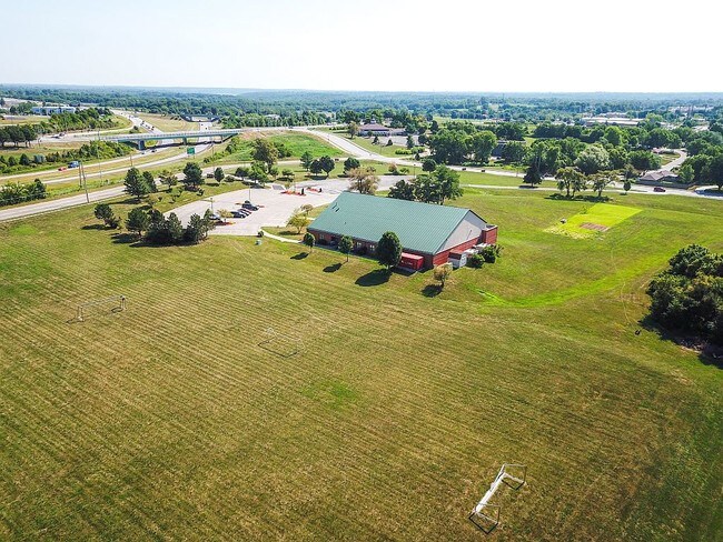
1800 Ne Independence Ave, Lees Summit, MO 64086


NEARBY LISTINGS FOR SALE OR LEASE
-
-
View all Lees Summit listings for sale on LoopNet.com
Property Detail
1800 Ne Independence Ave
Kansas City, MO-KS
New Summit Presbyterian Church
52-530-02-06-00-0-00-000
NEW SUMMIT PRESBYTERIAN CHURCH---LOT 1 (EX PT IN RD)
Religious
Jackson
X
Missouri
29095C0430G
1
0
16.29 AC
2025
Southeast Jackson County
017900
Kansas City
12,788 SF
DEMOGRAPHICS near 1800 Ne Independence Ave
1 Mile
3 Mile
5 Mile
2024 Total Population
5,496
44,204
83,559
2029 Population
5,406
43,835
83,156
Pop Growth 2024-2029
(1.64%)
(0.83%)
(0.48%)
Average Age
40
40
41
2024 Total Households
2,213
18,288
32,462
HH Growth 2024-2029
(1.67%)
(0.72%)
(0.53%)
Median Household Inc
$90,705
$82,919
$95,436
Avg Household Size
2.40
2.40
2.50
2024 Avg HH Vehicles
2.00
2.00
2.00
Median Home Value
$234,777
$243,442
$277,401
Median Year Built
1988
1983
1989
Nearby Places
Map Layers
Map Styles
 Street
 Aerial
- Restaurants
- Banks
- Shops
- Fitness
- Groceries
PUBLIC TRANSPORTATION
COMMUTER RAIL
Lee's Summit Amtrak (Lincoln Service Missouri River Runner - Amtrak, Missouri River Runner - Amtrak)
DRIVE
WALK
Distance
Lee's Summit Amtrak (Lincoln Service Missouri River Runner - Amtrak, Missouri River Runner - Amtrak)
8 min
3.5 mi
Freight Ports
Tulsa Port Of Catoosa
DRIVE
WALK
Distance
Tulsa Port Of Catoosa
266 min
240.7 mi
SALE & LEASE HISTORY
LISTING DATE
SALE/LEASE

Mar 13, 2020
For Sale
Jul 17, 2018
For Sale
Nearby Properties
Address
Land Use
TOTAL SIZE
Lot Size
Zoning
Address
Land Use
TOTAL SIZE
Lot Size
Zoning
474,121 SF
40.14 AC
Address
Land Use
TOTAL SIZE
Lot Size
Zoning
535,500 SF
54.13 AC
Address
Land Use
TOTAL SIZE
Lot Size
Zoning
480,000 SF
45.89 AC
Address
Land Use
TOTAL SIZE
Lot Size
Zoning
246,379 SF
51.99 AC
Address
Land Use
TOTAL SIZE
Lot Size
Zoning
438,125 SF
Address
Land Use
TOTAL SIZE
Lot Size
Zoning
246,384 SF
22 AC
Address
Land Use
TOTAL SIZE
Lot Size
Zoning
195,589 SF
47.72 AC
Address
Land Use
TOTAL SIZE
Lot Size
Zoning
209,098 SF
Address
Land Use
TOTAL SIZE
Lot Size
Zoning
339,970 SF
Address
Land Use
TOTAL SIZE
Lot Size
Zoning
523,783 SF
1.61 AC
Address
Land Use
TOTAL SIZE
Lot Size
Zoning
52,030 SF
11.81 AC
Address
Land Use
TOTAL SIZE
Lot Size
Zoning
227,052 SF
12.78 AC
Address
Land Use
TOTAL SIZE
Lot Size
Zoning
100,573 SF
2.89 AC
Address
Land Use
TOTAL SIZE
Lot Size
Zoning
104,368 SF
13.90 AC
Address
Land Use
TOTAL SIZE
Lot Size
Zoning
248,600 SF
Address
Land Use
TOTAL SIZE
Lot Size
Zoning
383,280 SF
0.91 AC
Address
Land Use
TOTAL SIZE
Lot Size
Zoning
140,377 SF
27 AC
Address
Land Use
TOTAL SIZE
Lot Size
Zoning
96,980 SF
66.45 AC
Address
Land Use
TOTAL SIZE
Lot Size
Zoning
165,827 SF
14.49 AC
Address
Land Use
TOTAL SIZE
Lot Size
Zoning
72,168 SF
Address
Land Use
TOTAL SIZE
Lot Size
Zoning
195,586 SF
20.91 AC
Address
Land Use
TOTAL SIZE
Lot Size
Zoning
184,445 SF
Address
Land Use
TOTAL SIZE
Lot Size
Zoning
136,224 SF
15.25 AC
Address
Land Use
TOTAL SIZE
Lot Size
Zoning
104,704 SF
11.28 AC
Address
Land Use
TOTAL SIZE
Lot Size
Zoning
126,081 SF
21 AC
Address
Land Use
TOTAL SIZE
Lot Size
Zoning
192,014 SF
20.95 AC
Address
Land Use
TOTAL SIZE
Lot Size
Zoning
108,530 SF
17.95 AC
Address
Land Use
TOTAL SIZE
Lot Size
Zoning
82,704 SF
148.69 AC
Address
Land Use
TOTAL SIZE
Lot Size
Zoning
125,609 SF
9.32 AC
Address
Land Use
TOTAL SIZE
Lot Size
Zoning
59,820 SF
6.22 AC
The World's #1 Commercial Real Estate Marketplace
Connect with us
© 2026 CoStar Group
The information above has been obtained from sources believed reliable. While we do not doubt its accuracy we have not verified it and make no guarantee, warranty or representation about it. It is your responsibility to independently confirm its accuracy and completeness. Any projections, opinions, assumptions, or estimates used are for example only and do not represent the current or future performance of the property. The value of this transaction to you depends on tax and other factors which should be evaluated by your tax, financial, and legal advisors. You and your advisors should conduct a careful, independent investigation of the property to determine to your satisfaction the suitability of the property for your needs.