Property Record
1800 Republic Rd, Virginia Beach, VA 23454

NEARBY LISTINGS FOR SALE OR LEASE
Property Detail
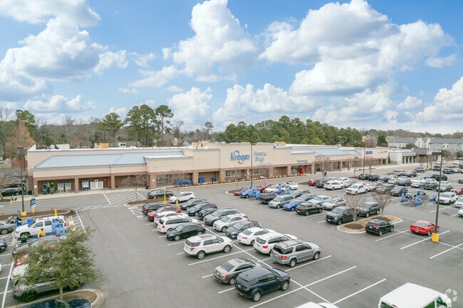
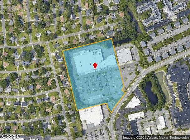
1800 Republic Rd
2407-69-1178
Kroger Plaza Shopping Ctr Hilltop
Regionalshoppingcenterormallwithanchorstore
PARCEL 1 KROGER PLAZA SHOPPING CTR HILLTOP PAR 1A 7.412 ACS
X
Virginia Beach
5155310107G
Virginia
2024
7.41 AC
2025
Hilltop/Great Neck
044807
Hampton Roads
65,687 SF
Virginia Beach-Chesapeake-Norfolk, VA-NC
DEMOGRAPHICS near 1800 Republic Rd
1 Mile
3 Mile
5 Mile
2024 Total Population
14,546
65,044
144,236
2029 Population
14,445
65,091
143,865
Pop Growth 2024-2029
(0.69%)
+ 0.07%
(0.26%)
Average Age
38
41
40
2024 Total Households
6,521
28,990
59,788
HH Growth 2024-2029
(0.84%)
+ 0.10%
(0.20%)
Median Household Inc
$66,634
$77,155
$81,418
Avg Household Size
2.20
2.20
2.30
2024 Avg HH Vehicles
2.00
2.00
2.00
Median Home Value
$306,204
$429,349
$386,340
Median Year Built
1979
1980
1979
Nearby Places
Map Layers
Map Styles
 Street
 Aerial
- Restaurants
- Banks
- Shops
- Fitness
- Groceries
PUBLIC TRANSPORTATION
AIRPORT
Norfolk International
DRIVE
WALK
Distance
Norfolk International
25 min
15.2 mi
Freight Ports
Virginia Port Authority - Portsmouth
DRIVE
WALK
Distance
Virginia Port Authority - Portsmouth
32 min
20.2 mi
SALE & LEASE HISTORY
LISTING DATE
SALE/LEASE

Nov 04, 2025
For Sale
Feb 14, 2022
For Lease
Nearby Properties
Address
Land Use
TOTAL SIZE
Lot Size
Zoning
Address
Land Use
TOTAL SIZE
Lot Size
Zoning
1,991 SF
201.95 AC
I2
Address
Land Use
TOTAL SIZE
Lot Size
Zoning
515,125 SF
24.35 AC
OR
Address
Land Use
TOTAL SIZE
Lot Size
Zoning
567,701 SF
28.93 AC
O2
Address
Land Use
TOTAL SIZE
Lot Size
Zoning
250,902 SF
21.66 AC
OR
Address
Land Use
TOTAL SIZE
Lot Size
Zoning
1 SF
25.89 AC
A18
Address
Land Use
TOTAL SIZE
Lot Size
Zoning
517,415 SF
OR
Address
Land Use
TOTAL SIZE
Lot Size
Zoning
1 SF
26.72 AC
A18
Address
Land Use
TOTAL SIZE
Lot Size
Zoning
1 SF
30.13 AC
A18
Address
Land Use
TOTAL SIZE
Lot Size
Zoning
265,955 SF
0.41 AC
Address
Land Use
TOTAL SIZE
Lot Size
Zoning
496,824 SF
2.26 AC
OR
Address
Land Use
TOTAL SIZE
Lot Size
Zoning
795,994 SF
52.17 AC
I1
Address
Land Use
TOTAL SIZE
Lot Size
Zoning
4 SF
23.34 AC
A36
Address
Land Use
TOTAL SIZE
Lot Size
Zoning
1 SF
9.78 AC
A24
Address
Land Use
TOTAL SIZE
Lot Size
Zoning
336,000 SF
10.99 AC
R5S
Address
Land Use
TOTAL SIZE
Lot Size
Zoning
13.17 AC
A36
Address
Land Use
TOTAL SIZE
Lot Size
Zoning
220,000 SF
44 SF
OR
Address
Land Use
TOTAL SIZE
Lot Size
Zoning
145,785 SF
1.05 AC
OR
Address
Land Use
TOTAL SIZE
Lot Size
Zoning
1 SF
0.02 AC
A18
Address
Land Use
TOTAL SIZE
Lot Size
Zoning
143,049 SF
0.69 AC
OR
Address
Land Use
TOTAL SIZE
Lot Size
Zoning
3.40 AC
OR
Address
Land Use
TOTAL SIZE
Lot Size
Zoning
1 SF
0.01 AC
A18
Address
Land Use
TOTAL SIZE
Lot Size
Zoning
499,120 SF
138.57 AC
R25
Address
Land Use
TOTAL SIZE
Lot Size
Zoning
199,051 SF
18.43 AC
B2
Address
Land Use
TOTAL SIZE
Lot Size
Zoning
269,180 SF
30.63 AC
R15
Address
Land Use
TOTAL SIZE
Lot Size
Zoning
4 SF
6.23 AC
A36
Address
Land Use
TOTAL SIZE
Lot Size
Zoning
13 SF
44 SF
OR
Address
Land Use
TOTAL SIZE
Lot Size
Zoning
1 SF
12.27 AC
A36
Address
Land Use
TOTAL SIZE
Lot Size
Zoning
1 SF
0.01 AC
A18
Address
Land Use
TOTAL SIZE
Lot Size
Zoning
133,169 SF
21.51 AC
R10
Address
Land Use
TOTAL SIZE
Lot Size
Zoning
12 SF
5.25 AC
OR
The World's #1 Commercial Real Estate Marketplace
Connect with us
© 2026 CoStar Group
The information above has been obtained from sources believed reliable. While we do not doubt its accuracy we have not verified it and make no guarantee, warranty or representation about it. It is your responsibility to independently confirm its accuracy and completeness. Any projections, opinions, assumptions, or estimates used are for example only and do not represent the current or future performance of the property. The value of this transaction to you depends on tax and other factors which should be evaluated by your tax, financial, and legal advisors. You and your advisors should conduct a careful, independent investigation of the property to determine to your satisfaction the suitability of the property for your needs.