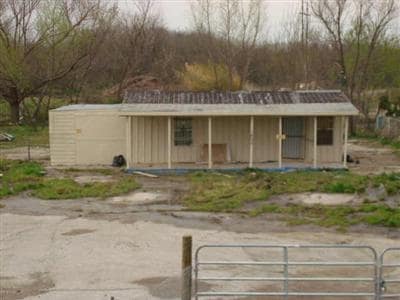
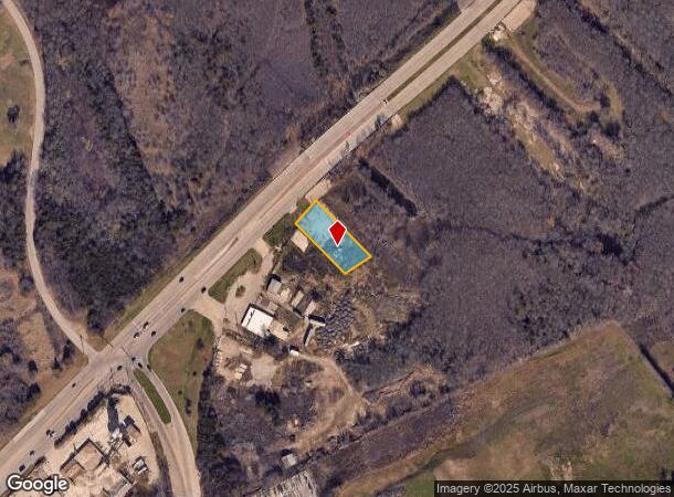
Property Record
1800 S Belt Line Rd, Mesquite, TX 75181
NEARBY LISTINGS FOR SALE OR LEASE
Property Detail
1800 S Belt Line Rd
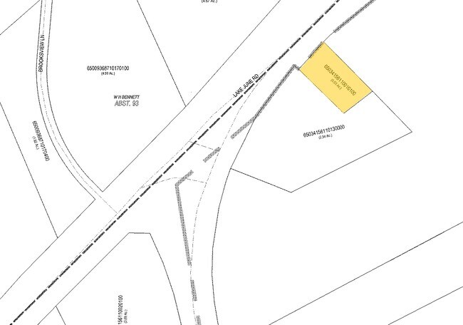
65034156110010100
Alexander Chumley
Commercialacreage
ALEXANDER CHUMLEY ABST 341 PG 561 TR 1.1 ACS 0.505 INT202400202247 DD09262024 CO-DC 0341561100101 3CM03415611
AE
Dallas
48257C0150E
Texas
2024
0.51 AC
2025
Mesquite
017314
Dallas/Ft Worth
480 SF
Dallas-Fort Worth-Arlington, TX
DEMOGRAPHICS near 1800 S Belt Line Rd
1 Mile
3 Mile
5 Mile
2024 Total Population
9,790
100,452
232,351
2029 Population
9,606
99,473
229,748
Pop Growth 2024-2029
(1.88%)
(0.97%)
(1.12%)
Average Age
36
35
34
2024 Total Households
3,189
30,219
69,495
HH Growth 2024-2029
(2.26%)
(1.25%)
(1.44%)
Median Household Inc
$68,801
$57,949
$56,280
Avg Household Size
3.00
3.20
3.20
2024 Avg HH Vehicles
2.00
2.00
2.00
Median Home Value
$197,700
$183,739
$180,776
Median Year Built
1986
1983
1983
Nearby Places
Map Layers
Map Styles
 Street
 Aerial
- Restaurants
- Banks
- Shops
- Fitness
- Groceries
PUBLIC TRANSPORTATION
AIRPORT
Dallas Love Field
DRIVE
WALK
Distance
Dallas Love Field
32 min
20.0 mi
Dallas-Fort Worth International
DRIVE
WALK
Distance
Dallas-Fort Worth International
46 min
39.0 mi
Freight Ports
Port of Shreveport
DRIVE
WALK
Distance
Port of Shreveport
201 min
186.0 mi
Nearby Properties
Address
Land Use
TOTAL SIZE
Lot Size
Zoning
Address
Land Use
TOTAL SIZE
Lot Size
Zoning
263,360 SF
42.98 AC
Z237
Address
Land Use
TOTAL SIZE
Lot Size
Zoning
441,799 SF
64.72 AC
Z05
Address
Land Use
TOTAL SIZE
Lot Size
Zoning
199,246 SF
15.32 AC
Z250
Address
Land Use
TOTAL SIZE
Lot Size
Zoning
194,385 SF
44.63 AC
Z396
Address
Land Use
TOTAL SIZE
Lot Size
Zoning
144,858 SF
9.69 AC
Z206
Address
Land Use
TOTAL SIZE
Lot Size
Zoning
200,000 SF
8.11 AC
Address
Land Use
TOTAL SIZE
Lot Size
Zoning
255,008 SF
30.39 AC
Z250
Address
Land Use
TOTAL SIZE
Lot Size
Zoning
290,916 SF
8.24 AC
Address
Land Use
TOTAL SIZE
Lot Size
Zoning
193,000 SF
34.42 AC
Z05
Address
Land Use
TOTAL SIZE
Lot Size
Zoning
1,229,138 SF
115.08 AC
Z117
Address
Land Use
TOTAL SIZE
Lot Size
Zoning
214,853 SF
6.60 AC
Z372
Address
Land Use
TOTAL SIZE
Lot Size
Zoning
407,195 SF
31.32 AC
Z109
Address
Land Use
TOTAL SIZE
Lot Size
Zoning
320,390 SF
21.50 AC
Z267
Address
Land Use
TOTAL SIZE
Lot Size
Zoning
395,065 SF
24.18 AC
Z206
Address
Land Use
TOTAL SIZE
Lot Size
Zoning
364,000 SF
40.25 AC
Z236
Address
Land Use
TOTAL SIZE
Lot Size
Zoning
298,150 SF
20.01 AC
Z14
Address
Land Use
TOTAL SIZE
Lot Size
Zoning
241,512 SF
12.61 AC
Address
Land Use
TOTAL SIZE
Lot Size
Zoning
80,461 SF
6.48 AC
Z372
Address
Land Use
TOTAL SIZE
Lot Size
Zoning
107,376 SF
38.55 AC
Z372
Address
Land Use
TOTAL SIZE
Lot Size
Zoning
267,011 SF
11.11 AC
Z250
Address
Land Use
TOTAL SIZE
Lot Size
Zoning
174,200 SF
1 AC
Z372
Address
Land Use
TOTAL SIZE
Lot Size
Zoning
110,668 SF
8.05 AC
Z372
Address
Land Use
TOTAL SIZE
Lot Size
Zoning
56,325 SF
3.84 AC
Z28
Address
Land Use
TOTAL SIZE
Lot Size
Zoning
86,875 SF
6.57 AC
Z376
Address
Land Use
TOTAL SIZE
Lot Size
Zoning
64,404 SF
19.79 AC
Z250
Address
Land Use
TOTAL SIZE
Lot Size
Zoning
238,728 SF
12.31 AC
Z184
Address
Land Use
TOTAL SIZE
Lot Size
Zoning
234,459 SF
9.71 AC
Z138
Address
Land Use
TOTAL SIZE
Lot Size
Zoning
91,871 SF
8.44 AC
Z05
Address
Land Use
TOTAL SIZE
Lot Size
Zoning
190,150 SF
13.39 AC
Z236
Address
Land Use
TOTAL SIZE
Lot Size
Zoning
64,100 SF
37.09 AC
Z396
The World's #1 Commercial Real Estate Marketplace
Connect with us
© 2025 CoStar Group
The information above has been obtained from sources believed reliable. While we do not doubt its accuracy we have not verified it and make no guarantee, warranty or representation about it. It is your responsibility to independently confirm its accuracy and completeness. Any projections, opinions, assumptions, or estimates used are for example only and do not represent the current or future performance of the property. The value of this transaction to you depends on tax and other factors which should be evaluated by your tax, financial, and legal advisors. You and your advisors should conduct a careful, independent investigation of the property to determine to your satisfaction the suitability of the property for your needs.