Property Record
1800 S Mcdonald St, Mckinney, TX 75069
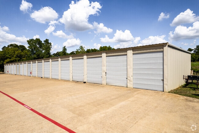

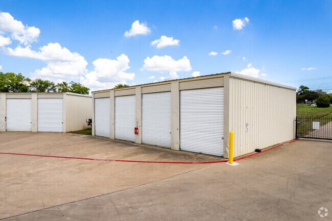
Property Detail
1800 S Mcdonald St
R-4252-00A-0030-1
TELLUS ADDITION, BLK A, LOT 3
Commercialnec
COLLIN
MH
Texas
AE The base floodplain where base flood elevations are provided. AE Zones are now used on new format FIRMs instead of A1-A30 Zones.
3
2025
3.14 AC
2025
McKinney
030903
Dallas/Ft Worth
46,895 SF
Dallas-Fort Worth-Arlington, TX
NEARBY LISTINGS FOR SALE OR LEASE
DEMOGRAPHICS near 1800 S Mcdonald St
1 mile
3 mile
5 mile
2025 Total Population
7,843
63,250
180,893
2030 Population
8,918
72,149
207,301
Pop Growth 2025-2030
+ 13.71%
+ 14.07%
+ 14.60%
Average Age
37
39
39
2025 Total Households
3,143
24,050
64,048
HH Growth 2025-2030
+ 13.87%
+ 14.31%
+ 14.79%
Median Household Inc
$64,291
$89,311
$112,968
Avg Household Size
2.40
2.50
2.80
2025 Avg HH Vehicles
2.00
2.00
2.00
Median Home Value
$346,305
$485,862
$497,623
Median Year Built
1997
1999
2005
Nearby Places
Map Layers
Map Styles
 Street
 Aerial
Layers
 Traffic
 Biking
Places
Listings with unknown addresses are not visible on the map
- Restaurants
- Banks
- Shops
- Fitness
- Groceries
PUBLIC TRANSPORTATION
AIRPORT
Dallas Love Field
Drive
Walk
Distance
Dallas Love Field
41 min
32.5 mi
Freight Ports
Port of Shreveport
Drive
Walk
Distance
Port of Shreveport
237 min
218.7 mi
Nearby Properties
Address
Land Use
TOTAL SIZE
Lot Size
Zoning
Address
Land Use
TOTAL SIZE
Lot Size
Zoning
638,539 SF
42.76 AC
Address
Land Use
TOTAL SIZE
Lot Size
Zoning
475,847 SF
16.34 AC
RG-18
Address
Land Use
TOTAL SIZE
Lot Size
Zoning
291,577 SF
69.24 AC
APTTOWNH
Address
Land Use
TOTAL SIZE
Lot Size
Zoning
260,340 SF
18.64 AC
RG-18
Address
Land Use
TOTAL SIZE
Lot Size
Zoning
879,029 SF
50.26 AC
ML
Address
Land Use
TOTAL SIZE
Lot Size
Zoning
349,991 SF
13.53 AC
MF-M
Address
Land Use
TOTAL SIZE
Lot Size
Zoning
727,459 SF
48.83 AC
Address
Land Use
TOTAL SIZE
Lot Size
Zoning
725,223 SF
46.60 AC
Address
Land Use
TOTAL SIZE
Lot Size
Zoning
356,096 SF
19.50 AC
MF-M
Address
Land Use
TOTAL SIZE
Lot Size
Zoning
337,121 SF
9.39 AC
Address
Land Use
TOTAL SIZE
Lot Size
Zoning
321,982 SF
22.83 AC
SFR
Address
Land Use
TOTAL SIZE
Lot Size
Zoning
272,853 SF
17.32 AC
PD/ML
Address
Land Use
TOTAL SIZE
Lot Size
Zoning
1,708,448 SF
85.24 AC
Address
Land Use
TOTAL SIZE
Lot Size
Zoning
281,420 SF
9.43 AC
PD/ML
Address
Land Use
TOTAL SIZE
Lot Size
Zoning
196,145 SF
18.05 AC
Address
Land Use
TOTAL SIZE
Lot Size
Zoning
201,484 SF
48.39 AC
PD/ML
Address
Land Use
TOTAL SIZE
Lot Size
Zoning
244,257 SF
8.01 AC
AG
Address
Land Use
TOTAL SIZE
Lot Size
Zoning
319,712 SF
69.85 AC
Address
Land Use
TOTAL SIZE
Lot Size
Zoning
232,400 SF
13.32 AC
RG-18
Address
Land Use
TOTAL SIZE
Lot Size
Zoning
193,037 SF
12.35 AC
MF-M
Address
Land Use
TOTAL SIZE
Lot Size
Zoning
244,074 SF
13.97 AC
Address
Land Use
TOTAL SIZE
Lot Size
Zoning
131,417 SF
12 AC
AG
Address
Land Use
TOTAL SIZE
Lot Size
Zoning
304,565 SF
19.09 AC
COMM
Address
Land Use
TOTAL SIZE
Lot Size
Zoning
174,624 SF
10.05 AC
Address
Land Use
TOTAL SIZE
Lot Size
Zoning
207,328 SF
15.10 AC
SFR
Address
Land Use
TOTAL SIZE
Lot Size
Zoning
167,735 SF
5.08 AC
PD
Address
Land Use
TOTAL SIZE
Lot Size
Zoning
211,756 SF
13.91 AC
Address
Land Use
TOTAL SIZE
Lot Size
Zoning
119,230 SF
5.44 AC
Address
Land Use
TOTAL SIZE
Lot Size
Zoning
201,899 SF
9.77 AC
MF-M
Address
Land Use
TOTAL SIZE
Lot Size
Zoning
186,291 SF
11.13 AC
The World's #1 Commercial Real Estate Marketplace
Connect with us
© 2026 CoStar Group
The information above has been obtained from sources believed reliable. While we do not doubt its accuracy we have not verified it and make no guarantee, warranty or representation about it. It is your responsibility to independently confirm its accuracy and completeness. Any projections, opinions, assumptions, or estimates used are for example only and do not represent the current or future performance of the property. The value of this transaction to you depends on tax and other factors which should be evaluated by your tax, financial, and legal advisors. You and your advisors should conduct a careful, independent investigation of the property to determine to your satisfaction the suitability of the property for your needs.